Install
Idaho weather
Cities
| City | Now | Temp | High | Low | Precip |
|---|---|---|---|---|---|
| Boise, ID | Clear | 70° | 76° | 50° | 5% |
| Meridian, ID | Forecast loading — check back in a minute. | ||||
| Nampa, ID | Clear | 63° | 73° | 44° | 6% |
| Idaho Falls, ID | Slight Chance Light Rain | 66° | 66° | 41° | 24% |
| Pocatello, ID | Forecast loading — check back in a minute. | ||||
| Caldwell, ID | Haze | 72° | 73° | 42° | 6% |
| Coeur d'Alene, ID | Clear | 64° | 69° | 44° | 1% |
| Twin Falls, ID | Clear | 63° | 74° | 47° | 16% |
| Lewiston, ID | Mostly Sunny | 70° | 72° | 45° | 1% |
| Lewiston Orchards, ID | Sunny | 67° | 69° | 44° | 3% |
| Post Falls, ID | Clear | 64° | 69° | 41° | 1% |
| Eagle Foothills, ID | Forecast loading — check back in a minute. | ||||
| Rexburg, ID | Sunny | 65° | 66° | 39° | 14% |
| Moscow, ID | Forecast loading — check back in a minute. | ||||
| Eagle, ID | Clear | 70° | 75° | 46° | 4% |
| Conda, ID | Mostly Sunny | 56° | 58° | 38° | 13% |
| Kuna, ID | Haze | 66° | 74° | 46° | 5% |
| Ammon, ID | Forecast loading — check back in a minute. | ||||
| Chubbuck, ID | Forecast loading — check back in a minute. | ||||
| Hayden, ID | Sunny | 56° | 68° | 41° | 1% |
| Mountain Home, ID | Clear | 64° | 78° | 50° | 4% |
| Blackfoot, ID | Slight Chance Light Rain | 67° | 67° | 39° | 19% |
| Garden City, ID | Clear | 70° | 75° | 49° | 5% |
| Jerome, ID | Forecast loading — check back in a minute. | ||||
| Burley, ID | Forecast loading — check back in a minute. | ||||
| Hailey, ID | Sunny | 63° | 64° | 40° | 16% |
| Sandpoint, ID | Forecast loading — check back in a minute. | ||||
| Star, ID | Clear | 61° | 74° | 43° | 5% |
| Rathdrum, ID | Forecast loading — check back in a minute. | ||||
| Payette, ID | Clear | 61° | 73° | 41° | 5% |
Radar
Full radar mapWeather news
More-
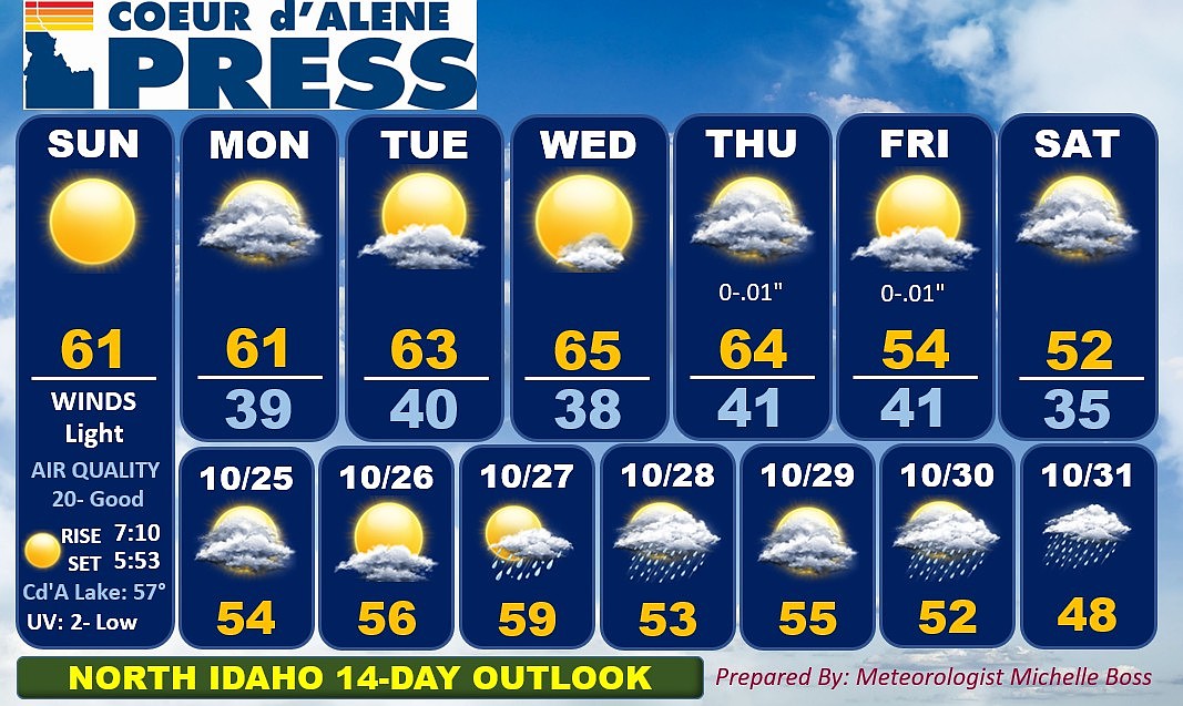 North Idaho 14-Day Weather Forecast
Coeur d'Alene Press North Idaho 14-Day Weather Forecast
-
 Sophia Cruz's Idaho News 6 Forecast - 10/16/2026
KIVI-TV Sophia Cruz's Idaho News 6 Forecast - 10/16/2026
-
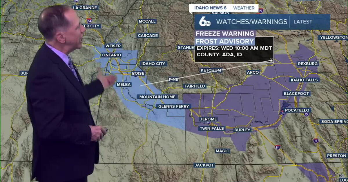 One More Frosty Morning, Then Idaho Warms Into the 70s
Wednesday morning will be the coldest part of the forecast. A Frost Advisory remains in effect for parts of the Snake River Plain, while colder air settling into the western Magic Valley will send temperatures down to…
-
 Dangerous Freeze Warnings Issued for Nevada, Idaho and Utah as Temperatures Plummet
Freeze Warnings are in effect tonight across parts of Utah, Nevada and Idaho, with lows in the mid to upper 20s on the Snake River Plain around Idaho Falls and Pocatello, and 28 in Lincoln County, Nevada. The warnings…
More places
- Middleton
- Emmett
- Rupert
- Weiser
- Preston
- Fruitland
- Shelley
- American Falls
- Buhl
- Rigby
- Lincoln
- Kimberly
- Saint Anthony
- Gooding
- Heyburn
- Fort Hall
- Grangeville
- McCall
- Orofino
- Salmon
- Soda Springs
- Wendell
- Ketchum
- Filer
- Homedale
- Bonners Ferry
- Montpelier
- Saint Maries
- Dalton Gardens
- Bellevue
- Hidden Spring
- Spirit Lake
- Parma
- Kellogg
- Iona
- Malad City
- Victor
- Aberdeen
- Priest River
- Driggs
- Wilder
- Pinehurst
- Osburn
- New Plymouth
- Shoshone
- Sun Valley
- Sugar City
- Marsing
- Moreland
- Kamiah
- Hansen
- Glenns Ferry
- Paul
- Lapwai
- Ponderay
- Ucon
- Tyhee
- Ashton
- Challis
- Plummer
- Cascade
- Arco
- Council
- Wallace
- Dubois
- Paris
- Idaho City
- Nezperce
- Fairfield
- Murphy
Forecasts, observations and alerts in the United States come from the National Weather Service (NOAA); radar from NOAA's Multi-Radar Multi-Sensor system; satellite imagery from NASA's Global Imagery Browse Services (GIBS) and NOAA's GOES satellites; the map from the U.S. Geological Survey's National Map; air quality from AirNow (EPA and its partners); hurricane information from the National Hurricane Center; climate normals and records from NOAA's Regional Climate Centers (ACIS). Forecasts outside the United States and the UV index: MET Norway (CC BY 4.0); observations outside the U.S.: airport reports via NOAA's Aviation Weather Center. Place names: GeoNames (CC BY 4.0). Data are copied on a schedule and may lag the sources; for warnings that affect your safety, follow your local National Weather Service office and emergency officials. Weather news is drawn from the 4Conservative index and reflects what the press published. Terms of use.