Install
Priceville, AL Weather
Current conditions
Observed at Decatur, Pryor Field · 27 min ago
Forecast
10-day-
Sunday
Sunny, with a high near 74.
-
Sunday Night
Mostly clear, with a low around 44.
-
Monday
Mostly sunny, with a high near 73.
National Weather Service forecast updated 2 days ago.
Hourly
Hourly forecast- Now65°
- 12 PM68°
- 1 PM71°
- 2 PM73°
- 3 PM74°
- 4 PM73°
- 5 PM70°
- 6 PM67°
- 7 PM63°
- 8 PM59°
- 9 PM55°
- 10 PM52°
- 11 PM50°
- Mon12 AM49°
- 1 AM48°
- 2 AM47°
- 3 AM46°
- 4 AM46°
- 5 AM45°
- 6 AM44°
- 7 AM45°
- 8 AM49°
- 9 AM55°
- 10 AM60°
10-day forecast
Details- TonightOct 22Clear45°
- FriOct 23Sunny47°76°
- SatOct 24Sunny45°74°
- TodayOct 25Sunny44°74°
- MonOct 26Mostly Sunny44°73°
- TueOct 27Mostly Sunny46°75°
- WedOct 28Mostly Sunny44°75°
- ThuOct 29Sunny77°
- FriOct 30Partly cloudy55°78°
- SatOct 31Rain0.34 in58°77°
Days after the National Weather Service's seven are MET Norway's outlook, a computer model with no forecaster's review.
Radar
Full mapWeather news near Priceville
More weather news-
 Alabama’s first freeze dates: When to expect cold weather in north, central and south Alabama
A few cool fall mornings are usually enough to get Alabama gardeners thinking about their tomatoes, the flowers still blooming, and the potted plants on the porch. How much longer can they stay outside? Across Alabama…
-
 Much cooler this weekend, layers highly suggested!
Temperatures for the night dropping into the upper 40s. We’ll keep the 40s around each morning, but the breeze will turn things bitter out the door this weekend. HUNTSVILLE, Ala. (WAFF) - Happy Friday! It’s much cooler…
-
 Strong fall cold front arrives today, cooler and breezy weekend ahead
WAFF HUNTSVILLE, Ala. (WAFF) - Good afternoon and happy Friday! Clouds will quickly move in for the rest of the day with early afternoon high temperatures just shy of 80 degrees. We are watching a strong fall cold front…
-
 Trudy strengthens to a hurricane as system nears Mexico’s coast with major storm expected
WAFF Trudy was located about 300 miles (480 kilometers) southwest of Acapulco, Mexico, with maximum sustained winds of 75 mph (120 kph), according to the U.S. National Hurricane Center in Miami. The hurricane was moving…
-
 Record high temperatures before a strong Friday cold front
WAFF Record high temperatures before a strong Friday cold front Alabama A&M Chief of Police Montrez Payton talks about 2026 Homecoming season updates FBI announces results of nationwide crime crackdown in Huntsville…
- 90-degree heat returns with new record highs possible across Alabama
We’re already a few weeks into fall so I’m not going to blame you for already having your pumpkins out or getting into the spooky season mindset. But here in Alabama, we always know a “faux fall” is part of the many…
-
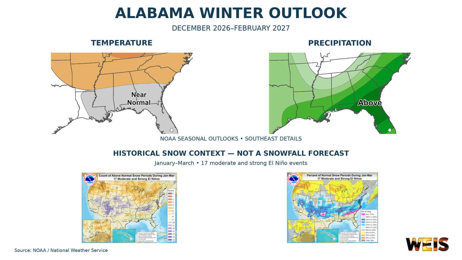 Alabama Winter Outlook Points to Wetter Conditions as El Niño Shapes the Season
CENTRE– Alabama’s winter outlook favors wetter conditions, with the strongest signal across southern Alabama and a weaker signal farther north. The outlook covers December 2026 through February 2027. NOAA released its…
- Could Alabama see perfect Thanksgiving weather? Almanac says yes
Alabama families planning to gather around the Thanksgiving table may have one less thing to worry about this year: the weather. If the Farmers' Almanac's latest forecast holds, the holiday week could bring a welcome…
-
 Alabama News Wire Forecast 10-21-2026
The Alabama News Wire
-
 First Alert Weather: Beautiful fall stretch continues: Mid-70s, sunny and dry across central Alabama
WBRC 6 News BIRMINGHAM, Ala. (WBRC) - The Next 24 Hours: We’re expecting another beautiful fall day across central Alabama, with plenty of sunshine and afternoon temperatures climbing into the mid to upper 70s. Skies…
Air quality
Air quality is satisfactory, and air pollution poses little or no risk.
Forecast
- SunModerate (51)
- MonGood (50)
Huntsville, AL reporting area · 1 hr ago. Data from AirNow (EPA and its state, local and tribal partners); preliminary and subject to change.
Sun & moon
Almanac
MonthlyHuntsville Area, records since 1907. Normals 1991–2020. Data from NOAA's Regional Climate Centers (ACIS).
Nearby
- Huntsville 36 km
- Decatur 12 km
- Madison 24 km
- Athens 32 km
- Cullman 39 km
- Hartselle 10 km
- Guntersville 58 km
- Arab 43 km
- Danville 22 km
- Meridianville 47 km
- Moores Mill 49 km
- Harvest 39 km
Forecasters' discussion
From the National Weather Service office in HUN, issued 46 min ago
Key Messages
Updated at 942 AM CDT Sun Oct 25 2026
- Afternoon RH values will drop into the 25-35% range each of the next several afternoons (mainly in southern middle Tennessee and NW Alabama), creating the need for extra caution regarding outdoor burning.
Near Term
(Rest of Today and Tonight) Issued at 942 AM CDT Sun Oct 25 2026
Another day of high pressure influence both at the surface and aloft will bring clear and calm conditions. After a night of radiational cooling, temps have climbed into the high 50s under abundant sunshine. Highs will warm to the mid 70s today for most areas with some of our terrain locations struggling to break out of the 60s.
The ridge valley split observed over the last few days will continue into the overnight hours as another high pressure induced inversion sets up. Calm winds and clear skies will support radiational cooling at the surface allowing temps to cool into the low to mid 40s. The aformentioned temperature inversion will keep temps in terrain areas a few degrees warmer closer to the mid to high 40s.
Short Term
(Monday through Wednesday) Issued at 942 AM CDT Sun Oct 25 2026
Through the short term, ridging aloft will build over the TN Valley, peaking on Tuesday. As such, temps will warm from the mid 70s on Monday to the high 70s on Tuesday. Boundary layer mixing and local inversions will continue to support ridge/valley splits in NE AL with temperature differences around 5 degrees through the early work week.
By Tuesday night a dampening mid level low will be surging NE through the Great Lakes area. This will bring some weak short waves through the area supporting an increase in cloud cover. We will be too far removed from the parent low for any increase in precip chances, yet the additional cloud cover will dissuade temps from continuing to climb, limiting highs to the mid 70s on Wednesday.
Long Term
(Tuesday night through Saturday) Issued at 1010 PM CDT Sat Oct 24 2026
The ridge will temporaily flatten on Wednesday as a dry front ripples across the Mid South/Ohio Valley, bringing some cloud cover to the area. However, given the very limited moisture, no precipitation is forecast and some limited heating will still push highs into the 70s. No air mass modification will occur behind the front (save for a reinforcing shot of drier air). In fact, a gradual warming trend will take place late next week as an upper ridge axis centered over the northern Gulf amplifies northward into the Tennessee Valley and winds veer to the SE/SSE. Highs will climb into the upper 70s on Thursday and the lower 80s in most locations Friday and Saturday to close out the month.
Forecasts, observations and alerts in the United States come from the National Weather Service (NOAA); radar from NOAA's Multi-Radar Multi-Sensor system; satellite imagery from NASA's Global Imagery Browse Services (GIBS) and NOAA's GOES satellites; the map from the U.S. Geological Survey's National Map; air quality from AirNow (EPA and its partners); hurricane information from the National Hurricane Center; climate normals and records from NOAA's Regional Climate Centers (ACIS). Forecasts outside the United States and the UV index: MET Norway (CC BY 4.0); observations outside the U.S.: airport reports via NOAA's Aviation Weather Center. Place names: GeoNames (CC BY 4.0). Data are copied on a schedule and may lag the sources; for warnings that affect your safety, follow your local National Weather Service office and emergency officials. Weather news is drawn from the 4Conservative index and reflects what the press published. Terms of use. How to use Weather