Install
Reno, NV 89599 Weather
Current conditions
Observed at EW6216 RENO · 31 min ago
Forecast
10-day-
Today
A chance of showers and thunderstorms between 2pm and 5pm, then showers and thunderstorms. Mostly cloudy, with a high near 66. Southeast wind 5 to 10 mph. Chance of precipitation is 100%. New rainfall amounts between a quarter and half of an inch possible.
-
Tonight
Showers and thunderstorms. Mostly cloudy, with a low around 43. West wind 0 to 5 mph. Chance of precipitation is 100%. New rainfall amounts between a quarter and half of an inch possible.
-
Thursday
Rain showers likely. Mostly cloudy, with a high near 58. West wind 0 to 5 mph. Chance of precipitation is 60%.
National Weather Service forecast updated 4 hrs ago.
Hourly
Hourly forecast- Now64°39%
- 4 PM65°39%
- 5 PM63°97%
- 6 PM62°97%
- 7 PM60°97%
- 8 PM57°57%
- 9 PM56°57%
- 10 PM54°57%
- 11 PM53°48%
- Thu12 AM51°48%
- 1 AM49°48%
- 2 AM48°47%
- 3 AM47°47%
- 4 AM45°47%
- 5 AM45°36%
- 6 AM44°36%
- 7 AM43°36%
- 8 AM44°51%
- 9 AM48°51%
- 10 AM50°51%
- 11 AM53°61%
- 12 PM55°61%
- 1 PM56°61%
- 2 PM57°64%
Daily forecast
Details- TodayOct 21Mostly Cloudy then Chance Showers And Thunderstorms97%43°66°
- ThuOct 22Rain Showers Likely77%39°58°
- FriOct 23Sunny11%29°58°
- SatOct 24Sunny33°62°
- SunOct 25Sunny35°66°
- MonOct 26Sunny34°65°
- TueOct 27Sunny34°63°
- WedOct 28Sunny36°57°
- ThuOct 29Sunny36°60°
Days after the National Weather Service's seven are MET Norway's outlook, a computer model with no forecaster's review.
Radar
Full mapWeather news near Reno
More weather news-
 Wednesday Web Weather
KOLO | 8 News Now RENO, Nev. (KOLO) - An area of low pressure will track into the region through Friday. Valley rain and High Sierra snow are likely at times, with snow levels mainly above 7,500′. A few thunderstorms…
-
 Tracking rain and snow chances
| Videos | 2news.com KTVN There is a slight storm chance on Tuesday, with a much better chance for valley rain and mountain snow on Wednesday and Thursday. Churchill County Search and Rescue say three stranded children…
-
 Gusty, sunny Monday in store for Reno, Lake Tahoe
KRXI2 Typical fall weather seems to be finally making its way into northern Nevada this week! But on Monday, we're sticking in the 70s, with a high of 75 degrees in Reno and sunny conditions We'll be on fire weather…
-
 Tuesday Web Weather
KOLO | 8 News Now RENO, Nev. (KOLO) - An area of low pressure will drop down the coast on Tuesday and then track into the region Wednesday through Friday. Valley rain and High Sierra snow are likely at times, with snow…
-
 More sunshine, dry conditions to wrap up your weekend in Reno
KRXI2 It's been warm and dry all weekend here in northern Nevada, and those beautiful conditions will stick around for your Sunday Reno's forecasted high comes in at 78 degrees, a little warmer than it typically is this…
-
 Storms on the way next week, warm weekend temperatures
KOLO | 8 News Now RENO, Nev. (KOLO) - Warm weather is sticking around for the rest of this weekend. Starting on Monday temperatures will cool down, and wind will increase as a storm moves our way. This will increase…
-
 Sunshine, warmer temperatures continue across northern Nevada Saturday
A beautiful Friday evening from News4/FOX11's Porsche Reno SkyCam Saturday is shaping up to be a beautiful day across the Truckee Meadows, with plenty of sunshine and temperatures climbing into the upper 70s in Reno…
-
 Sunny and warm for the weekend… cooler weather next week.
| Storm Watch Weather | 2news.com KTVN Sunny and warm for the weekend⦠cooler weather next week. Banana Ball to return to Reno Nobody hurt in crash Ronald McDonald House ribbon cutting
-
 Evening weather forecast for October 16
| Videos | 2news.com KTVN Warm and dry weather prevails through the weekend with east to southeast breezes this afternoon. Increasing south to southwest winds by Monday afternoon as a storm approaches the west coast…
-
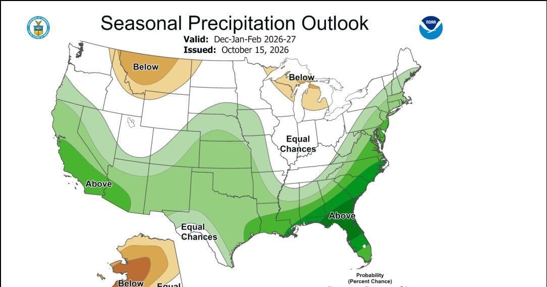 Winter forecast myths
According to the Climate Prediction Center the winter forecast including the months of December, January, and February, is leaning wetter and warmer than average in the Truckee Meadows and around Lake Tahoe. There is a…
Air quality
Air quality is satisfactory, and air pollution poses little or no risk.
Forecast
- WedGood
- ThuGood
- FriGood
Reno-Sparks, NV reporting area · 1 hr ago. Data from AirNow (EPA and its state, local and tribal partners); preliminary and subject to change.
Sun & moon
Almanac
MonthlyVirginia City, records since 1887. Normals 1991–2020. Data from NOAA's Regional Climate Centers (ACIS).
Nearby
- Sparks 5 km
- Carson City 41 km
- Fernley 49 km
- Sun Valley 8 km
- Truckee 39 km
- Spanish Springs 16 km
- Dayton 38 km
- Incline Village 34 km
- Cold Springs 22 km
- Johnson Lane 54 km
- Indian Hills 49 km
- Silver Springs 52 km
Forecasters' discussion
From the National Weather Service office in REV, issued 3 hrs ago
Key Messages
* A slow moving storm will bring widespread wetting rain with thunderstorms and high elevation snow to the region through Thursday evening.
* Cool, but mainly dry, Friday into early next week. A more active storm pattern may return by the end of October.
Discussion
Showers are beginning to fill the radar returns to our west and southeast and will begin to fill the skies over the Sierra today. By this afternoon, many across western Nevada and the Sierra will be seeing raindrops.
TODAY->THURSDAY: STORMY DAYS
* RAIN & THUNDERSTORMS: An ample moisture plume is arriving today, which is why WPC has a 5% risk of heavy rainfall capable of producing flooding from around Reno/Fallon to the south. Widespread rainfall will begin to arrive this afternoon, with a 50-80% chance of up to 0.25" of precipitation. Bands of showers will arrive to the Sierra, then the Tahoe Basin, working over the mountains into western Nevada, then eventually spilling northward to the north of I-80. Localized heavy rain of up to 1" is possible, which may trigger flooding in poor drainage areas and over burn scars. Through this evening, a range of 0.50-1.25" of precipitation is possible, with the highest amounts along the Sierra and leeside Sierra Foothills. The lower end of the range will be found across Reno/Fernley/Carson City/Smith Valley, while even lower amounts of 0.25-0.50" will fall over Fallon/Yerington/Hawthorne. Additional rounds of precipitation are expected to continue overnight into Thursday. Additional precipitation amounts for Thursday over the Sierra will range 0.5-1.25" with the higher amounts found over the northern Sierra and north to the Oregon border, along the Sierra Crest (excluding the Tahoe Basin), over to the east to Churchill County and then to the south over southern Mineral County and to the White Mountains of Mono County. Thunderstorm chances peak at 25-30% this afternoon, decreasing to 15-20% for Thursday.
* HIGH ELEVATION SNOW: Snow levels for today will remain above 8500 feet until nightfall, when they will begin to descend. By Thursday morning, snow levels will have fallen to around 8000 feet, bringing snow to the highest mountain passes. Snow levels will fall by Thursday morning to around 7500 feet, then further fall below 7000 feet for southern Mono County as the moisture lifts to the north. For the entire storm system, a 70% chance for 2" of snow, and a 25% chance for 4" of snow exists for locations above 8000 ft. There may be totals as high as 10", but those totals will only be found on the highest peaks. Any road accumulations will largely be found on the higher passes (Ebbetts, Tioga, Sonora). US-395 may see some snow flying through the air, but accumulations will be limited to the most elevated stretches and totals will remain below 1" of snow.
* TEMPERATURES AND WINDS: This system is bringing with it some cooler air that will bring our high temperatures down to the 50s and low-60s for lower elevations and mid-40s to low-50s for the Sierra. Brisk W-NW winds will reinforce the cooler air, with gusts 25-35+ mph along and north of US-50 by Thursday night.
* PREPARE, STAY AWARE AHEAD OF TRAVEL: Prepare your home by checking the gutters and drains and clearing them if you have not already done so. Make plans to leave early Thursday morning, since the roads will be wet in many areas, which may lead to slower commute times.
Aviation
* Widespread rain and embedded thunderstorms bring periods of MVFR/IFR conditions and mountain obscurations starting around 21/22z today and lasting through much of Thursday. Thunderstorm chances peak at 25-30% this afternoon, decreasing to 15-20% for Thursday.
* Winds will be light overall through Thursday afternoon, though heavier thundershowers may trigger brief gusts to 30+ kts. A cold frontal passage will bring W-NW gusts of 20-25 kts. Thursday night for KRNO/KTRK. HRICH
Forecasts, observations and alerts in the United States come from the National Weather Service (NOAA); radar from NOAA's Multi-Radar Multi-Sensor system; satellite imagery from NASA's Global Imagery Browse Services (GIBS) and NOAA's GOES satellites; the map from the U.S. Geological Survey's National Map; air quality from AirNow (EPA and its partners); hurricane information from the National Hurricane Center; climate normals and records from NOAA's Regional Climate Centers (ACIS). Forecasts outside the United States and the UV index: MET Norway (CC BY 4.0); observations outside the U.S.: airport reports via NOAA's Aviation Weather Center. Place names: GeoNames (CC BY 4.0). Data are copied on a schedule and may lag the sources; for warnings that affect your safety, follow your local National Weather Service office and emergency officials. Weather news is drawn from the 4Conservative index and reflects what the press published. Terms of use.