Install
Spanish Springs, NV Weather
Current conditions
Forecast for this hour (no station report in the last two hours)
Forecast
10-day-
Today
Mostly sunny, with a high near 65. West wind around 0 mph.
-
Tonight
Partly cloudy, with a low around 33. Southwest wind 0 to 5 mph.
-
Monday
Sunny, with a high near 63. Southwest wind 5 to 25 mph, with gusts as high as 40 mph.
National Weather Service forecast updated 13 hrs ago.
Hourly
Hourly forecast- Now65°
- 6 PM62°
- 7 PM59°
- 8 PM56°
- 9 PM50°
- 10 PM48°
- 11 PM46°
- Mon12 AM43°
- 1 AM41°
- 2 AM40°
- 3 AM38°
- 4 AM35°
- 5 AM35°
- 6 AM33°
- 7 AM33°
- 8 AM35°
- 9 AM42°
- 10 AM49°
- 11 AM53°
- 12 PM56°
- 1 PM58°
- 2 PM60°
- 3 PM61°
- 4 PM60°
Daily forecast
Details- TodayOct 25Mostly Sunny33°65°
- MonOct 26Sunny28°63°
- TueOct 27Sunny31°62°
- WedOct 28Mostly Sunny33°63°
- ThuOct 29Partly Sunny16%30°61°
- FriOct 30Slight Chance Light Rain33%27°55°
- SatOct 31Chance Light Snow then Chance Light Rain33%25°50°
- SunNov 1Sunny26°47°
- MonNov 2Cloudy25°49°
Days after the National Weather Service's seven are MET Norway's outlook, a computer model with no forecaster's review.
Radar
Full mapWeather news near Spanish Springs
More weather news-
 Tuesday Web Weather
KOLO | 8 News Now RENO, Nev. (KOLO) - An area of low pressure will drop down the coast on Tuesday and then track into the region Wednesday through Friday. Valley rain and High Sierra snow are likely at times, with snow…
-
 More sunshine, dry conditions to wrap up your weekend in Reno
KRXI2 It's been warm and dry all weekend here in northern Nevada, and those beautiful conditions will stick around for your Sunday Reno's forecasted high comes in at 78 degrees, a little warmer than it typically is this…
-
 Storms on the way next week, warm weekend temperatures
KOLO | 8 News Now RENO, Nev. (KOLO) - Warm weather is sticking around for the rest of this weekend. Starting on Monday temperatures will cool down, and wind will increase as a storm moves our way. This will increase…
-
 Sunshine, warmer temperatures continue across northern Nevada Saturday
A beautiful Friday evening from News4/FOX11's Porsche Reno SkyCam Saturday is shaping up to be a beautiful day across the Truckee Meadows, with plenty of sunshine and temperatures climbing into the upper 70s in Reno…
-
 Evening weather forecast for October 16
| Videos | 2news.com KTVN Warm and dry weather prevails through the weekend with east to southeast breezes this afternoon. Increasing south to southwest winds by Monday afternoon as a storm approaches the west coast…
-
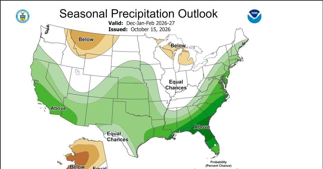 Winter forecast myths
According to the Climate Prediction Center the winter forecast including the months of December, January, and February, is leaning wetter and warmer than average in the Truckee Meadows and around Lake Tahoe. There is a…
-
 Sunny and warm for the weekend… cooler weather next week.
| Storm Watch Weather | 2news.com KTVN Sunny and warm for the weekend⦠cooler weather next week. Banana Ball to return to Reno Nobody hurt in crash Ronald McDonald House ribbon cutting
-
 Saturday Web Weather
KOLO | 8 News Now RENO, Nev. (KOLO) - Expect clear, chilly nights, with warm days in the forecast through Sunday. A system will bring more wind, showers, and cooler weather by the middle of next week. Wednesday and…
-
 Occasional periods of fire weather ahead of warm weekend
| Storm Watch Weather | 2news.com KTVN Highs well above average Saturday and Sunday. Banana Ball to return to Reno Under the Arch Madness event Nobody hurt in crash
-
 Evening weather forecast for October 15
| Videos | 2news.com KTVN Warmer conditions prevail through this weekend. Increased east to southeast breezes through Friday with stronger ridge top winds peaking tonight. Cooler temperatures return next week with…
Air quality
Air quality is satisfactory, and air pollution poses little or no risk.
Forecast
- SunGood
- MonGood
- TueGood
Reno-Sparks, NV reporting area · 1 hr ago. Data from AirNow (EPA and its state, local and tribal partners); preliminary and subject to change.
Sun & moon
Almanac
MonthlyReno Area, records since 1893. Normals 1991–2020. Data from NOAA's Regional Climate Centers (ACIS).
Nearby
- Reno 16 km
- Sparks 13 km
- Carson City 54 km
- Fernley 39 km
- Sun Valley 8 km
- Truckee 54 km
- Dayton 47 km
- Incline Village 50 km
- Cold Springs 23 km
- Silver Springs 49 km
- Lemmon Valley 12 km
- Kings Beach 53 km
Forecasters' discussion
From the National Weather Service office in REV, issued 5 hrs ago
Key Messages
* Gusty southwest winds are expected Monday with gusts of around 30-40 mph for most areas. Light rain and mountain snow chances for northeast California.
* Mostly dry and cool conditions will prevail through Wednesday, with temperatures near to just below season averages.
* Increasing chances for unsettled weather and cooler temperatures to return late week into the first week of November.
Discussion
Sunny skies and near average temperatures will give way to increasing clouds and gusty Sierra ridgetop winds late this afternoon and evening as a low pressure system approaches.
Ridgetop gusts will increase to 50-60 mph this evening, then near 80 mph by early Monday morning. Surface gusts will generally reach 30-40 mph for the valleys by Monday afternoon. These winds may create hazardous boating conditions and impact outdoor recreation and travel, with aviation turbulence, wind shear, and crosswinds for high profile vehicles. Lake Wind Advisories have been issued Monday for area lakes across western Nevada and the eastern Sierra.
Mondays system will also bring a 25-35% chance for light showers, mainly across eastern Modoc and far N.Washoe counties near the Oregon border. Otherwise, dry conditions and slightly below average temperatures will persist through Thursday. 10-20% chance of showers are expected along the Sierra crest in Mono County by Thursday evening.
Another upper-level trough is expected to develop along the West Coast next weekend. Chances for light rain and mountain snow showers will increase from 15-30% Friday to 20-40% by Sunday. Cool weather persists, with highs in the 40s to low 50s across the Sierra and western Nevada and lows in the 20s and 30s. Extended outlooks favor wetter and cooler than average conditions into the first week of November as a series of low pressure systems moves through the region. Fuentes
Aviation
VFR conditions, light winds, and seasonable temperatures continue though Sunday. Then, an incoming low pressure system will likely bring mountain wave turbulence and LLWS Sunday night into Monday with terminal gusts of 25-35 kt Monday afternoon.
Forecasts, observations and alerts in the United States come from the National Weather Service (NOAA); radar from NOAA's Multi-Radar Multi-Sensor system; satellite imagery from NASA's Global Imagery Browse Services (GIBS) and NOAA's GOES satellites; the map from the U.S. Geological Survey's National Map; air quality from AirNow (EPA and its partners); hurricane information from the National Hurricane Center; climate normals and records from NOAA's Regional Climate Centers (ACIS). Forecasts outside the United States and the UV index: MET Norway (CC BY 4.0); observations outside the U.S.: airport reports via NOAA's Aviation Weather Center. Place names: GeoNames (CC BY 4.0). Data are copied on a schedule and may lag the sources; for warnings that affect your safety, follow your local National Weather Service office and emergency officials. Weather news is drawn from the 4Conservative index and reflects what the press published. Terms of use. How to use Weather