Install
Homestead Meadows North, TX Weather
Current conditions
Observed at El Paso, El Paso International Airport · 1 hr ago
Forecast
10-day-
Sunday
A slight chance of rain showers. Mostly sunny, with a high near 74. South wind around 6 mph. Chance of precipitation is 20%.
-
Sunday Night
A slight chance of showers and thunderstorms. Partly cloudy, with a low around 56. Chance of precipitation is 20%.
-
Monday
A slight chance of rain showers. Mostly sunny, with a high near 72. Chance of precipitation is 20%.
National Weather Service forecast updated 4 days ago.
Hourly
Hourly forecast- Now73°17%
- 6 PM71°22%
- 7 PM69°22%
- 8 PM66°22%
- 9 PM64°22%
- 10 PM63°22%
- 11 PM62°22%
- Mon12 AM61°18%
- 1 AM60°18%
- 2 AM59°18%
- 3 AM58°18%
- 4 AM57°18%
- 5 AM56°18%
- 6 AM56°15%
- 7 AM57°15%
- 8 AM58°15%
- 9 AM60°15%
- 10 AM63°15%
- 11 AM66°15%
- 12 PM69°19%
- 1 PM70°19%
- 2 PM71°19%
- 3 PM72°19%
- 4 PM72°19%
10-day forecast
Details- WedOct 21Partly Sunny64°86°
- ThuOct 22Mostly Cloudy then Slight Chance Rain Showers32%63°85°
- FriOct 23Mostly Sunny then Chance Showers And Thunderstorms77%58°80°
- SatOct 24Chance Showers And Thunderstorms66%57°77°
- TodayOct 25Slight Chance Rain Showers22%56°74°
- MonOct 26Slight Chance Rain Showers19%54°72°
- TueOct 27Mostly Sunny54°70°
- WedOct 28Cloudy59°80°
- ThuOct 29Cloudy54°76°
- FriOct 30Rain0.26 in56°63°
Days after the National Weather Service's seven are MET Norway's outlook, a computer model with no forecaster's review.
Radar
Full mapWeather news near Homestead Meadows North
More weather news-
 ABC-7 StormTrack Weather: Light rain chances tonight, average temps
EL PASO, Texas (KVIA) -- Monday's forecast will lean comfortable to start however rain chances will increase into midafternoon and early evening. We woke this morning to some wet roadways and chilly temps after…
-
 ABC-7 StormTrack Weather: Cooler temperatures Sunday and Monday as rain chances return
EL PASO, Texas (KVIA) -- Temperatures tracking to remain cool Sunday and Monday, then climb back above normal starting Tuesday. The warming trend will continue even as rain chances increase in the forecast. Rain chances…
- ABC-7 StormTrack Weather: Chilly Saturday before temperatures climb into the 80s
EL PASO, Texas (KVIA) -- Grab a jacket before heading out this Saturday morning! Cool October air is keeping temperatures well below normal across the Borderland, but a big warmup is on the way. Lowland highs tracking…
-
 ABC-7 First Alert Continues: Coldest Temperatures of the Season Arrive, Strong Winds and Blowing Dust Continue
EL PASO, Texas (ABC-7) — El Paso and the Borderland are in for a significant cooldown, with the coldest temperatures of the season so far arriving tonight. Temperatures will dip into the low 40s across much of the…
-
 First Freeze of the Season Tonight in the Texas Panhandle
The first freeze of the fall season hits the Texas Panhandle and South Plains tonight, with 28 in Dalhart. Crashy the Cold Front has arrived, bringing gusty north winds and Extreme fire danger to East Texas today. Texas…
-
 ABC-7 First Alert: High winds, blowing dust, cooler temps
EL PASO, Texas (KVIA) -- We remain under an ABC-7 First alert because of strong winds and cooler temps. Expect strong winds, blowing dust, and cooler temps! The National Weather Service has issued a weather alert for…
-
 Massive cold front triggers Texas freeze watch-which counties are at risk?
A cold front is barreling toward Texas, and some counties are under a freeze watch, with temperatures expected to dip below freezing. The National Weather Service has issued a freeze watch for counties most likely to…
-
 Freeze Watch issued for parts of Texas. Are you in its path?
Flowers are covered in ice as intense cold settles into the Austin area, Jan. 25, 2026. Parts of the state are under a Freeze Watch this weekend as a cold front sweeps through Texas. A cold front is barreling toward…
-
 ABC-7 First Alert Continues: Strong Backdoor Cold Front Brings Very Strong Winds, Sharp Temperature Drop to the Borderland
A powerful cold front is moving into the Borderland tonight, bringing a dramatic shift in winds, much colder temperatures and the potential for blowing dust across parts of the region. The cold front is expected to…
-
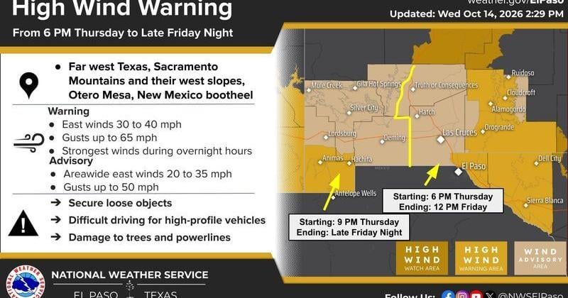 The National Weather Service in El Paso has issued a High Wind Warning and Wind Advisory for portions of far West Texas and southern New Mexico beginning Thursday evening, Oct. 15, and continuing into Friday, Oct. 16.
The Lufkin Daily News The National Weather Service in El Paso has issued a High Wind Warning and Wind Advisory for portions of far West Texas and southern New Mexico beginning Thursday evening, Oct. 15, and continuing…
Air quality
Acceptable. Unusually sensitive people should consider limiting prolonged outdoor exertion.
Forecast
- SunGood
- MonModerate
- TueModerate
El Paso, TX reporting area · 1 hr ago. Data from AirNow (EPA and its state, local and tribal partners); preliminary and subject to change.
Sun & moon
Almanac
MonthlyEl Paso Area, records since 1887. Normals 1991–2020. Data from NOAA's Regional Climate Centers (ACIS).
Nearby
- Ciudad Juárez 31 km
- El Paso 31 km
- Socorro 25 km
- Socorro Mission Number 1 Colonia 26 km
- Horizon City 18 km
- Sunland Park 39 km
- Chaparral 28 km
- Anthony 44 km
- San Elizario 31 km
- Fort Bliss 23 km
- Fabens 39 km
- Homestead Meadows South 4 km
Forecasters' discussion
From the National Weather Service office in EPZ, issued 5 hrs ago
Key Messages
Updated at 1112 AM MDT Sun Oct 25 2026
- Storm chances shift east on Sunday and Monday, limited mostly to Hudspeth and Otero Counties. A few storms will be capable of large hail, gusty winds, and excessive rainfall leading to localized flash flooding.
- A few days of drier weather is expected midweek before rain chances return Thursday into next weekend.
- Typical late-October temperatures, with lowland highs in the lower to mid 70s.
Discussion
Issued at 1112 AM MDT Sun Oct 25 2026
The weather pattern will be somewhat less active this afternoon and evening as the large low pressure system near the Four Corners Region lifts out of the area to the east. the Sub-tropical jet remains near the area and will continue to help generate isolated to scattered thunderstorm development over areas east of the Rio Grande late this afternoon and overnight. The most likely areas of storm development will be in Otero, Hudspeth, El Paso Counties and locations to the east. There will be a few isolated thunderstorms in the afternoon, but the most active period will be later in the evening after 9 pm when a short wave trough embedded in the flow pattern helps generate scattered strong thunderstorm development. The severe threat from storms will be reduced but still possible. There is a potential for excessive rainfall with flash flooding from a few storms, but should not be as widespread as previous days.
Monday should be a quieter day as the local forecast area will be west of the trough axis with a drier, more stable mass moving into the region. Short range models seem to reflect this with only a few brief isolated storms for areas east of El Paso in the evening hours. Tuesday and Wednesday will be dry for southern New Mexico and Far West Texas as a dry westerly zonal flow sets up over the region. Temperatures will be near seasonal in most areas.
We will return to a more active weather pattern Thursday and Friday as another trough sets up on the west coast and a ridge builds over the Gulf Coast. This pattern will allow moisture back into the region that will help fuel scattered showers and thunderstorms across the area both days.
The outlook for Halloween on Saturday looks dry with a short wave ridge moving over the state for a short period of quiet weather. Active weather returns to the area next Sunday as the trough on the west coast deepens and moves inland toward New Mexico.
Aviation
(18Z TAFS) Issued at 1112 AM MDT Sun Oct 25 2026
VMC prevailing at local terminals today. Isolated TS across W TX and SE NM this afternoon and evening. Storms may be too far east to directly affect KLRU. Storms may develop close to KELP to mention VCTS this evening but not confident enough to say KELP may be directly impacted. Surface winds 170-200 at 5 to 10 knots this afternoon, becoming 320-060 AOB 5 knots tonight. Skies FEW- SCT080, SCT- BKN250 today with greater cloud coverage east of KELP.
Fire Weather
Issued at 1112 AM MDT Sun Oct 25 2026
Dry conditions for Gila NF, but scattered thunderstorms are expected again across Lincoln NF this afternoon and evening. Storms will be capable of gusty winds and localized flooding. Prevailing wind out of the SSW at 5 to 10 mph, with Good vent rates today. Lighter winds Monday/Tuesday will keep vent rates Poor to Fair through most of the afternoon hours.
Moisture shifts further east early this week, leading to a brief window of dry conditions area wide. Rain chances return Thursday into next weekend, leading to another round of wetting precipitation over the forested areas. ERCs are very low at the moment, so no fire danger expected into early November.
Forecasts, observations and alerts in the United States come from the National Weather Service (NOAA); radar from NOAA's Multi-Radar Multi-Sensor system; satellite imagery from NASA's Global Imagery Browse Services (GIBS) and NOAA's GOES satellites; the map from the U.S. Geological Survey's National Map; air quality from AirNow (EPA and its partners); hurricane information from the National Hurricane Center; climate normals and records from NOAA's Regional Climate Centers (ACIS). Forecasts outside the United States and the UV index: MET Norway (CC BY 4.0); observations outside the U.S.: airport reports via NOAA's Aviation Weather Center. Place names: GeoNames (CC BY 4.0). Data are copied on a schedule and may lag the sources; for warnings that affect your safety, follow your local National Weather Service office and emergency officials. Weather news is drawn from the 4Conservative index and reflects what the press published. Terms of use. How to use Weather