Install
Santa Clara Pueblo, NM Weather
Current conditions
Forecast for this hour (no station report in the last two hours)
Forecast
10-day-
Saturday
Rain showers likely before 9am, then showers and thunderstorms likely. Cloudy, with a high near 64. Chance of precipitation is 70%.
-
Saturday Night
Showers and thunderstorms. Mostly cloudy, with a low around 43. Chance of precipitation is 80%.
-
Sunday
A chance of rain showers before noon, then a chance of showers and thunderstorms. Partly sunny, with a high near 65. Chance of precipitation is 50%.
National Weather Service forecast updated 3 days ago.
Hourly
Hourly forecast- Now63°64%
- 4 PM62°64%
- 5 PM60°64%
- 6 PM60°81%
- 7 PM58°81%
- 8 PM55°81%
- 9 PM53°81%
- 10 PM52°81%
- 11 PM50°81%
- Sun12 AM49°76%
- 1 AM47°76%
- 2 AM46°76%
- 3 AM45°76%
- 4 AM44°76%
- 5 AM43°76%
- 6 AM43°49%
- 7 AM44°49%
- 8 AM46°49%
- 9 AM49°49%
- 10 AM53°49%
- 11 AM57°49%
- 12 PM60°38%
- 1 PM63°38%
- 2 PM64°38%
10-day forecast
Details- WedOct 21Partly Sunny28%51°76°
- ThuOct 22Partly Sunny then Chance Showers And Thunderstorms57%52°73°
- FriOct 23Slight Chance Showers And Thunderstorms then Chance Showers And Thunderstorms72%47°70°
- TodayOct 24Showers And Thunderstorms Likely81%43°64°
- SunOct 25Chance Rain Showers49%36°65°
- MonOct 26Mostly Sunny36°66°
- TueOct 27Sunny36°67°
- WedOct 28Partly cloudy36°59°
- ThuOct 29Cloudy39°60°
- FriOct 30Cloudy0.02 in43°59°
Days after the National Weather Service's seven are MET Norway's outlook, a computer model with no forecaster's review.
Radar
Full mapWeather news in New Mexico
More weather news-
 Tornado watch and flood threat in western New Mexico Thursday night
ALBUQUERQUE, N.M. – A tornado watch and flood watch cover western New Mexico as strong storms threaten damaging winds, large hail, torrential rain and a possible tornado. A strong Pacific storm system moved into…
-
 Flood watches issued as Arizona storms spill into New Mexico
Storms that brought heavy rain, egg-sized hail and tornadoes to Arizona on Wednesday struck western New Mexico by the afternoon, generating flood watches set to remain in effect through Friday. Forecasters told the…
- Tracking severe weather in New Mexico
Severe weather is moving through New Mexico prompting a tornado watch for western New Mexico and a severe thunderstorm watch for Albuquerque. 5:13 pm - Evacuations have been suggested for areas along the San Juan River…
- Severe Thunderstorm Watch issued for Albuquerque and central New Mexico
CURRENT CONDITIONS | CURRENT WATCHES AND WARNINGS | LIVE RADAR | UPLOAD YOUR WEATHER PHOTOS | TURN ON WEATHER NOTIFICATIONS The National Weather Service has issued a severe thunderstorm watch for Bernalillo, Los Alamos…
- Tornado watch issued for parts of western New Mexico
A tornado watch has been issued for parts of western New Mexico through Thursday evening. The tornado watch includes San Juan, Catron, Cibola, Grant, Hidalgo and McKinley Counties. The cities of Farmington, Crownpoint…
-
 Rain slowly pushing eastward in New Mexico but still mostly in Four Corners
ALBUQUERQUE, N.M. — A big upper-level low is slowly moving inland and is still pulling a lot of moisture that will make its way to New Mexico. Most of the activity Thursday will still favor western New Mexico, say from…
-
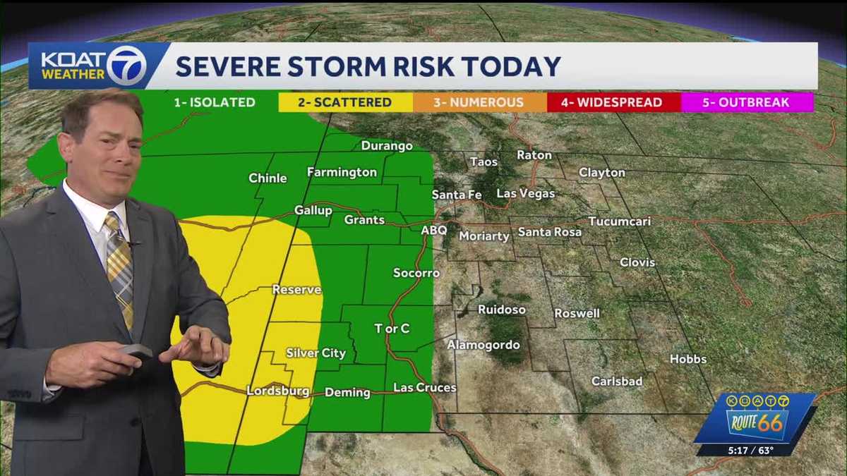 Flood Watches in effect for Western New Mexico, active Severe Thunderstorm Watch for Northeast Arizona
KOAT Flood Watches in effect for Western New Mexico, active Severe Thunderstorm Watch for Northeast Arizona Tropical moisture surge making a slow push eastward over next few days drenching the state, flood threat and…
-
 Heavy rain could bring flash flooding to New Mexico, southwest Colorado through Friday
KRQE A strong storm system will bring widespread rain to New Mexico and southwest Colorado starting Wednesday, with several inches of rain possible in some areas through Friday Heavy rainfall could lead to flash…
-
 Southwestern New Mexico residents say they spotted two tornadoes
Clouds in Deming are seen amid a tornado warning Monday evening. The National Weather Service’s El Paso office could not confirm whether a tornado touched down, meteorologist in charge Greg Lundeen said Tuesday. A…
-
 Active weather pattern in New Mexico takes a slight lull Tuesday
ALBUQUERQUE, N.M. — An active stretch of weather in New Mexico continued Tuesday morning but the afternoon and evening will see it take a slight lull. The Albuquerque metro saw some rain overnight. However, drier air is…
Air quality
Air quality is satisfactory, and air pollution poses little or no risk.
Santa Fe, NM reporting area · 1 hr ago. Data from AirNow (EPA and its state, local and tribal partners); preliminary and subject to change.
Sun & moon
Almanac
MonthlyAlcalde, records since 1953. Normals 1991–2020. Data from NOAA's Regional Climate Centers (ACIS).
Nearby
- Santa Fe 34 km
- Los Alamos 21 km
- Española 3 km
- Eldorado at Santa Fe 51 km
- White Rock 19 km
- La Cienega 45 km
- Chimayo 13 km
- Agua Fria 35 km
- Santa Teresa 57 km
- Santo Domingo Pueblo 56 km
Forecasters' discussion
From the National Weather Service office in ABQ, issued 3 hrs ago
Key Messages
Issued at 1139 AM MDT Sat Oct 24 2026
- Severe thunderstorms are forecast to return to the forecast area this afternoon and evening, when large hail and damaging winds will be the main threats, with a lower risk of isolated tornadoes.
- River flooding will continue over parts of central and northwest New Mexico today and tonight.
- Heavy rainfall will impact central and eastern parts of the forecast area today and tonight with a continued risk of flash flooding. The risk of heavy rainfall and flash flooding will persist east of the central mountain chain Sunday and Sunday night.
Short Term
(Today through Sunday night) Issued at 118 AM MDT Sat Oct 24 2026
The second upper level low pressure system in a series of two impacting the forecast area with widespread heavy rain has formed over southern CA. It will eject northeastward over the Four Corners and CO Sunday and Sunday night. This slow-moving storm system will again draw extremely rich subtropical moisture northward over the forecast area producing widespread showers and thunderstorms over central and eastern areas today and tonight with scattered to numerous activity westward to the AZ border. Sunday and Sunday night, the focus for widespread showers and thunderstorms will shift over the eastern plains with scattered to numerous cells over central areas. Models depict a line of clearing that will advance northeastward across southwest and west-central areas Saturday night, but there is less certainty about how much eastward progress the dryslot will be able to make on Sunday. GEFS ensemble PWATS are forecast to peak around 160-250 percent of normal over central, northern, and eastern areas this afternoon through tonight, with values closer to normal farther southwest. PWATs will then trend downward over central and western areas Sunday, while very high values persist across the plains. With actual PWATs around 0.80-1.15", stronger storms along and east of the central mountain chain will again be capable of producing locally heavy rainfall at rates near and over 1"/hr today and tonight, then again east of the central mountain chain Sunday and Sunday night. Additional rain amounts today through Sunday night are progged to reach around 0.50-3.0" along and east of the central mountain chain with the heaviest amounts northeast, and mostly lighter amounts elsewhere. NBM 90th Percentile QPF, which indicates what a few of the higher rainfall totals will probably end up being, reaches 4-6" on the eastern plains, and 2-3" along the central mountain chain, over north central areas, and across the northwest mountains and northwest highlands. This upper-end scenario also indicates up to 1.5" of rain will be possible in parts of the Albuquerque area with higher amounts of 2-3" in the urban corridor north of Albuquerque to Taos. With this forecast package we will continue a Flash Flood Watch today through tonight from Navajo Lake eastward and southeastward to Capulin, Conchas, Fort Sumner, Roswell, and Ruidoso; including Albuquerque and Santa Fe. Later shifts will probably extend and expand the Watch over eastern areas for Sunday and Sunday evening.
A few inches of snow are also forecast on the highest peaks of the Sangre de Cristo Mountains Saturday night through Sunday night, where 700 mb temperatures look to bottom out around +2 to +4 C. Otherwise, high temperatures across the forecast area will continue to trend cooler through the weekend, when readings should vary from a few to around 9 degrees below 30-year averages.
Long Term
(Monday through Friday) Issued at 118 AM MDT Sat Oct 24 2026
On Monday, scattered to numerous showers and thunderstorms will continue over east central and southeast areas, where moist southeast low level return flow will develop as a weak trailing disturbance crosses aloft. PWATs are forecast to trend downward, so the risk of additional flash flooding will be low. Otherwise, drier and warmer weather is forecast Monday through midweek as an active storm track north of NM draws dry west and southwest flow over the forecast area. Showers and thunderstorms may increase in coverage again across the forecast area Thursday and Friday, depending on how much progress another upper level low pressure system can make advancing into the western US. At this time confidence is low in another widespread rain event over the forecast area, due to significant and persistent differences in model track and timing of the weather system.
Aviation
(18Z TAFS) Issued at 1139 AM MDT Sat Oct 24 2026
Widespread showers and thunderstorms are ongoing across western, central, and north-central portions of New Mexico late this morning. Activity is progged to diminish in far western zones and propagate eastward over the course of the afternoon and evening hours. Some thunderstorms may turn severe this afternoon and evening, with the primary risks being large hail and damaging wind and a lower chance of an isolated tornado. The greatest severe threat will be over central, south central, and southeast areas. Storms will move fairly quickly toward the north-northeast at around 30-45 KT. While overall coverage of precipitation will decrease west of the central mountain chain around 04Z or so, light showers will linger through the overnight hours across the east, with the potential for brief MVFR/IFR CIGs and VSBYs at KROW.
Forecasts, observations and alerts in the United States come from the National Weather Service (NOAA); radar from NOAA's Multi-Radar Multi-Sensor system; satellite imagery from NASA's Global Imagery Browse Services (GIBS) and NOAA's GOES satellites; the map from the U.S. Geological Survey's National Map; air quality from AirNow (EPA and its partners); hurricane information from the National Hurricane Center; climate normals and records from NOAA's Regional Climate Centers (ACIS). Forecasts outside the United States and the UV index: MET Norway (CC BY 4.0); observations outside the U.S.: airport reports via NOAA's Aviation Weather Center. Place names: GeoNames (CC BY 4.0). Data are copied on a schedule and may lag the sources; for warnings that affect your safety, follow your local National Weather Service office and emergency officials. Weather news is drawn from the 4Conservative index and reflects what the press published. Terms of use.