Install
Cameron, MO 64429 Weather
Current conditions
Observed at Cameron Memorial Airport · 49 min ago
Forecast
10-day-
This Afternoon
Sunny, with a high near 75. South southwest wind 3 to 9 mph.
-
Tonight
Mostly clear, with a low around 50. South southwest wind around 2 mph.
-
Thursday
Sunny, with a high near 77. South wind 0 to 5 mph.
National Weather Service forecast updated 36 min ago.
Hourly
Hourly forecast- Now73°
- 3 PM74°
- 4 PM75°
- 5 PM73°
- 6 PM71°
- 7 PM67°
- 8 PM62°
- 9 PM60°
- 10 PM58°
- 11 PM57°
- Thu12 AM56°
- 1 AM55°
- 2 AM54°
- 3 AM54°
- 4 AM53°
- 5 AM52°
- 6 AM52°
- 7 AM51°
- 8 AM51°
- 9 AM55°
- 10 AM63°
- 11 AM68°
- 12 PM72°
- 1 PM74°
10-day forecast
Details- TodayOct 21Sunny50°75°
- ThuOct 22Sunny52°77°
- FriOct 23Sunny55°77°
- SatOct 24Mostly Sunny54°78°
- SunOct 25Partly Sunny54°78°
- MonOct 26Mostly Cloudy then Slight Chance Rain Showers16%48°72°
- TueOct 27Partly Sunny then Slight Chance Rain Showers15%48°65°
- WedOct 28Showers0.61 in47°75°
- ThuOct 29Cloudy0.12 in40°61°
- FriOct 30Sunny36°58°
Days after the National Weather Service's seven are MET Norway's outlook, a computer model with no forecaster's review.
Radar
Full mapWeather news near Cameron
More weather news-
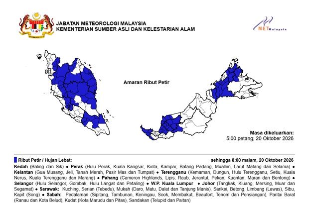 MetMalaysia: Thunderstorms, severe weather expected in nine states and KL until 8pm on Oct 20
The Star MetMalaysia: Thunderstorms, severe weather expected in nine states and KL until 8pm on Oct 20 PETALING JAYA: Thunderstorms and heavy rains are expected in several states in the country until 8pm on Tuesday (Oct…
-
 Super El Niño 2026: Moving in the Winter in Cleveland
Northeast Ohio may be heading into a winter unlike any most residents have lived through. In its September 10 update, NOAA's Climate Prediction Center said El Niño is strengthening, with a greater than 90% chance of a…
- First Alert Daily: Tracking a chill in the October morning air
Tuesday morning could be the coolest start to the day for Tallahassee since early May. Meteorologist Cameron Aaron is breaking down how long these cooler temperatures will stick around. TALLAHASSEE, Fla. (WCTV)…
-
 FIRST ALERT FORECAST: Nice weather continues this week though fire danger will remain high
LAKE CHARLES, La. (KPLC) - Comfortable weather will continue throughout the week, but so will the drought and elevated fire danger. Monday morning will see temperatures drop into the upper 40s to low 50s away from the…
- Sunday, Oct. 18, 2026: Spotty shower, temps in the 70s
Download our free KRGV FIRST WARN 5 Weather app for the latest updates right on your phone. Sunday, Oct. 18, 2026: Spotty shower, temps in the 70s You can also follow our KRGV First Warn 5 Weather team on Facebook and…
- Break out the jacket: Cool mornings on tap 🧥
TALLAHASSEE, Fla. (WCTV) - We’re tracking lows in the upper-40s and low-50s for the upcoming work week. Tuesday morning could be the coolest start to the day since early May. Meteorologist Cameron Aaron has the latest…
-
 Chilly mornings and comfy afternoons
WCPO 9 Cincinnati is a WCPO 9 First Warning meteorologist. Want to see Cameron report the weather from your community? Reach out to him at [email protected] This morning is a 9 First Warning Weather Alert Day as…
- Our fall feel sticks around 🍂
TALLAHASSEE, Fla. (WCTV) - Could we see low temperatures in the 40s in the coming days? Meteorologist Cameron Aaron has the answer. Tonight Through Sunday Night A dry, clear and breezy night is ahead across the region…
-
 Thunderstorms and heavy rain forecast for 13 states, KL and Putrajaya until 5pm
PETALING JAYA: The Malaysian Meteorological Department (MetMalaysia) has issued a warning of thunderstorms, heavy rain and strong winds across 13 states and two Federal Territories, effective until 5pm on Saturday (Oct…
-
 Drought, heat wave leaves Mount Hood barren by early fall
On Oct. 8, 2026, the Palmer Snowfield below the Palmer Express chairlift was almost completely bare. Timber Lodge had to close the lift on July 19, its earliest closing day. Cameron Nielsen / OPB A towering white Mount…
Air quality
Acceptable. Unusually sensitive people should consider limiting prolonged outdoor exertion.
St. Joseph, MO reporting area · 2 hrs ago. Data from AirNow (EPA and its state, local and tribal partners); preliminary and subject to change.
Sun & moon
Almanac
MonthlyCameron, records since 2005. Normals 1991–2020. Data from NOAA's Regional Climate Centers (ACIS).
Nearby
- Saint Joseph 52 km
- Liberty 56 km
- Excelsior Springs 44 km
- Chillicothe 60 km
- Kearney 42 km
- Smithville 48 km
- Richmond 55 km
- Savannah 55 km
- Country Club Village 51 km
- Lawson 33 km
- Plattsburg 25 km
- Lathrop 22 km
Forecasters' discussion
From the National Weather Service office in EAX, issued 7 hrs ago
Key Messages
- A few sprinkles are possible (10-15%) through mid-morning, but meaningful precipitation is not expected.
- Above normal temperatures and dry conditions expected through this weekend.
- Rain chances return Monday (20-50%).
Discussion
Issued at 242 AM CDT Wed Oct 21 2026
Early this morning, a upper level shortwave is rounding the upper level ridge over the Plains. This shortwave is moving into the local area providing enough lift to produce weak returns on radar moving into the eastern Kansas and western Missouri. These returns are falling into dry air below 10kft which is keeping any precipitation relegated to brief very light sprinkles. These brief sprinkles may continue until mid-morning when the upper shortwave will weaken and surface high pressure builds into the area from the east. Despite surface high pressure providing weak mixing today, height rises across the area due to the upper level ridge becoming more amplified will drive highs into the low to mid 70s. Continued height rises are expected Thursday as the upper level ridge axis moves from the central Plains to the eastern Plains in response to a upper level trough moving into the California coast. This will drive highs into the mid to upper 70s. Friday and Saturday, the upper level ridge axis moves directly over the area providing further height rises coupled with modest WAA. This will aid in highs rising into the mid 70 to near 80.
By Sunday, the aforementioned upper level trough will move from the Great Basin to the Eastern Rockies weakening as it does. This will force an attendant cold front into the Plains on Sunday. The local area will remain in the warm sector ahead of the front with highs again in the 70s. Monday, weak trough will move into the central Plains finally forcing the cold front into the CWA providing the next chance for precipitation. The upper trough will then move through the region on Monday night continuing shower chances as the front is forcing through the CWA. Temperatures in Monday will range from the lower 60s to lower 70s. Surface high pressure will build into the area behind the cold front cooling highs to near seasonal normals in the upper 50s to mid 60s.
Aviation
Issued at 605 AM CDT Wed Oct 21 2026
VFR conds will prevail thru the pd with bkn mid-lvl clouds around 10kft fcst thru 16Z-17Z. Aft 16Z-17Z...sct high clouds are expected. Winds will generally be light out of the south thru the pd at 6kts or less.
Eax Watches
MO...None. KS...None.
Forecasts, observations and alerts in the United States come from the National Weather Service (NOAA); radar from NOAA's Multi-Radar Multi-Sensor system; satellite imagery from NASA's Global Imagery Browse Services (GIBS) and NOAA's GOES satellites; the map from the U.S. Geological Survey's National Map; air quality from AirNow (EPA and its partners); hurricane information from the National Hurricane Center; climate normals and records from NOAA's Regional Climate Centers (ACIS). Forecasts outside the United States and the UV index: MET Norway (CC BY 4.0); observations outside the U.S.: airport reports via NOAA's Aviation Weather Center. Place names: GeoNames (CC BY 4.0). Data are copied on a schedule and may lag the sources; for warnings that affect your safety, follow your local National Weather Service office and emergency officials. Weather news is drawn from the 4Conservative index and reflects what the press published. Terms of use.