Install
Pagbilao, Calabarzon, Philippines Weather
Current conditions
Forecast for this hour (no station report in the last two hours)
Forecast
10-day-
Tuesday Night
Partly cloudy. Low 25°.
-
Wednesday
Light showers. High 33°. Precipitation 0.9 mm for the day.
-
Wednesday Night
Fog. Low 23°. Precipitation 0.9 mm for the day.
MET Norway forecast updated 2 hrs ago.
Hourly
Hourly forecast- Now25°
- 23:0025°
- Wed00:0025°
- 01:0025°
- 02:0025°
- 03:0024°
- 04:0024°
- 05:0023°
- 06:0023°
- 07:0026°
- 08:0028°
- 09:0030°
- 10:0031°
- 11:0032°0.2
- 12:0033°0.2
- 13:0032°0.3
- 14:0032°0.2
- 15:0031°
- 16:0030°
- 17:0028°
- 18:0027°
- 19:0027°
- 20:0026°
- 21:0026°
10-day forecast
DetailsRadar
Full mapWeather news near Pagbilao
More weather news- San Jose Sizzles To 89 Degrees Friday As Bay Area Fire Fears Rise
The National Weather Service forecast calls for sunny, dry conditions Wednesday, with light southeast winds in the morning and a breeze reaching about 8 mph later in the day. Wednesday night should stay clear, with…
-
 Recently chilly Bay Area about to get warm again
The Bay Area’s back-and-forth pendulum of hotter weather followed by a significant cooldown followed by more heat followed by more cool is about to swing back to the warmer end of the scale. But this heat-up might be…
-
 Wind signal no. 1 up in 4 provinces as super typhoon Rosal enters PAR | ABS-CBN News
Wind signal no. 1 up in 4 provinces as super typhoon Rosal enters PAR ABS-CBN Wind signal no. 1 up in 4 provinces as super typhoon Rosal enters PAR Your go-to source for the latest news, entertainment highlights…
- Super Typhoon Champi enters PAR, prompts Signal No. 1 in five areas — PAGASA
Super Typhoon Champi has entered the Philippine Area of Responsibility (PAR), prompting the hoisting of storm signal No. 1 over five areas in Luzon, with potentially life-threatening winds, according to the Philippine…
-
 Bus Stop Forecast: Rob has the weather for this morning’s commute - 10/19/26
The WCTV First Alert Weather team will keep you prepared for your daily commute. Today, the cool and breezy air is here to stay but temperatures will rise. Bus Stop Forecast: Rob has the weather for this morning’s…
-
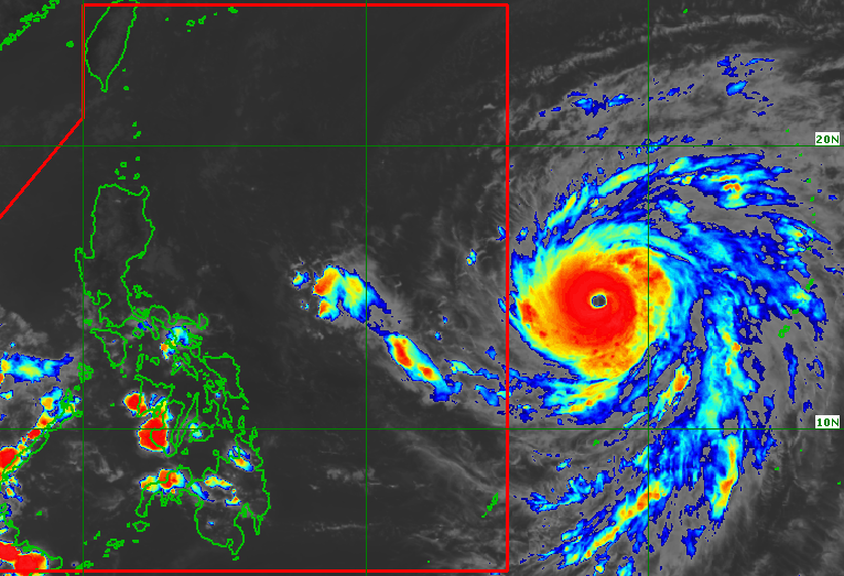 Champi now a super typhoon again ahead of entry into PAR
CHAMPI. Satellite image of Super Typhoon Champi outside the Philippine Area of Responsibility as of October 19, 2026, 4 pm. MANILA, Philippines – Champi re-intensified into a super typhoon on Monday afternoon, October…
- Champi re-intensifies as super typhoon
CHAMPI has regained super typhoon status and may prompt the hoisting of storm signal No. 3 over parts of Luzon, bringing potentially life-threatening winds, the Philippine Atmospheric, Geophysical and Astronomical…
-
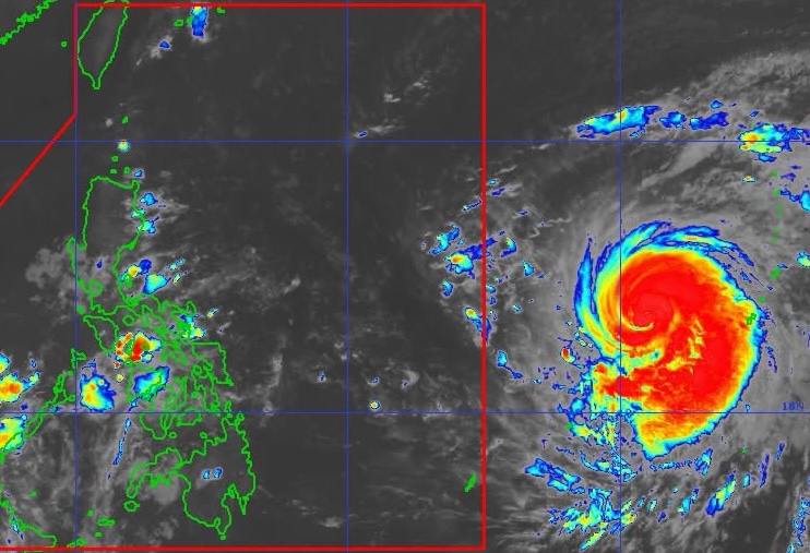 Champi weakens outside PAR but likely to re-intensify into super typhoon
CHAMPI. Satellite image of Typhoon Champi outside the Philippine Area of Responsibility as of October 19, 2026, 10:40 am. MANILA, Philippines – The tropical cyclone with the international name Champi weakened into a…
-
 Champi to re-intensify into super typhoon before PAR entry Tuesday | ABS-CBN News
Champi to re-intensify into super typhoon before PAR entry Tuesday ABS-CBN Champi to re-intensify into super typhoon before PAR entry Tuesday Your go-to source for the latest news, entertainment highlights, exclusive…
-
 Champi weakens to typhoon, but may regain strength before entering PAR
MANILA, Philippines — From a supertyphoon, Champi has weakened into a typhoon, but may regain supertyphoon strength before entering the Philippine area of responsibility (PAR) on Tuesday, Oct. 20, according to the…
Sun & moon
Nearby
Forecasts, observations and alerts in the United States come from the National Weather Service (NOAA); radar from NOAA's Multi-Radar Multi-Sensor system; satellite imagery from NASA's Global Imagery Browse Services (GIBS) and NOAA's GOES satellites; the map from the U.S. Geological Survey's National Map; air quality from AirNow (EPA and its partners); hurricane information from the National Hurricane Center; climate normals and records from NOAA's Regional Climate Centers (ACIS). Forecasts outside the United States and the UV index: MET Norway (CC BY 4.0); observations outside the U.S.: airport reports via NOAA's Aviation Weather Center. Place names: GeoNames (CC BY 4.0). Data are copied on a schedule and may lag the sources; for warnings that affect your safety, follow your local National Weather Service office and emergency officials. Weather news is drawn from the 4Conservative index and reflects what the press published. Terms of use.