Install
eMbangweni, Mpumalanga, South Africa Weather
Current conditions
Forecast for this hour (no station report in the last two hours)
Forecast
10-day-
Friday
Partly cloudy. High 21°. Precipitation 1.2 mm for the day.
-
Friday Night
Rain. Low 12°. Precipitation 1.2 mm for the day.
-
Saturday
Light rain. High 23°. Precipitation 0.9 mm for the day.
MET Norway forecast updated 16 hrs ago.
Hourly
Hourly forecast- Now20°
- 12:0021°
- 13:0021°
- 14:0021°
- 15:0021°
- 16:0019°
- 17:0017°
- 18:0016°
- 19:0015°
- 20:0015°
- 21:0014°0.2
- 22:0014°0.3
- 23:0014°0.6
- Sat00:0013°0.5
- 01:0013°0.2
- 02:0012°
- 03:0012°
- 04:0012°
- 05:0012°
- 06:0012°
- 07:0013°
- 08:0014°0.2
- 09:0016°
- 10:0018°
Daily forecast
DetailsRadar
Full mapWeather news in South Africa
More weather news-
 Throwback: The day a South African town recorded a scorching 48.4°C
Home » News » Weather » Throwback: The day a South African town recorded a scorching 48.4°C In October 2015, Vredendal recorded a scorching 48.4°C, marking one of South Africa’s most extreme heat events. On 27 October…
-
 One of the year’s best meteor showers peaks over South Africa tonight
Home » News » Weather » One of the year’s best meteor showers peaks over South Africa tonight A meteor shower linked to Halley’s Comet reaches its peak tonight, bringing a chance to spot bright streaks across South…
-
 Limpopo heatwave: Will temperatures ease this weekend?
Home » News » Weather » Limpopo heatwave: Will temperatures ease this weekend? Limpopo’s heatwave advisory ends on Friday, but will temperatures drop this weekend? Find out what the forecast shows. Residents in parts of…
-
 WEATHER TODAY: Heat wave for Lephalale and Thabazimbi, Rustenburg up to 34°C
Home » News » Weather » WEATHER TODAY: Heat wave for Lephalale and Thabazimbi, Rustenburg up to 34°C Weather for Friday: Slight rain and drizzle for Durban, Gqeberha and Mthatha, while Cape Town stays dry under high…
-
 Gauteng weather: Very high UV levels expected on Thursday
Home » News » Weather » Gauteng weather: Very high UV levels expected on Thursday Gauteng faces very high UV levels on Thursday. Find out when sun exposure poses the greatest risk and how to protect yourself. Gauteng…
-
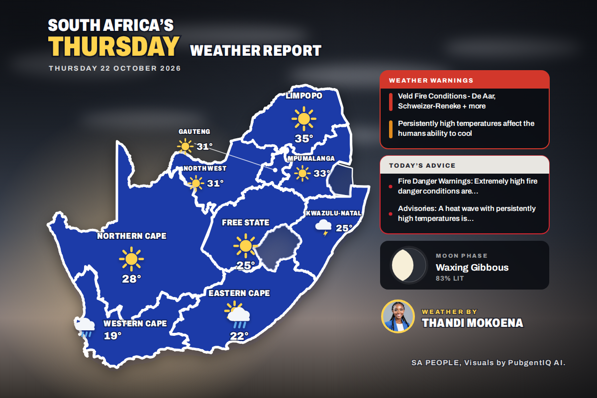 Here is today’s weather by province: Blouberg and Alldays under weather advisory on hot Limpopo day
Home » Here is today’s weather by province: Blouberg and Alldays under weather advisory on hot Limpopo day Polokwane tops the heat at 35°C and Bloemfontein wakes to a chilly 9°C, while SAWS advisories also cover…
-
 WEATHER: Pretoria to hit 35°C on Friday as Johannesburg reaches 31°C and Cape Town stays mild
22 October 2026 06:21 Sundowns treat Williete SC clash as a final in CAF Champions League battle 22 October 2026 06:07 SAPS must ensure elections are conducted in a safe environment: Cachalia 22 October 2026 06:06…
-
 Weather: Brace for afternoon showers and thundershowers in KZN
Home » News » Weather » Weather: Brace for afternoon showers and thundershowers in KZN Wondering what the weather will be like this Thursday– Here’s the outlook for KwaZulu-Natal, Free State and North West Here is what…
-
 Brace for rain and strong winds in Western Cape
Home » News » Weather » Brace for rain and strong winds in Western Cape The Western Cape can expect rain and cooler weather on Wednesday, while several inland provinces remain hot and windy. The Western Cape can expect…
- Today's weather: Hot, windy, extreme fire danger and rain forecast for Wednesday
Severe storms threaten Durban as emergency teams go on alert South Africa is bracing for a mix of hot, windy and rainy weather on Wednesday, with the South African Weather Service (SAWS) warning of extremely high fire…
Sun & moon
Nearby
Forecasts, observations and alerts in the United States come from the National Weather Service (NOAA); radar from NOAA's Multi-Radar Multi-Sensor system; satellite imagery from NASA's Global Imagery Browse Services (GIBS) and NOAA's GOES satellites; the map from the U.S. Geological Survey's National Map; air quality from AirNow (EPA and its partners); hurricane information from the National Hurricane Center; climate normals and records from NOAA's Regional Climate Centers (ACIS). Forecasts outside the United States and the UV index: MET Norway (CC BY 4.0); observations outside the U.S.: airport reports via NOAA's Aviation Weather Center. Place names: GeoNames (CC BY 4.0). Data are copied on a schedule and may lag the sources; for warnings that affect your safety, follow your local National Weather Service office and emergency officials. Weather news is drawn from the 4Conservative index and reflects what the press published. Terms of use.