Install
Cai Lậy, Dong Thap, Vietnam Weather
Current conditions
Forecast for this hour (no station report in the last two hours)
Forecast
10-day-
Wednesday
Heavy rain. High 34°. Precipitation 10.0 mm for the day.
-
Wednesday Night
Showers. Low 25°. Precipitation 10.0 mm for the day.
-
Thursday
Heavy showers. High 33°. Precipitation 7.8 mm for the day.
MET Norway forecast updated 3 hrs ago.
Hourly
Hourly forecast- Now26°
- 01:0026°
- 02:0025°
- 03:0025°
- 04:0025°
- 05:0025°
- 06:0025°
- 07:0027°
- 08:0029°
- 09:0030°
- 10:0032°
- 11:0033°
- 12:0034°0.4
- 13:0032°6.3
- 14:0028°1.6
- 15:0029°0.4
- 16:0029°0.3
- 17:0027°
- 18:0026°
- 19:0026°0.9
- 20:0025°
- 21:0025°
- 22:0025°
- 23:0026°
Daily forecast
DetailsRadar
Full mapWeather news near Cai Lậy
More weather news-
 Rhybudd melyn am wyntoedd cryfion yn y de a'r canolbarth
Daw'r rhybudd i rym am 00:00 fore Gwener Mae'r Swyddfa Dywydd wedi cyhoeddi rhybudd melyn am wyntoedd cryfion ar gyfer rhannau helaeth o ganolbarth a de Cymru. Daw'r rhybudd i rym am 00:00 ddydd Gwener a bydd yn dod i…
-
 Cloud Seeding Impractical for Cebu's El Niño Response
CLOUD seeding may not be a practical solution for Cebu as it braces for the effects of El Niño, primarily because the province’s narrow geography makes it difficult to guarantee that induced rain will actually fall over…
-
 LOCAL SPORTS SCENE HIT AS HAZY CONDITIONS PERSIST
As hazy conditions continue to plague Singapore, many in the local sports scene have been affected, with national sports associations (NSAs), clubs and sports facilities forced to make adjustments to cope with the…
-
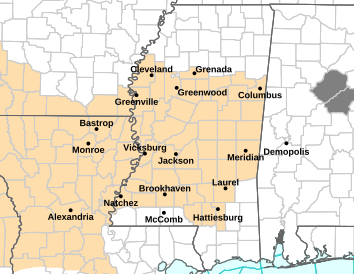 Fire Weather Watch for This Area Friday
Kicks96news.com - Central Mississippi News 24/7 FIRE WEATHER WATCH shown in tan on map above The National Weather Service has issued a fire weather watch for much of Mississippi including the local area, in effect from…
-
 Will Phoenix see rain this weekend? Here’s the latest forecast
The Valley starts with a refreshing cool-down, as Sky Harbor fell to 58 degrees Wednesday morning — 8 degrees below average. Highs reach the upper 70s before rebounding into the upper 80s Thursday and Friday. Gusts…
-
 Attendance at pools and stadiums falls 12% as haze curbs outdoor exercise
Warren Golf and Country Club in Chua Chu Kang has also observed a 20 per cent drop in weekly attendance due to the haze. SINGAPORE: With Singapore shrouded in persistent haze and air quality readings remaining in the…
-
 WMO Recognizes Vietnam's El Niño Response Initiative
Mirage News The 47th Annual Meeting of the ASEAN Sub-Committee on Meteorology and Geophysics opened in Da Nang. The Viet Nam Meteorological and Hydrological Administration, under the Ministry of Agriculture and…
-
 Today's weather (October 20th): Fog in the early morning in Northern Vietnam.
VHO - According to the National Center for Meteorological and Hydrological Forecasting, on October 20th, Northern and Central Vietnam will experience sunny weather, with some areas having fog in the early morning…
- Today's weather (October 20th): Southern Vietnam will experience thunderstorms in the afternoon, while Northern Vietnam will have sunny weather.
Today, October 20th, the southern provinces will experience showers to heavy rain in the late afternoon and evening, with strong winds and thunderstorms at sea; ships should exercise caution. According to the National…
- Northern Vietnam experiences hot weather, while Central and Southern Vietnam have areas with heavy rainfall exceeding 70mm.
VTV.vn - Today (October 20th), Northern Vietnam continues to experience sunny and hot weather. Meanwhile, Central and Southern Vietnam will have thunderstorms, with some areas receiving heavy rain exceeding 70mm. Other…
Sun & moon
Nearby
Forecasts, observations and alerts in the United States come from the National Weather Service (NOAA); radar from NOAA's Multi-Radar Multi-Sensor system; satellite imagery from NASA's Global Imagery Browse Services (GIBS) and NOAA's GOES satellites; the map from the U.S. Geological Survey's National Map; air quality from AirNow (EPA and its partners); hurricane information from the National Hurricane Center; climate normals and records from NOAA's Regional Climate Centers (ACIS). Forecasts outside the United States and the UV index: MET Norway (CC BY 4.0); observations outside the U.S.: airport reports via NOAA's Aviation Weather Center. Place names: GeoNames (CC BY 4.0). Data are copied on a schedule and may lag the sources; for warnings that affect your safety, follow your local National Weather Service office and emergency officials. Weather news is drawn from the 4Conservative index and reflects what the press published. Terms of use.