Install
Laramie, WY Weather
Current conditions
Forecast for this hour (no station report in the last two hours)
Forecast
10-day-
Sunday
Patchy fog before 8am, then a chance of rain showers. Partly sunny. High near 52, with temperatures falling to around 49 in the afternoon. East southeast wind 10 to 15 mph. Chance of precipitation is 30%.
-
Sunday Night
Rain showers before midnight, then rain and snow showers likely between midnight and 3am, then a chance of rain and snow showers. Cloudy, with a low around 34. South southeast wind 5 to 10 mph. Chance of precipitation is 80%.
-
Monday
A chance of rain and snow showers before noon. Partly sunny, with a high near 52. Southwest wind around 5 mph. Chance of precipitation is 40%.
National Weather Service forecast updated 17 hrs ago.
Hourly
Hourly forecast- Now34°14%
- 7 AM32°14%
- 8 AM33°14%
- 9 AM37°14%
- 10 AM41°14%
- 11 AM45°14%
- 12 PM49°14%
- 1 PM51°14%
- 2 PM52°14%
- 3 PM52°25%
- 4 PM50°16%
- 5 PM49°27%
- 6 PM46°23%
- 7 PM45°29%
- 8 PM43°65%
- 9 PM42°71%
- 10 PM41°81%
- 11 PM41°81%
- Mon12 AM40°66%
- 1 AM39°66%
- 2 AM37°66%
- 3 AM36°30%
- 4 AM35°30%
- 5 AM34°30%
Daily forecast
Details- SatOct 24Partly Sunny15%32°47°
- TodayOct 25Patchy Fog then Chance Rain Showers81%34°52°
- MonOct 26Chance Rain And Snow Showers then Partly Sunny37%32°52°
- TueOct 27Sunny31°56°
- WedOct 28Sunny33°59°
- ThuOct 29Mostly Sunny36°61°
- FriOct 30Partly Sunny11%36°60°
- SatOct 31Partly cloudy0.02 in35°56°
- SunNov 1Cloudy0.06 in32°53°
Days after the National Weather Service's seven are MET Norway's outlook, a computer model with no forecaster's review.
Radar
Full mapWeather news near Laramie
More weather news-
 Mild, sunny weather expected for Cheyenne area this weekend; wind warnings issued for regional corridors
Cap City News Over 1 million readers this year! CHEYENNE, Wyo. — Dry, mild weather and sunny skies are set to dominate Cheyenne this weekend, as an upper-level high-pressure ridge builds across southeastern Wyoming…
-
 A strong-to-very-strong El Niño will impact winter 2026-2027
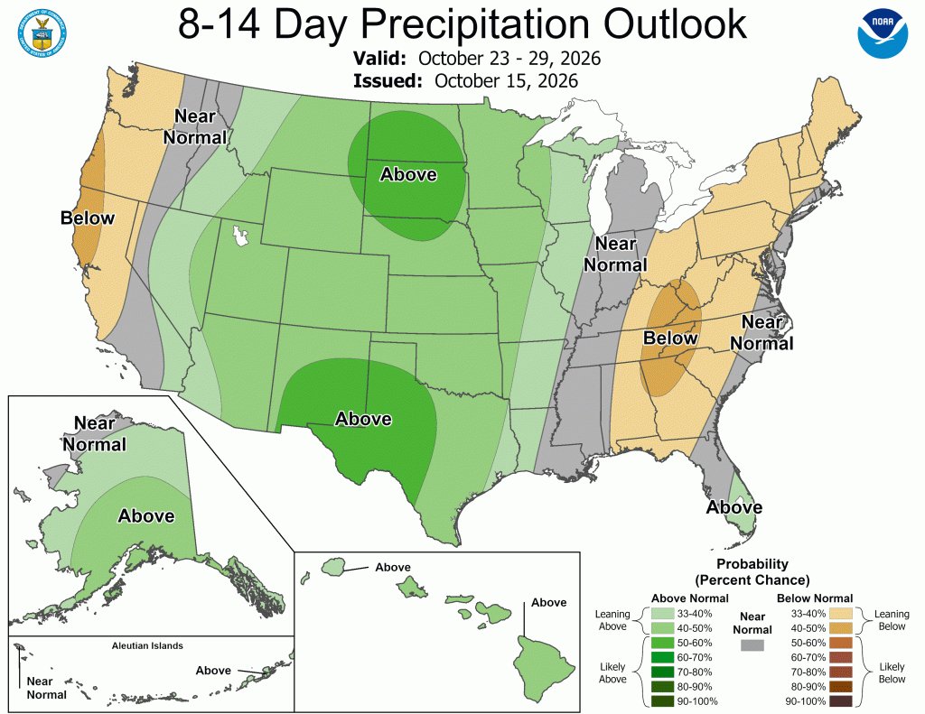
NewsNews | Oct 16, 2026 In the short-term forecast (eight to 14 day outlook) there is a risk of heavy snow from Colorado northward into Wyoming and southern Montana between Oct. 22 to 28. During that same period, strong…
-
 High wind watch issued for southeast Wyoming after freeze today
CHEYENNE, Wyo. — A high wind watch takes effect Saturday morning for wind-prone areas of southeast Wyoming as meteorologists expect wind gusts reaching 60 mph. The National Weather Service in Cheyenne issued the watch…
- How much rain fell in Minnesota on Thursday, Oct. 15?
After a bone-dry start to October for much of the state, Minnesota finally welcomed some rain on Thursday. Unlike the short, heavy bursts typically brought by summer storms, Thursday was a decidedly fall-like day of…
- Freeze watch issued in Twin Cities, southern half of Minnesota with temps set to plunge
The first freeze watch of the season has been issued for the Twin Cities, with overnight temperatures set to plunge in the coming days. The watch has been put into effect for much of the southern half of Minnesota from…
-
 Cheyenne faces morning snow, hard freeze before weekend warmup
CHEYENNE, Wyo. — Cheyenne will see morning snow and rain give way to below freezing temperatures tonight, bringing a growing-season-ending freeze to southeast Wyoming. Rain and snow will continue across the capital city…
-
 Southeast Wyoming Freeze Watch Issued, Laramie Faces Weather Advisory
Travel disruptions expected as snow accumulates near the I-80 Summit, Freeze watch issued KGAB Southeast Wyoming Freeze Watch Issued, Laramie Faces Weather Advisory The Cheyenne Office of the National Weather Service…
-
 Dangerous Freeze Watch Warning Issued for Massive Area of Nebraska, Wyoming and Colorado
A Freeze Watch is in effect from late Thursday night through Friday morning for the Denver metro area, Colorado’s eastern plains, southeast and central Wyoming, and the Nebraska Panhandle, with lows in the 20s possible…
-
 Rain, snow arrive in Cheyenne, heralding season-ending freeze
CHEYENNE, Wyo. — Rain across Cheyenne will shift into a slushy mix of rain and snow tonight as an incoming Pacific storm system brings colder air and gusty winds to southeast Wyoming. The capital city can expect rain…
- Arizona Braces for Wind Gusts Up to 60 MPH Thursday and Friday
According to the Arizona Weatherman, from Thursday into Friday, 15–16 Oct 2026, expect very strong, gusty winds to impact parts of the state. These winds may bring blowing dust and difficult driving conditions to the…
Air quality
Air quality is satisfactory, and air pollution poses little or no risk.
Laramie, WY reporting area · 1 hr ago. Data from AirNow (EPA and its state, local and tribal partners); preliminary and subject to change.
Sun & moon
Almanac
MonthlyLaramie Ap, records since 1948. Normals 1991–2020. Data from NOAA's Regional Climate Centers (ACIS).
Forecasts, observations and alerts in the United States come from the National Weather Service (NOAA); radar from NOAA's Multi-Radar Multi-Sensor system; satellite imagery from NASA's Global Imagery Browse Services (GIBS) and NOAA's GOES satellites; the map from the U.S. Geological Survey's National Map; air quality from AirNow (EPA and its partners); hurricane information from the National Hurricane Center; climate normals and records from NOAA's Regional Climate Centers (ACIS). Forecasts outside the United States and the UV index: MET Norway (CC BY 4.0); observations outside the U.S.: airport reports via NOAA's Aviation Weather Center. Place names: GeoNames (CC BY 4.0). Data are copied on a schedule and may lag the sources; for warnings that affect your safety, follow your local National Weather Service office and emergency officials. Weather news is drawn from the 4Conservative index and reflects what the press published. Terms of use.