Install
Takoma Park, MD Weather
Current conditions
Observed at Washington/Reagan National Airport, DC · 46 min ago
Forecast
10-day-
Sunday
Sunny, with a high near 64.
-
Sunday Night
Mostly clear, with a low around 46.
-
Monday
Sunny, with a high near 69.
National Weather Service forecast updated 4 days ago.
Hourly
Hourly forecast- Now62°
- 3 PM64°
- 4 PM64°
- 5 PM64°
- 6 PM62°
- 7 PM58°
- 8 PM55°
- 9 PM53°
- 10 PM51°
- 11 PM50°
- Mon12 AM49°
- 1 AM49°
- 2 AM49°
- 3 AM48°
- 4 AM48°
- 5 AM47°
- 6 AM46°
- 7 AM46°
- 8 AM47°
- 9 AM50°
- 10 AM53°
- 11 AM57°
- 12 PM61°
- 1 PM64°
10-day forecast
Details- TonightOct 20Clear48°
- WedOct 21Sunny45°65°
- ThuOct 22Sunny46°67°
- FriOct 23Sunny40°60°
- SatOct 24Sunny43°61°
- TodayOct 25Sunny46°64°
- MonOct 26Sunny50°69°
- TueOct 27Mostly Sunny66°
- WedOct 28Cloudy52°65°
- ThuOct 29Partly cloudy44°58°
Days after the National Weather Service's seven are MET Norway's outlook, a computer model with no forecaster's review.
Radar
Full mapWeather news near Takoma Park
More weather news-
 Thanksgiving Weather Forecast 2026: What to Expect Across the U.S.
Thanksgiving is a time for family, food, gratitude—and for many Americans, travel. Whether you’re driving across town or flying across the country, the weather can shape your plans in a big way. So what does the…
-
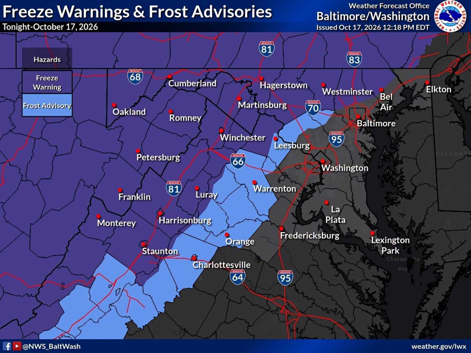 Frost Advisory and Freeze Warnings in Effect Across Parts of Maryland And Northern Virginia
A Frost Advisory remains in effect for northwestern Montgomery County until 9am Sunday, October 18, as temperatures are expected to fall into the low-to-mid 30s overnight. A Freeze Warning is in effect for some…
- Baltimore Basks in Sunny Sunday Warm-Up After October Chill
Baltimore is waking up to a crisp, clear Sunday, with temperatures near 41 degrees early and sunshine building toward a high around 62. North winds near 7 mph will keep the morning feeling brisk, but the afternoon…
- South Philadelphia Gets a Cold Sunday After Friday’s Storm Watch
South Philadelphia residents heading to the Eagles game at 1 p.m. Sunday should expect sunshine and temperatures in the 50s, with the 40s possible for morning tailgaters, FOX 29 Philadelphia reported. The chill follows…
-
 Freeze the day: DC region braces for coldest morning of the season
The D.C. region is in for its coldest morning of the season Sunday, with frost advisories and freeze warnings in effect across parts of Maryland and Virginia as temperatures tumble overnight. The National Weather…
-
 New Nor'easter Forms Off Atlantic Coast: How It Could Impact MD
Maryland's coast may see another round of rough weather as a new nor'easter takes shape, threatening strong winds, beach erosion and coastal flooding in parts of the state next week. Just three weeks after a powerful…
-
 DC Weather: Coldest air since mid-April sweeps into DC Saturday
by Storm Alert Weather WASHINGTON(7News) — A sharp cooldown arrives Saturday. Scattered morning showers are possible, followed by a few breaks of sunshine in the afternoon. Highs will only reach the mid-50s, and north…
-
 Severe Thunderstorm Watch: Washington DC, Maryland And Northern Virginia Face Threat Of Damaging Winds And Heavy Rain; Check Affected Areas And Forecast Timing
Zaini is Editor at The Sunday Guardian. She focuses on geopolitics, defence, international affairs, and breaking news coverage. She has worked in fast-paced newsrooms, including WION, Republic Media Network, India Today…
-
 Dangerous Freeze Watch Issued for Maryland, DC, West Virginia and New Jersey as Temperatures Plummet
Freeze Watches are in effect from late Saturday night through Sunday morning across western Maryland, West Virginia and northern New Jersey, with lows in the upper 20s to low 30s possible. A strong cold front moves…
-
 WEATHER ALERT: Severe Thunderstorm Watch For Southern Maryland Until 8pm
SOUTHERN MARYLAND — The National Weather Service Baltimore/Washington has issued a Severe Thunderstorm Watch that includes Calvert, Charles and St. Mary’s counties through 8 p.m. Friday, Oct. 16. The Severe Thunderstorm…
Air quality
Acceptable. Unusually sensitive people should consider limiting prolonged outdoor exertion.
Forecast
- SunModerate (53)
- MonGood (50)
- TueGood (44)
Northern Virginia and DC, DC reporting area · 2 hrs ago. Data from AirNow (EPA and its state, local and tribal partners); preliminary and subject to change.
Sun & moon
Almanac
MonthlyWashington Reagan National Airport, records since 1941. Normals 1991–2020. Data from NOAA's Regional Climate Centers (ACIS).
Nearby
- Washington 10 km
- Arlington 14 km
- Alexandria 20 km
- Columbia 33 km
- Germantown 31 km
- Silver Spring 2 km
- Centreville 40 km
- Waldorf 40 km
- Glen Burnie 39 km
- Gaithersburg 25 km
- Rockville 17 km
- Ellicott City 37 km
Forecasters' discussion
From the National Weather Service office in LWX, issued 3 hrs ago
What Has Changed
The growing season ended for Frederick MD and western Loudoun Counties. Otherwise little to no change needed to the forecast this morning.
Key Messages
- 1) Below normal low temperatures give way to a warming trend early this week.
- 2) Above normal temperatures and dry conditions continue through the end of the week.
Discussion
KEY MESSAGE 1...Below normal low temperatures give way to a warming trend early this week.
High pressure will drift southwest through Monday. As a result, expect a continuation of frost and freeze conditions tonight with seasonable temperatures during the daylight hours.
After the chilly start, temperatures will rebound well into the 60s for much of the area this afternoon. Some stratocumulus are possible at times, but may ultimately be thin and transient.
As the high drifts southwest tonight, low-level flow will turn westerly allowing for less of a marine influence. This should set us up for one more good radiational cooling night before temperatures warm under return flow early in the workweek. Tonight will be more of a ridge- valley split type of night with cooler conditions in the valleys/cold pockets/locations along and east of I-95 compared to the ridge tops given the sharp surface inversion/decoupling.
Only minor changes have been made to the previous min temperature forecasts, which are near or below the coldest guidance which performs best in radiational cooling (MOS, NBM 10th percentile and Canadian Regional).
Expect temperatures to rise above normal (upper 60s to lower 70s) by Monday afternoon as the warming airmass mixes to the surface. Minimal cloud cover and light winds will remain persistent.
Aviation
Expect VFR conditions today with some stratocu possible. NAM and related guidance continues to show more widespread low CIGS and fog late tonight into early Monday morning, with at least some hint of this in other guidance and forecast soundings.
Winds will be light out of the NE this morning shifting to SE this afternoon, then W overnight. W/NW winds AOB 10 kts Monday.
P6SM SKC with light and variable winds as high pressure dominates. A dry cold front will cross the area late Monday night with winds shifting to NW Tuesday.
Forecasts, observations and alerts in the United States come from the National Weather Service (NOAA); radar from NOAA's Multi-Radar Multi-Sensor system; satellite imagery from NASA's Global Imagery Browse Services (GIBS) and NOAA's GOES satellites; the map from the U.S. Geological Survey's National Map; air quality from AirNow (EPA and its partners); hurricane information from the National Hurricane Center; climate normals and records from NOAA's Regional Climate Centers (ACIS). Forecasts outside the United States and the UV index: MET Norway (CC BY 4.0); observations outside the U.S.: airport reports via NOAA's Aviation Weather Center. Place names: GeoNames (CC BY 4.0). Data are copied on a schedule and may lag the sources; for warnings that affect your safety, follow your local National Weather Service office and emergency officials. Weather news is drawn from the 4Conservative index and reflects what the press published. Terms of use. How to use Weather