Install
Gardner, MA Weather
Current conditions
Observed at Fitchburg, Fitchburg Municipal Airport · 31 min ago
Forecast
10-day-
Friday Night
Areas of frost after 9pm. Mostly clear, with a low around 27. North wind around 3 mph.
-
Saturday
Areas of frost before 10am. Sunny, with a high near 57. Northwest wind around 5 mph.
-
Saturday Night
Areas of frost after 10pm. Clear, with a low around 29. Northwest wind around 2 mph.
National Weather Service forecast updated 1 day ago.
Hourly
Hourly forecast- Now48°
- 7 PM43°
- 8 PM38°
- 9 PM35°
- 10 PM33°
- 11 PM32°
- Sat12 AM31°
- 1 AM30°
- 2 AM29°
- 3 AM29°
- 4 AM28°
- 5 AM28°
- 6 AM27°
- 7 AM27°
- 8 AM29°
- 9 AM35°
- 10 AM42°
- 11 AM49°
- 12 PM53°
- 1 PM55°
- 2 PM56°
- 3 PM57°
- 4 PM56°
- 5 PM55°
10-day forecast
Details- ThuOct 22Sunny31°60°
- TodayOct 23Areas Of Frost then Sunny27°53°
- SatOct 24Areas Of Frost then Sunny29°57°
- SunOct 25Areas Of Frost then Sunny33°61°
- MonOct 26Sunny40°64°
- TueOct 27Mostly Sunny34°57°
- WedOct 28Mostly Sunny36°54°
- ThuOct 29Partly cloudy38°60°
- FriOct 30Cloudy0.03 in35°53°
- SatOct 31Sunny32°52°
Days after the National Weather Service's seven are MET Norway's outlook, a computer model with no forecaster's review.
Radar
Full mapWeather news near Gardner
More weather news-
 WEATHER ALERT: Severe Thunderstorm warning in effect for parts of Mass.
A severe thunderstorm warning is in effect for some parts of Massachusetts. WEATHER ALERT: Severe Thunderstorm warning in effect for parts of Mass. A severe thunderstorm warning is in effect for some parts of…
-
 Rain and wind could disrupt your weekend plans in Massachusetts. See forecast
Rain showers, gusty winds, and temperatures dipping into the 40s and 30s could put a damper on outdoor weekend plans across Massachusetts. A low-pressure system is expected to bring rain Friday, Oct. 16, into early…
-
 Hard freeze coming to Massachusetts this weekend
Massachusetts is in for a stretch of quiet, dry weather, but forecasters say residents should prepare for a hard freeze this weekend as temperatures plunge well below freezing across much of the state. Post-Tropical…
-
 Dangerous Josephine Tropical Storm Triggers Warnings for Massachusetts and Rest of New England Coast
Subtropical Storm Josephine is racing northeast away from the U.S. East Coast, with Tropical Storm Warnings and a Hurricane Force Wind Warning in effect for offshore waters from the Mid-Atlantic to the Hague Line. The…
-
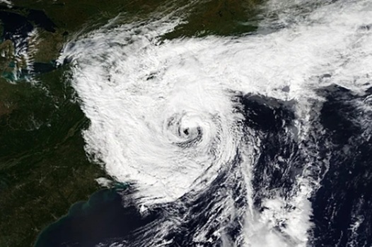 Deadly nor’easter dumps several inches of rain, strong winds in Massachusetts, Rhode Island and we aren’t done
A deadly slow-moving September nor’easter dumped several inches of rain on Fall River and the rest of southeastern Massachusetts over the weekend, according to the National Weather Service in Boston/Norton, while the…
-
 Dangerous Storm and Gale Warnings Issued for New York, Massachusetts, and the Rest of New England
The nor’easter’s strongest winds are shifting north, with Storm Warnings for waters south of New England, Gale Warnings for Massachusetts and Rhode Island waters, and coastal flooding on Long Island. The storm stays…
-
 Massachusetts Coast Braces for Strong Winds and Rough Seas
SuaraGarut.ID A powerful storm off the Massachusetts coast is expected to bring strong northeastern winds, rough seas and scattered showers on Wednesday, with the greatest impacts along the southern shoreline, according…
-
 Futurecast: Storm won’t directly hit Massachusetts, but its impacts will reach the coast
DEDHAM, Mass. — A distant nor’easter will keep Massachusetts breezy for the next several days, bringing rough surf and the potential for beach erosion before conditions gradually improve later this week. Closely…
- New England Could Face Another Fall Nor’easter – Maine, New Hampshire, & Massachusetts Take Note
Even though we normally think of Nor'easters as being a winter weather event, they can happen at any time during the year. In fact, we have already had a Nor'easter this year. It rolled through New England in September…
Air quality
Air quality is satisfactory, and air pollution poses little or no risk.
Forecast
- FriGood
- SatGood
Worcester, MA reporting area · 1 hr ago. Data from AirNow (EPA and its state, local and tribal partners); preliminary and subject to change.
Sun & moon
Almanac
MonthlyAshburnham, records since 1906. Normals 1991–2020. Data from NOAA's Regional Climate Centers (ACIS).
Nearby
- Worcester 38 km
- Lowell 56 km
- Nashua 48 km
- Framingham 58 km
- Framingham Center 55 km
- Leominster 20 km
- Fitchburg 16 km
- Billerica 60 km
- Amherst 49 km
- Marlborough 45 km
- Chelmsford 52 km
- Shrewsbury 39 km
Forecasters' discussion
From the National Weather Service office in BOX, issued 3 hrs ago
What Has Changed
No significant changes have been made to the forecast.
Key Messages
- Dry weather through the weekend with chilly/frosty nights and sunny/mild afternoons. Lows mainly in the 20s & 30s with highs in the upper 50s-lower 60s Sat and well into the 60s Sun.
- High pressure dominates through next week bringing plenty of sunny days and cooler nights.
Discussion
KEY MESSAGE 1...Dry weather through the weekend with chilly/frosty nights and sunny/mild afternoons. Lows mainly in the 20s & 30s with highs in the upper 50s-lower 60s Sat and well into the 60s Sun.
Distant offshore ocean storm will continue to lift NE and move further way losing its grip on our region. Lingering gusty winds across the Cape/Islands will diminish early this evening. Otherwise...a large 1035+ mb high pressure system will build overhead from the west through the weekend. The result will be mainly clear skies with chilly/frosty nights and mild sunny afternoons. Excellent radiational cooling conditions will allow for lows to drop into the 20s across the normally colder outlying locations with mainly 30s elsewhere. Meanwhile the Urban Heat Island of Boston will probably not drop below 40. Highs Sat will recover nicely into the upper 50s and lower 60s and well into the 60s Sun. Winds will also be rather light resulting in comfortable afternoons for the latter half of October.
KEY MESSAGE 2...High pressure dominates through next week, bringing plenty of sunny days and cooler nights.
Strong high pressure will prevail across New England for most of next week. Mostly sunny skies, dry conditions, and mostly calm winds are expected for a majority of the week, leading to good radiational cooling most nights. Day time temperatures are likely to remain in the upper 50s to mid 60s and nighttime temps generally in the low to mid 30s for most of southern New England.
Two exceptions to the pleasant conditions: a weak cold front drops into the region Tuesday, leading to some gusty winds Tuesday afternoon/evening along the Cape/Islands/SE MA and cooler temperatures behind the front on Wednesday (likely in the low 50s). This front looks to be moisture-starved and not likely to produce any showers at this time.
A second cold front looks to sweep through sometime Thursday night/early Friday morning, bringing some slightly increased PoPs (10-20) to portions of SNE.
Aviation
Forecaster Confidence Levels...
Low - less than 30 percent. Moderate - 30 to 60 percent. High - greater than 60 percent.
18z TAF Update...High confidence.
VFR conditions continue through the weekend. Lingering NE 20-30 knot wind gusts across the Cape/Islands diminish early this evening. Otherwise...sustained winds generally 10 knots or less through the weekend.
KBOS Terminal...High confidence in TAF.
KBDL Terminal...High confidence in TAF.
Forecasts, observations and alerts in the United States come from the National Weather Service (NOAA); radar from NOAA's Multi-Radar Multi-Sensor system; satellite imagery from NASA's Global Imagery Browse Services (GIBS) and NOAA's GOES satellites; the map from the U.S. Geological Survey's National Map; air quality from AirNow (EPA and its partners); hurricane information from the National Hurricane Center; climate normals and records from NOAA's Regional Climate Centers (ACIS). Forecasts outside the United States and the UV index: MET Norway (CC BY 4.0); observations outside the U.S.: airport reports via NOAA's Aviation Weather Center. Place names: GeoNames (CC BY 4.0). Data are copied on a schedule and may lag the sources; for warnings that affect your safety, follow your local National Weather Service office and emergency officials. Weather news is drawn from the 4Conservative index and reflects what the press published. Terms of use.