Install
Cedar Rapids, IA Weather
Current conditions
Observed at Cedar Rapids Airport · 43 min ago
Forecast
10-day-
Today
Sunny, with a high near 70. Southeast wind around 5 mph.
-
Tonight
Mostly clear, with a low around 45. Southeast wind 0 to 5 mph.
-
Wednesday
Sunny. High near 72, with temperatures falling to around 70 in the afternoon. South wind 0 to 5 mph.
National Weather Service forecast updated 1 hr ago.
Hourly
Hourly forecast- Now53°
- 11 AM60°
- 12 PM65°
- 1 PM68°
- 2 PM69°
- 3 PM70°
- 4 PM70°
- 5 PM69°
- 6 PM64°
- 7 PM60°
- 8 PM56°
- 9 PM54°
- 10 PM52°
- 11 PM52°
- Wed12 AM50°
- 1 AM48°
- 2 AM47°
- 3 AM46°
- 4 AM46°
- 5 AM45°
- 6 AM45°
- 7 AM45°
- 8 AM46°
- 9 AM51°
10-day forecast
Details- TodayOct 20Sunny45°70°
- WedOct 21Sunny48°72°
- ThuOct 22Sunny50°72°
- FriOct 23Mostly Sunny54°71°
- SatOct 24Partly Sunny54°71°
- SunOct 25Partly Sunny49°70°
- MonOct 26Mostly Sunny then Slight Chance Rain Showers15%45°64°
- TueOct 27Cloudy45°57°
- WedOct 28Cloudy0.02 in43°54°
- ThuOct 29Sunny39°52°
Days after the National Weather Service's seven are MET Norway's outlook, a computer model with no forecaster's review.
Radar
Full mapWeather news near Cedar Rapids
More weather news-
 Turning a bit warmer, but staying quiet
CEDAR RAPIDS, Iowa (KCRG) - More above-normal temperatures are on the way. A very quiet night looks pretty likely. Skies will be mostly clear, save for some of those scattered upper-level clouds we’ve seen from time to…
-
 Pleasant Fall Weather Continues
KCRG CEDAR RAPIDS, Iowa (KCRG) - Eastern Iowa is in for a fantastic stretch of fall weather through the workweek. Expect sunny skies and pleasant conditions today, with highs climbing into the upper 60s. Wednesday and…
-
 Mostly sunny, dry, and warming
Plenty of sunshine, dry weather, and gradually warming temperatures this week CEDAR RAPIDS, Iowa (KCRG) - We’ve got great weather headed our way this week! The rest of the week will bring similar conditions each day…
-
 Chilly this morning, warm week ahead
CEDAR RAPIDS, Iowa (KCRG) - Temperatures this morning are chilly, but will warm by this afternoon. Today brings sunny skies with highs in the mid 60s. South winds will be gusty, reaching 25-30 mph. Tonight will clear…
-
 Chilly overnight, steady warmup beginning
Another chilly night, steady warmup ahead KCRG CEDAR RAPIDS, Iowa (KCRG) - Temperatures are expected to take a steady upward trend over the next week. We’ll see another chilly night with overnight lows in the upper 30s…
-
 Frosty start, fall-like weekend
KCRG CEDAR RAPIDS, Iowa (KCRG) - Freeze and frost conditions are in effect through 9 AM, with a Freeze Warning in effect across eastern Iowa. Temperatures continue to climb early next week through Friday. Skies will…
-
 Frost, freeze likely by Saturday morning
CEDAR RAPIDS, Iowa (KCRG) - One night of freezing conditions looks likely for parts of eastern Iowa. If you’re headed out this evening, dress warmly. Temperatures will fall into the 40s and even though winds will turn…
-
 Dangerous Freeze Warnings Issued for Iowa, Wisconsin, Minnesota and Illinois as Temperatures Drop
Freeze Warnings take effect early Saturday across much of Iowa, Wisconsin, southeast and central Minnesota and northern Illinois, with lows as cold as 26 degrees expected. Seven National Weather Service offices issued…
-
 Freeze Warning for Eastern Iowa on Saturday morning with widespread frost expected
Police give an update on the Silver Rail Elementary School shooting, which left three children and a teacher dead. President Trump gives remarks at a Midterm Rally in Dalton, Georgia CEDAR RAPIDS, Iowa (Iowa's News Now)…
-
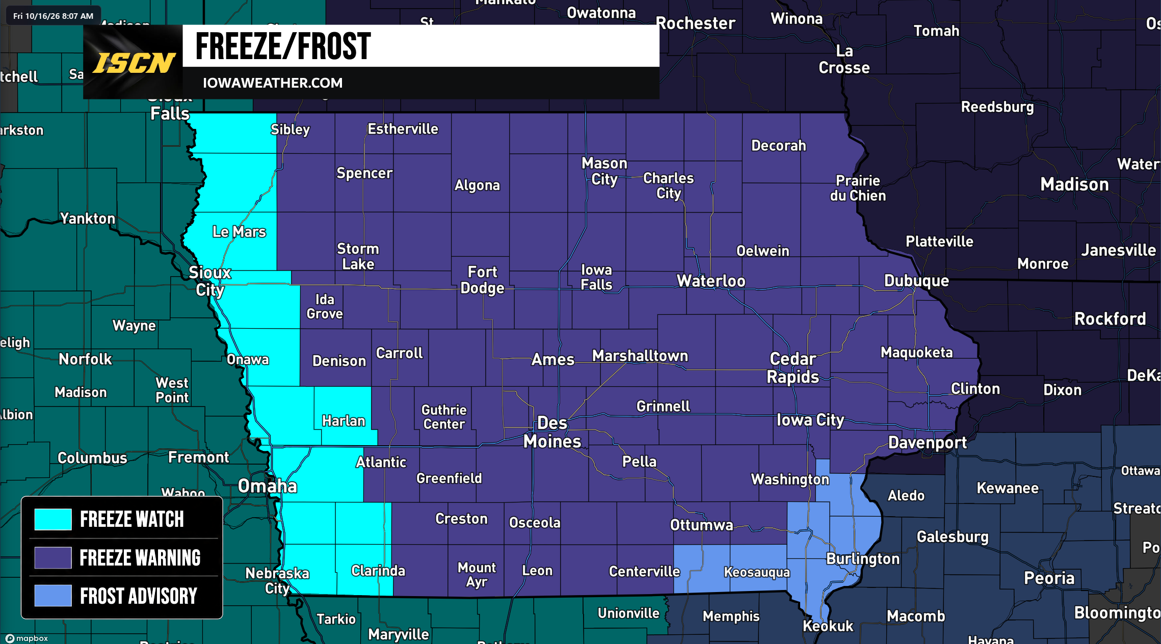 Widespread Freeze Warnings Issued Across Iowa as Temperatures Could Drop Into the 20s Saturday Morning
A widespread round of freezing temperatures is expected across Iowa early Saturday morning, prompting the National Weather Service to issue Freeze Warnings, Freeze Watches, and Frost Advisories for the entire state…
Air quality
Air quality is satisfactory, and air pollution poses little or no risk.
Forecast
- TueGood (49)
Iowa City, IA reporting area · 1 hr ago. Data from AirNow (EPA and its state, local and tribal partners); preliminary and subject to change.
Sun & moon
Nearby
- Iowa City 40 km
- Marion 5 km
- Coralville 37 km
- North Liberty 29 km
- Hiawatha 4 km
- Independence 55 km
- Anamosa 32 km
- Vinton 36 km
- Manchester 55 km
- Mount Vernon 21 km
- Monticello 46 km
- West Liberty 58 km
Forecasters' discussion
From the National Weather Service office in DVN, issued 3 hrs ago
Key Messages
- Above normal temperatures are expected to continue this week and a 55% chance of continuing through the end of October.
Short Term
Issued at 148 AM CDT Tue Oct 20 2026
A shortwave is visible in water vapor imagery just to our south, which has left a few lingering mid to high clouds over the area. However, these clouds have had little impact on radiational cooling, with much of the area already dropping into the low to mid 40s, though cooler temperatures may be possible in poor drainage areas. Despite the cool start to the day, today will be yet another day basking under the influence of high pressure. Winds will be weak but could support deep mixing, as was observed yesterday. If this happens, temperatures could be a degree or two warmer than the current forecast, which is in the low 70s.
Another shortwave will make its way along the edge of the ridge Wednesday, though any impacts will be limited once more to an increase in cloud cover due to weakening forcing and dry low levels. Otherwise, the forecast remains quite similar to today, if not a couple degrees warmer, as we continue in this pattern of pleasant fall weather.
Long Term
Issued at 148 AM CDT Tue Oct 20 2026
By Thursday, ridge amplification will be underway. The high pressure center will shift southward over the Great Lakes. As a result, highs in the mid 60s to low 70s are expected. Occasional cloud chances each day may help temper the gradual 1-2 degree increase each day. However, while above normal temperatures are expected to continue through the weekend, a warm and dry but dreary day may be in store for at least part of the weekend as warm conveyor belt processes ahead of an approaching shortwave trough may lead to increased cloud cover.
However, there is sizable uncertainty regarding whether this shortwave trough will impact the CWA and if so, when that would occur. Guidance continues to be divided on the track and timing of this trough, with the majority of models and ensembles favoring a slower track with any impacts arriving Monday or later. The exception to this is the GEFS and GFS, which favor a quicker progression with the trough reaching the forecast area by Sunday. As a result, while it appears likely that above normal temperatures will continue, there is low confidence on whether we receive measurable precipitation or continue with this stretch of dry weather.
Aviation
Issued at 619 AM CDT Tue Oct 20 2026
Brief MVFR vsbys are possible at MLI prior to 14z along the Rock river valley. Otherwise, VFR conditions will prevail through the period, with light southeast wind under 7kts.
Forecasts, observations and alerts in the United States come from the National Weather Service (NOAA); radar from NOAA's Multi-Radar Multi-Sensor system; satellite imagery from NASA's Global Imagery Browse Services (GIBS) and NOAA's GOES satellites; the map from the U.S. Geological Survey's National Map; air quality from AirNow (EPA and its partners); hurricane information from the National Hurricane Center; climate normals and records from NOAA's Regional Climate Centers (ACIS). Forecasts outside the United States and the UV index: MET Norway (CC BY 4.0); observations outside the U.S.: airport reports via NOAA's Aviation Weather Center. Place names: GeoNames (CC BY 4.0). Data are copied on a schedule and may lag the sources; for warnings that affect your safety, follow your local National Weather Service office and emergency officials. Weather news is drawn from the 4Conservative index and reflects what the press published. Terms of use.