Install
Beaver Dam, AZ Weather
Current conditions
Observed at Mesquite · 47 min ago
Forecast
10-day-
Wednesday
Isolated showers and thunderstorms before 9am, then scattered showers and thunderstorms between 9am and 2pm, then scattered showers and thunderstorms. Partly sunny. High near 83, with temperatures falling to around 79 in the afternoon. East northeast wind 7 to 24 mph, with gusts as high as 31 mph. Chance of precipitation is 50%.
-
Wednesday Night
Scattered showers and thunderstorms before 8pm, then showers and thunderstorms. Mostly cloudy, with a low around 66. East northeast wind 6 to 13 mph, with gusts as high as 20 mph. Chance of precipitation is 80%.
-
Thursday
Showers and thunderstorms. Mostly cloudy, with a high near 76. Southeast wind 7 to 15 mph. Chance of precipitation is 100%.
National Weather Service forecast updated 23 hrs ago.
Hourly
Hourly forecast- Now78°33%
- 12 PM80°39%
- 1 PM81°45%
- 2 PM81°42%
- 3 PM82°54%
- 4 PM81°48%
- 5 PM79°46%
- 6 PM77°43%
- 7 PM75°35%
- 8 PM73°32%
- 9 PM72°26%
- 10 PM71°26%
- 11 PM70°54%
- Thu12 AM69°45%
- 1 AM69°59%
- 2 AM68°75%
- 3 AM68°67%
- 4 AM67°71%
- 5 AM68°65%
- 6 AM66°65%
- 7 AM66°65%
- 8 AM68°65%
- 9 AM70°65%
- 10 AM72°65%
10-day forecast
Details- TueOct 20Isolated Showers And Thunderstorms20%66°83°
- TodayOct 21Isolated Showers And Thunderstorms then Scattered Showers And Thunderstorms75%66°83°
- ThuOct 22Showers And Thunderstorms97%57°76°
- FriOct 23Isolated Rain Showers then Mostly Sunny17%55°68°
- SatOct 24Sunny53°71°
- SunOct 25Sunny56°73°
- MonOct 26Sunny56°75°
- TueOct 27Sunny55°75°
- WedOct 28Cloudy56°75°
- ThuOct 29Cloudy57°75°
Days after the National Weather Service's seven are MET Norway's outlook, a computer model with no forecaster's review.
Radar
Full mapWeather news near Beaver Dam
More weather news-
 Sunshine brings late October warmth
Sunshine continues Saturday afternoon, with highs reaching the middle and upper 50s - A warming trend could push temperatures into the 70s by the middle of next week MADISON, Wis. (WMTV) - After Saturday got off to a…
-
 Dangerous Freeze Warnings Issued for Iowa, Wisconsin, Minnesota and Illinois as Temperatures Drop
Freeze Warnings take effect early Saturday across much of Iowa, Wisconsin, southeast and central Minnesota and northern Illinois, with lows as cold as 26 degrees expected. Seven National Weather Service offices issued…
-
 Doug Iverson's Storm Tracker Forecast | Tuesday, October 13
KPVI Finally, our first storm of the month is winding down. American Falls Police Seeking Information on Missing Person Rain Didn't Stop the Community from Coming Out for ISU Homecoming Parade The City of Idaho Falls is…
-
 KPVI Storm Tracker Alert
KPVI WIDESPREAD FREEZE is likely in the Snake River Plain late Tuesday Night into Wednesday Morning. The National Weather Service has issued a Freeze Warning from 3 to 9 a.m. on Wednesday. American Falls Police Seeking…
-
 Matt Davenport's Storm Tracker Forecast for Tuesday, October 13
KPVI One more day of rainy weather before things begin to warm up. American Falls Police Seeking Information on Missing Person Rain Didn't Stop the Community from Coming Out for ISU Homecoming Parade The City of Idaho…
-
 History shows October storms can hit Arizona hard
KOLN | Nebraska Local News, Weather, Sports | Lincoln, NE History shows October storms can hit Arizona hard Vice President J.D. Vance has not yet arrived in North Platte, but his planned visit is already filling area…
-
 MOST ACCURATE FORECAST: Flood Watches across Arizona, strong to severe storms possible
PHOENIX — A powerful fall storm is moving into Arizona. It already gave us a preview. A severe storm dropped large hail from Chandler to Mesa Tuesday night. Winds will pick up, temperatures will drop and strong to…
- Severe weather chances increase in Arizona, with hail, tornado risks
Forecasts for the storms coming to Arizona have taken a more severe turn ahead of their arrival on Wednesday, Oct. 21. Recent updates from the Storm Prediction Center increased the threat level in the state up to an…
-
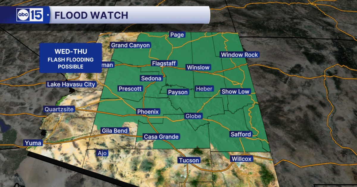 WHAT TO EXPECT: Heavy rain and flash flooding possible across Arizona midweek
Get ready for big weather changes across the state this week! A strong storm system off the California coast is pulling well-above-normal moisture into Arizona. The setup will fuel showers and thunderstorms across the…
- Flash-flood risk rises in Southern California, severe storms threaten Arizona
Satellite image of southwest U.S. at 17:20 UTC on October 20, 2026. Credit: NOAA/GOES-19, Zoom Earth, The Watchers The WPC Excessive Rainfall Discussion issued at 15:33 UTC on October 20 places portions of Southern…
Air quality
Air quality is satisfactory, and air pollution poses little or no risk.
Forecast
- WedGood
- ThuGood
- FriGood
Hurricane, UT reporting area · 1 hr ago. Data from AirNow (EPA and its state, local and tribal partners); preliminary and subject to change.
Sun & moon
Almanac
MonthlyBunkerville, records since 1979. Normals 1991–2020. Data from NOAA's Regional Climate Centers (ACIS).
Nearby
- Saint George 38 km
- Washington 46 km
- Mesquite 16 km
- Ivins 37 km
- Moapa Valley 60 km
- Santa Clara 36 km
Forecasters' discussion
From the National Weather Service office in VEF, issued 1 hr ago
Key Messages
* Tornado Watch and Flash Flood Watch in effect for Mohave County, AZ today. Strong to severe storms expected for NW Arizona and also the lower Great Basin in Inyo, Esmeralda, and Nye Counties. Damaging winds, large hail, isolated tornadoes, and heavy rain are all threats.
* Additional rounds of rain and storms expected across much of the region tonight and Thursday with mainly a heavy rain, flash flood, and lightning threat.
* Dry conditions and seasonable temperatures expected this weekend and early next week.
Aviation
For Harry Reid...For the 12Z Forecast Package...Light winds gradually veer to the east by mid-morning, increasing to around 8KT. By early to mid-afternoon, winds shift to the southeast, increasing to 10-15KT with gusts to around 20-25KT expected thereafter through sunset. Winds become light and somewhat variable overnight, increasing out of the southwest toward the end of the forecast period. Clouds will be SCT-BKN around 8-12kft through the forecast period, with some improvement expected this afternoon. While thunderstorm activity largely remains outside of the Las Vegas Valley, impacts to approaches can be expected due to scattered to numerous thunderstorms across the Mormon Mesa and Peach Springs Corridors this afternoon onward.
For the rest of southern Nevada, northwest Arizona and southeast California...For the 12Z Forecast Package...Winds around 5-10KT this morning will shift to the south and southeast by late morning into early afternoon and become elevated, with gusts to 20-30KT common through sunset. Isolated showers this morning will give way to more widespread shower and thunderstorm development by this afternoon, especially across the southern Great Basin, northwestern Arizona, and portions of southeastern California. Convection is largely expected to stay out of the vicinity of area terminals, with the exception of KBIH, where at least vicinity showers and thunderstorms are expected through the forecast period. The best window for thunderstorm impacts at KBIH will be between around 21/20Z-22/02Z, with erratic gusty winds, lightning strikes, and ceiling/visibility reductions due to rainfall expected. Cloud bases will generally be at or above 10kft, but will be as low as 6-8kft in the vicinity of convection.
Spotter Information Statement
Spotters are encouraged to report any significant weather or impacts according to standard operating procedures.
Forecasts, observations and alerts in the United States come from the National Weather Service (NOAA); radar from NOAA's Multi-Radar Multi-Sensor system; satellite imagery from NASA's Global Imagery Browse Services (GIBS) and NOAA's GOES satellites; the map from the U.S. Geological Survey's National Map; air quality from AirNow (EPA and its partners); hurricane information from the National Hurricane Center; climate normals and records from NOAA's Regional Climate Centers (ACIS). Forecasts outside the United States and the UV index: MET Norway (CC BY 4.0); observations outside the U.S.: airport reports via NOAA's Aviation Weather Center. Place names: GeoNames (CC BY 4.0). Data are copied on a schedule and may lag the sources; for warnings that affect your safety, follow your local National Weather Service office and emergency officials. Weather news is drawn from the 4Conservative index and reflects what the press published. Terms of use.