Install
Wetumpka, AL Weather
Current conditions
Observed at Montgomery, Dannelly Field · 59 min ago
Forecast
10-day-
Tonight
Clear, with a low around 50. Northeast wind around 5 mph.
-
Sunday
Sunny, with a high near 76. Northeast wind 5 to 10 mph.
-
Sunday Night
Clear, with a low around 52. Northeast wind around 5 mph.
National Weather Service forecast updated 10 hrs ago.
Hourly
Hourly forecast- Now52°
- 5 AM51°
- 6 AM51°
- 7 AM50°
- 8 AM52°
- 9 AM56°
- 10 AM64°
- 11 AM68°
- 12 PM70°
- 1 PM73°
- 2 PM74°
- 3 PM74°
- 4 PM75°
- 5 PM73°
- 6 PM70°
- 7 PM66°
- 8 PM59°
- 9 PM58°
- 10 PM57°
- 11 PM56°
- Mon12 AM55°
- 1 AM55°
- 2 AM54°
- 3 AM54°
10-day forecast
Details- TonightOct 24Clear50°
- TodayOct 25Sunny52°76°
- MonOct 26Sunny47°77°
- TueOct 27Sunny49°78°
- WedOct 28Mostly Sunny52°78°
- ThuOct 29Sunny54°80°
- FriOct 30Sunny57°82°
- SatOct 31Mostly Sunny83°
- SunNov 1Cloudy65°77°
- MonNov 2Cloudy66°79°
Days after the National Weather Service's seven are MET Norway's outlook, a computer model with no forecaster's review.
Radar
Full mapWeather news in Alabama
More weather news-
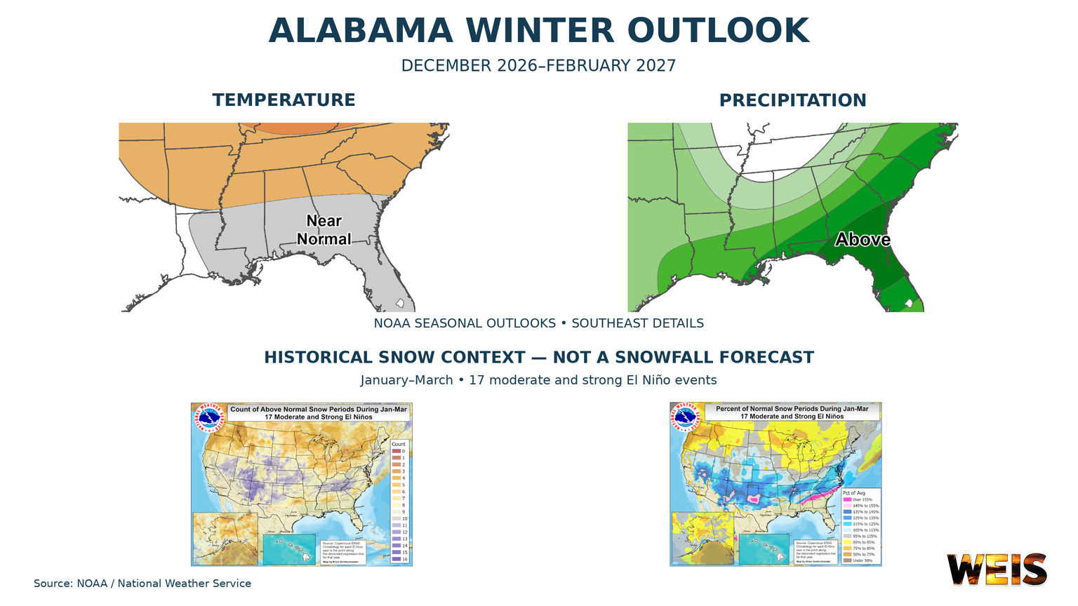 Alabama Winter Outlook Points to Wetter Conditions as El Niño Shapes the Season
CENTRE– Alabama’s winter outlook favors wetter conditions, with the strongest signal across southern Alabama and a weaker signal farther north. The outlook covers December 2026 through February 2027. NOAA released its…
- Could Alabama see perfect Thanksgiving weather? Almanac says yes
Alabama families planning to gather around the Thanksgiving table may have one less thing to worry about this year: the weather. If the Farmers' Almanac's latest forecast holds, the holiday week could bring a welcome…
-
 Alabama News Wire Forecast 10-21-2026
The Alabama News Wire
-
 First Alert Weather: Beautiful fall stretch continues: Mid-70s, sunny and dry across central Alabama
WBRC 6 News BIRMINGHAM, Ala. (WBRC) - The Next 24 Hours: We’re expecting another beautiful fall day across central Alabama, with plenty of sunshine and afternoon temperatures climbing into the mid to upper 70s. Skies…
-
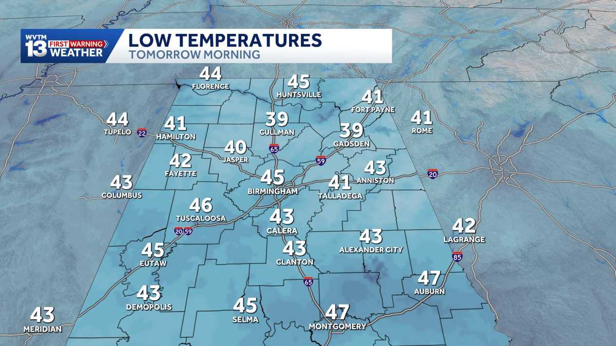 Chilly mornings and sunny, warm days in Alabama's weather forecast this week
MONDAY: Chilly morning lows down in the 40s. Warming up to the 70s with full sunshine in the afternoon. Rain chance: 0%. TUESDAY: Another chilly start in the 40s. Warming to the mid-70s in the afternoon with a light…
-
 Alabama stays rain-free all week as fall warmth builds with low humidity and clear skies
ALABAMA 7 DAY FORECAST Another pleasant fall day is on tap in Alabama as cool and dry conditions persist for another day. An upper-level ridge to our west and a building upper-level trough to our east will keep up in…
-
 Heavy rain possible for parts of Alabama this weekend; here’s where
The National Weather Service is forecasting up to 10 inches of rain for areas near Alabama's Gulf Coast over the weekend. That raises the risk for flash flooding, and a flood watch will be in effect for Mobile and…
Air quality
Acceptable. Unusually sensitive people should consider limiting prolonged outdoor exertion.
Montgomery, AL reporting area · 1 hr ago. Data from AirNow (EPA and its state, local and tribal partners); preliminary and subject to change.
Sun & moon
Almanac
MonthlyMontgomery Area, records since 1872. Normals 1991–2020. Data from NOAA's Regional Climate Centers (ACIS).
Nearby
- Montgomery 21 km
- Prattville 25 km
- Millbrook 16 km
- Alexander City 51 km
- Clanton 51 km
- Tuskegee 51 km
- Pike Road 31 km
- Tallassee 30 km
- Pine Level 24 km
- Holtville 15 km
- Dadeville 53 km
- Emerald Mountain 15 km
Forecasters' discussion
From the National Weather Service office in BMX, issued 4 hrs ago
Key Messages
Issued at 1233 AM CDT SUN OCT 25 2026
- Seasonable Conditions: Fair weather expected into next weekend.
- Fire Weather: There is a medium fire weather risk over the weekend due to dry fuels, limited moisture, and slightly increased winds.
Discussion
(Sunday through next Saturday) Issued at 1136 PM CDT SAT OCT 24 2026
Upper-level ridging will continue to remain the dominant feature for much of the upcoming workweek, with afternoon high temperatures remaining steady in the 70s. Rain chances also remain limited over the next seven days, as dry air keeps permeating the air column overhead. As we begin to approach the weekend, the upper-level ridge will begin to break down, as a deep trough develops to the west. This will put the region into SW flow, allowing for our temperatures to slightly climb into the weekend, with afternoon highs climbing into the upper-70s and low- 80s.
/44/
Aviation
(06Z TAFS) Issued at 1233 AM CDT SUN OCT 25 2026
VFR conditions will continue through for the entire TAF period, under the influence of an upper-level ridge. The only exception is that MVFR VIS may occur overnight at KASN due to patchy fog. This will quickly clear after sunrise.
Note: Fall seasonal issuance of the KASN Talladega TAF began on 10/18 00Z and will continue through 10/28 18Z.
12
Fire Weather
High pressure will allow us to maintain rain-free conditions with light winds through early next week. Daytime MinRH values are forecast to be in the 25 to 35 percent range. Winds pick up slightly over the weekend, generally in the 5-8 knot range. Given MinRH values and drying fuels, fire weather concerns will remain marginal into the weekend.
Forecasts, observations and alerts in the United States come from the National Weather Service (NOAA); radar from NOAA's Multi-Radar Multi-Sensor system; satellite imagery from NASA's Global Imagery Browse Services (GIBS) and NOAA's GOES satellites; the map from the U.S. Geological Survey's National Map; air quality from AirNow (EPA and its partners); hurricane information from the National Hurricane Center; climate normals and records from NOAA's Regional Climate Centers (ACIS). Forecasts outside the United States and the UV index: MET Norway (CC BY 4.0); observations outside the U.S.: airport reports via NOAA's Aviation Weather Center. Place names: GeoNames (CC BY 4.0). Data are copied on a schedule and may lag the sources; for warnings that affect your safety, follow your local National Weather Service office and emergency officials. Weather news is drawn from the 4Conservative index and reflects what the press published. Terms of use.