Install
Tucson, AZ 85721 Weather
Current conditions
Forecast for this hour (no station report in the last two hours)
Forecast
10-day-
Today
A chance of showers and thunderstorms. Partly sunny. High near 85, with temperatures falling to around 78 in the afternoon. South southwest wind 6 to 12 mph, with gusts as high as 23 mph. Chance of precipitation is 30%.
-
Tonight
Partly cloudy, with a low around 60. West northwest wind 3 to 7 mph.
-
Friday
Sunny, with a high near 79. West northwest wind 2 to 7 mph.
National Weather Service forecast updated 8 hrs ago.
Hourly
Hourly forecast- Now83°26%
- 1 PM84°28%
- 2 PM84°29%
- 3 PM82°30%
- 4 PM80°26%
- 5 PM78°13%
- 6 PM75°
- 7 PM73°
- 8 PM71°
- 9 PM69°
- 10 PM68°
- 11 PM66°
- Fri12 AM65°
- 1 AM64°
- 2 AM63°
- 3 AM62°
- 4 AM61°
- 5 AM61°
- 6 AM60°
- 7 AM60°
- 8 AM63°
- 9 AM68°
- 10 AM71°
- 11 AM73°
Daily forecast
Details- TodayOct 22Chance Showers And Thunderstorms30%60°85°
- FriOct 23Sunny57°79°
- SatOct 24Sunny56°77°
- SunOct 25Sunny57°78°
- MonOct 26Sunny59°82°
- TueOct 27Sunny60°84°
- WedOct 28Mostly Sunny14%61°84°
- ThuOct 29Cloudy57°88°
- FriOct 30Sunny60°85°
Days after the National Weather Service's seven are MET Norway's outlook, a computer model with no forecaster's review.
Radar
Full mapWeather news near Tucson
More weather news-
 Unusually high severe weather risk continues across Arizona through Thursday
Tucson Weather: Unusually high severe weather risk continues across Arizona through Thursday KOLD Unusually high severe weather risk continues across Arizona through Thursday Severe storms and flash flooding likely…
-
 One more day of unsettled weather with another chance of rain before we settle into some fine fall weather
TUCSON, Ariz. (KGUN) — A strong low pressure system will continue to bring unsettled weather to Arizona before giving way to some fine fall weather just in time for the weekend. A Flood Watch will remain in effect…
-
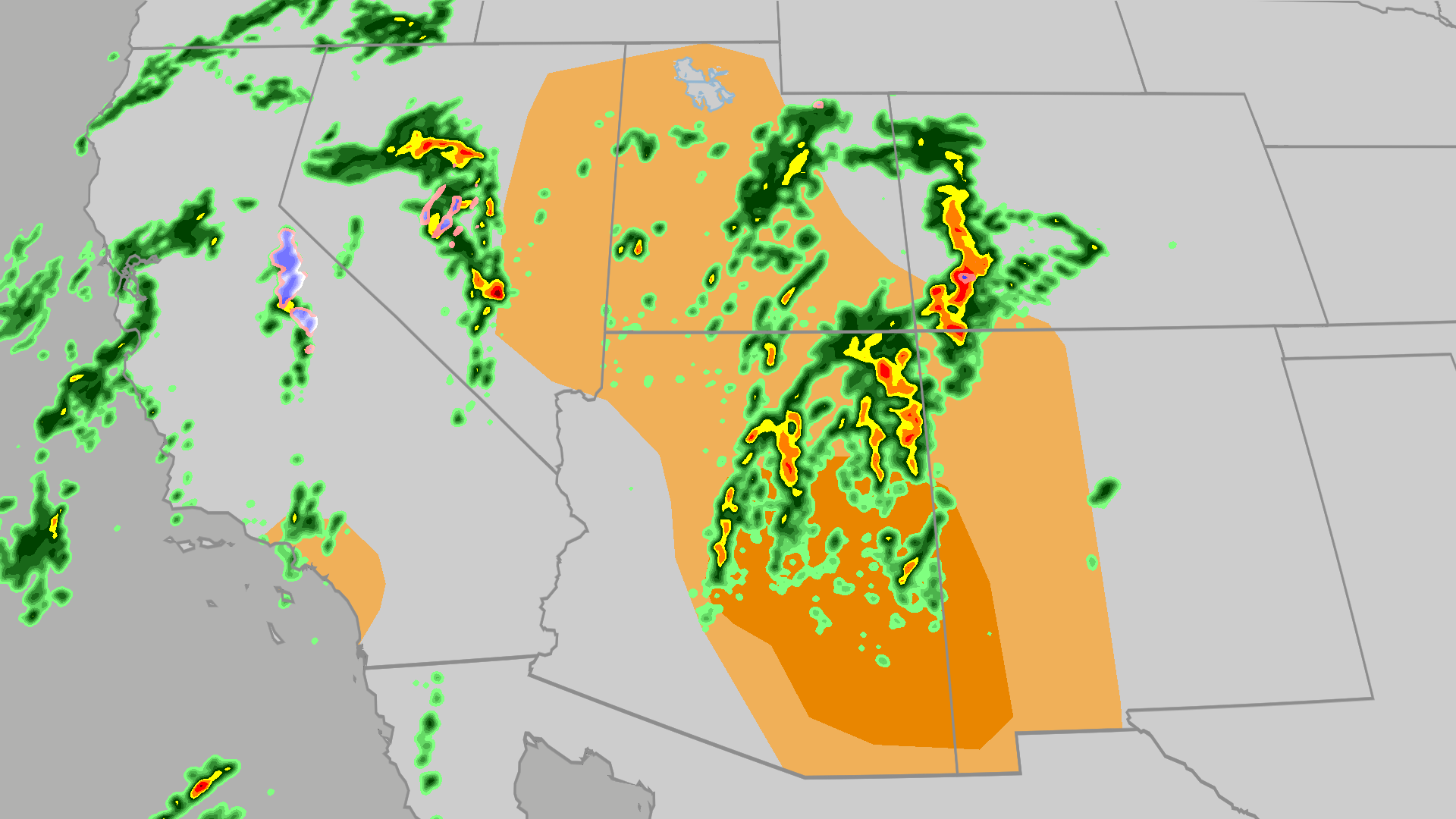 Severe weather, flood risk across Four Corners, California
The Weather Channel Tornadoes, flooding, large hail possible in Four Corners, California Parts of the Four Corners and Southern California face an elevated risk of severe weather on Thursday, which includes the…
-
 Severe Thunderstorm Warning from WED 1:09 PM MST until WED 2:00 PM MST
The National Weather Service in Tucson has issued a Severe Thunderstorm Warning for parts of southeastern Arizona. A severe thunderstorm is currently moving north at 45 mph and is expected to continue until 2 PM MST…
-
 Heavy rain and wind possible before a cooler weekend
KGUN 9 TUCSON, Ariz. (KGUN) — An unsettled weather pattern will bring another round of showers and thunderstorms to southeast Arizona today and Thursday, with some storms capable of producing heavy rain, strong winds…
-
 Severe storms and flash flooding likely across Arizona Wednesday and Thursday
Tucson Weather: Severe storms and flash flooding likely across Arizona Wednesday and Thursday KOLD Severe storms and flash flooding likely across Arizona Wednesday and Thursday Unsettled weather pattern keeps rain…
- Arizona Faces Damaging Winds, Large Hail, and an Enhanced Tornado Risk | October 21 to 22, 2026
A Stronger Severe Weather Setup Takes Shape Wednesday Impact Towards Phoenix Higher terrain east of Phoenix will become a focus for storm development Wednesday afternoon. Thunderstorms will then spread into the lower…
-
 Tropical Moisture Threatens Southwest With Flooding and Snow
SuaraGarut.ID Heavy rain fueled by tropical moisture is expected to threaten seven Southwestern states during a multiday storm system this week, increasing the risk of flash flooding, landslides and severe thunderstorms…
-
 Could a tornado hit Phoenix this week? Here’s what we’re watching.
There’s a relatively rare severe-weather risk on Wednesday in parts of Arizona and Southern California. The National Weather Service Storm Prediction Center has outlined a marginal (Level 1 out of 5) risk in an area…
-
 Foreign leaders endorse Miami Republican, sparking interference claims
There’s a relatively rare severe-weather risk on Wednesday in parts of Arizona and Southern California. The National Weather Service Storm Prediction Center has outlined a marginal (Level 1 out of 5) risk in an area…
Air quality
Air quality is satisfactory, and air pollution poses little or no risk.
Forecast
- ThuGood (39)
- FriGood (37)
- SatGood (39)
Tucson, AZ reporting area · 1 hr ago. Data from AirNow (EPA and its state, local and tribal partners); preliminary and subject to change.
Sun & moon
Almanac
MonthlyTucson Area, records since 1894. Normals 1991–2020. Data from NOAA's Regional Climate Centers (ACIS).
Nearby
- Casas Adobes 11 km
- Catalina Foothills 8 km
- Oro Valley 18 km
- Marana 34 km
- Drexel Heights 13 km
- Sahuarita 31 km
- Green Valley 42 km
- Tanque Verde 20 km
- Flowing Wells 9 km
- Saddlebrooke 34 km
- Tucson Estates 14 km
- Vail 30 km
Forecasters' discussion
From the National Weather Service office in TWC, issued 2 hrs ago
Synopsis
An unsettled weather pattern continues with strong to severe thunderstorms possible today. Main threat will be heavy rain, strong winds, hail, and potentially a tornado. This threat will be mainly contained to Graham, Greenlee, and Cochise counties, though an isolated storm can't be ruled out in Pinal, eastern Pima, or Santa Cruz county. Temperatures at or slightly above normal today and Thursday, then cooler than normal Friday into this weekend.
Update
Issued at 429 AM MST Thu Oct 22 2026. After a coordination call with SPC and PSR, a severe thunderstorm watch was issued for Pinal, Graham and Greenlee counties in our area until 11 am MST. Thunderstorms have been slowly increasing in the past hour in these counties and will continue to expand in areal coverage as the morning progresses.
Discussion
Issued at 300 AM MST Thu Oct 22 2026. Severe and flash flooding risk will be the main focus today as the strong upper level low approaching srn CA this morning moves inland and then lifts to the NE as the day progresses. PWATs remain elevated across the area, running 250-280% of normal for late October. Any thunderstorm today, especially N-NE of Tucson, will be capable of severe wind gusts of 58 mph or greater (15-18% chance), large hail of 1" or greater (15-17% chance), a tornado (5-8% chance of one occurring within 25 miles of a point), and rainfall rates of 1-2"/hr. SPC severe weather outlook has eastern Pinal/Pima, nrn Cochise, and all of Graham and Greenlee counties with Slight Risk. WPC has the area northeast of a Florence-Oracle-Willcox- San Simon line with Slight Risk of flash flooding. Current Flash flood watch remains in effect today for Pinal, Graham and Greenlee counties. CWA in a Marginal with a Slight from Tucson NE. Once again,
Drier air moves in for Friday, though some lingering showers possible near the NM border, which could linger into the weekend as well.
Temperatures near normal today, then cooler than normal Friday into this weekend. Latest NBM has a freeze potential at the highest elevations of the White Mountains Sun/Mon morning.
Aviation
Valid thru 23/12z. SCT-BKN clouds 8-12k ft AGL with SCT -SHRA/-TSRA. Any shower or storm could produce brief MVFR/IFR in addition to strong winds to 50 kts, small to marginally severe hail and brief heavy rain. SFC winds away from TS mainly less than 12 kts. Aviation discussion not updated for TAF amendments.
Forecasts, observations and alerts in the United States come from the National Weather Service (NOAA); radar from NOAA's Multi-Radar Multi-Sensor system; satellite imagery from NASA's Global Imagery Browse Services (GIBS) and NOAA's GOES satellites; the map from the U.S. Geological Survey's National Map; air quality from AirNow (EPA and its partners); hurricane information from the National Hurricane Center; climate normals and records from NOAA's Regional Climate Centers (ACIS). Forecasts outside the United States and the UV index: MET Norway (CC BY 4.0); observations outside the U.S.: airport reports via NOAA's Aviation Weather Center. Place names: GeoNames (CC BY 4.0). Data are copied on a schedule and may lag the sources; for warnings that affect your safety, follow your local National Weather Service office and emergency officials. Weather news is drawn from the 4Conservative index and reflects what the press published. Terms of use.