Install
Baton Rouge, LA 70802 Weather
Current conditions
Forecast for this hour (no station report in the last two hours)
Forecast
10-day-
Today
Sunny. High near 84, with temperatures falling to around 82 in the afternoon. Northeast wind around 5 mph.
-
Tonight
Clear. Low around 56, with temperatures rising to around 58 overnight. Northeast wind 0 to 5 mph.
-
Friday
Sunny. High near 85, with temperatures falling to around 82 in the afternoon. East wind around 5 mph.
National Weather Service forecast updated 10 hrs ago.
Hourly
Hourly forecast- Now78°
- 1 PM82°
- 2 PM83°
- 3 PM83°
- 4 PM84°
- 5 PM82°
- 6 PM80°
- 7 PM77°
- 8 PM72°
- 9 PM69°
- 10 PM67°
- 11 PM65°
- Fri12 AM63°
- 1 AM61°
- 2 AM61°
- 3 AM59°
- 4 AM58°
- 5 AM58°
- 6 AM56°
- 7 AM56°
- 8 AM58°
- 9 AM62°
- 10 AM70°
- 11 AM75°
10-day forecast
Details- TodayOct 22Sunny56°84°
- FriOct 23Sunny55°85°
- SatOct 24Sunny54°82°
- SunOct 25Sunny55°82°
- MonOct 26Mostly Sunny56°81°
- TueOct 27Mostly Sunny56°82°
- WedOct 28Sunny56°83°
- ThuOct 29Partly cloudy59°81°
- FriOct 30Cloudy62°79°
- SatOct 31Cloudy58°72°
Days after the National Weather Service's seven are MET Norway's outlook, a computer model with no forecaster's review.
Radar
Full mapWeather news near Baton Rouge
More weather news-

-
 Sunny and dry weather to continue
BATON ROUGE, La. (WAFB) - High pressure and dry weather conditions will continue through the rest of the work week with cool mornings on tap. DRY WEATHER LINGERS ON If you like the dry, nice, Chamber of Commerce…
- Dry and warming through the week, but wildfire concerns build
NEW ORLEANS (WVUE) - A quiet stretch of weather continues Tuesday afternoon, but as the week continues to get warmer and stay dry, fire concerns grow. High pressure is anchored well to our north and a ridge building…
-
 Cool mornings, warm afternoons and no rain in sight
BATON ROUGE, La. (WAFB) - Cool mornings and warm afternoons continue, with the lack of rainfall becoming an increasing concern. Another cool morning start will give way to a somewhat warmer afternoon, with highs…
-
 Dry, sunny stretch locked in across Southeast Louisiana
NEW ORLEANS (WVUE) - Dry air and sunshine are locked in for the New Orleans area this afternoon. A light breeze will keep conditions comfortable across the metro, and no rain is on the way. Highs will warm back into the…
-
 Fall temperatures fade as heat builds back
BATON ROUGE, La. (WAFB) - After a nice, cooler weekend, temperatures will gradually warm back up this week as dry weather continues. After a chilly morning start in the upper 40s, temperatures will nicely warm into the…
-

-
 Fall temperatures return with elevated fire danger
BATON ROUGE, La. (WAFB) - A strong cold front has brought cooler temperatures and elevated fire weather concerns to south Louisiana. Windy conditions will continue behind the front, but winds should begin to ease by…
-
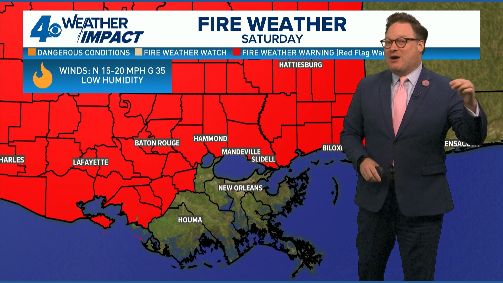 Red Flag Warning issued for parts of southeast Louisiana, southern Mississippi ahead of dry conditions
The National Weather Service has issued a Red Flag Warning for parts of southeast Louisiana and all of southern Mississippi on Friday. The warning is in effect from 9 a.m. until 8 p.m. on Saturday as forecasters say a…
-
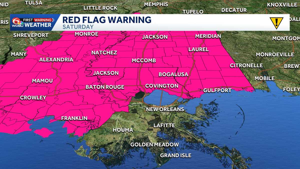 Impact Day Friday & Saturday: Red Flag Warning & Wind Advisory stretches across Southeast Louisiana
Red Flag Warning: Southeast Louisiana and Southern Mississippi Saturday The National Weather Service in New Orleans has issued a Red Flag Warning for all of southern Mississippi and parts of southeast Louisiana on…
Air quality
Acceptable. Unusually sensitive people should consider limiting prolonged outdoor exertion.
Forecast
- ThuModerate (58)
- FriModerate (64)
Baton Rouge Area, LA reporting area · 1 hr ago. Data from AirNow (EPA and its state, local and tribal partners); preliminary and subject to change.
Sun & moon
Almanac
MonthlyBaton Rouge Area, records since 1892. Normals 1991–2020. Data from NOAA's Regional Climate Centers (ACIS).
Nearby
- Central 18 km
- Prairieville 25 km
- Shenandoah 18 km
- Zachary 23 km
- Baker 16 km
- Gonzales 34 km
- Gardere 11 km
- Denham Springs 22 km
- Merrydale 9 km
- Oak Hills Place 13 km
- Donaldsonville 42 km
- Village Saint George 14 km
Forecasters' discussion
From the National Weather Service office in LIX, issued 10 hrs ago
Key Messages
Updated at 215 AM CDT Thu Oct 22 2026
- Elevated fire weather conditions will remain in place through the work week and likely increase this weekend. The rapid spread of wild fires is not substantial through Friday given the weak wind, however the current and worsening drought conditions and abundant fuels do not alleviate the fire weather concerns. Heading into the weekend winds are expected to increase the Fire Weather headlines may be needed. A Fire Danger Statement has been issued (SPSLIX) to cover this.
Short Term
(Now through Sunday) Issued at 215 AM CDT Thu Oct 22 2026
The main concern is Fire Weather and once again that is handled in the Fire Weather portion of the discussion. Outside of that it is mainly a temperature forecast which also has its impacts on the fire weather concern.
As has been discussed the last few days ridging aloft will dominate the region. The mid lvl ridge is just off to our west with the ridge axis stretching north from the TX Big Bend region through the Upper MS Valley. This ridge will slowly work east over the next few days and by the middle of the weekend the ridge may be centered directly over the Lower MS Valley. This does not bode well for any rain potential. At the sfc high pressure is also expected to remain in control and remain centered off to our NNE. By this weekend the center of the broad sfc high will drop down towards the DELMARVA region while a broad area of low pressure will develop over the Bahamas. This could become a little of a problem from a fire weather concern as it will help to tighten the pressure gradient and thus we will see winds start to pick back up, especially along the coasts and over the coastal waters but even inland where efficient mixing could allow for winds to gust to 15-20 mph and that would not be a great thing for our worsening fire weather conditions. The other issue is it could send a weak backdoor cold front into the area with LL temps dropping a touch but the bigger concern is that it would send us recycled continental dry air dropping the dewpoints even further this weekend.
NBM continues to trend a little cooler with the afternoon highs and given how bad it was earlier this week decided to continue to use a blend of the MOS values and the NBM to get a slightly better grasp on the afternoon highs. In addition used a blend of the NBM and NBM25 for dewpoints during the afternoon today and tomorrow and then with that backdoor cold front expected Saturday used straight NBM25 for dewpoints Saturday. /CAB/
Long Term
(Sunday night through Wednesday) Issued at 215 AM CDT Thu Oct 22 2026
The extended period begins with a strong upper level ridge centered over the northwestern Gulf and extending northeastward through the Great Lakes region. Meanwhile, a closed upper low over the Desert Southwest is expected to begin lifting northeastward across the Rockies Sunday night. As this system advances into the central Plains Monday, increasing southwesterly flow aloft will gradually suppress the western extent of the ridge, with the ridge substantially weakened or eroded by Tuesday. Despite this evolving upper level pattern, little change in sensible weather locally through much of the period. Surface high pressure, initially centered north of the Great Lakes, will shift southeastward toward the Carolina coast this weekend. At the same time, an approaching frontal system across the central portion of the country will contribute to a tightening pressure gradient across the northern Gulf Coast. Easterly to northeasterly winds will increase Saturday, especially across coastal areas and the tidal lakes, with the stronger gradient persisting into early next week. Not wind advisory numbers but it'll be breezy.
Temperatures will remain seasonably warm Saturday, with highs generally in the upper 70s to lower 80s. Slightly cooler conditions are anticipated Sunday as persistent easterly flow limits afternoon warming, particularly across the New Orleans metro and Mississippi Gulf Coast. Highs should generally range from the middle 70s near the coast to around 80 across the Florida Parishes and southwest Mississippi. Similar temperatures are expected Monday, with a modest warming trend possible Tuesday. Overnight lows will remain largely in the upper 40s to middle 50s inland and upper 50s to lower 60s near the coast.
Although heights aloft will gradually fall early next week, the approaching system is not currently expected to bring a meaningful increase in rain chances. Deep moisture return remains limited, and the associated surface front may struggle to advance southeastward toward the forecast area. Consequently, the prolonged dry pattern should continue through Tuesday, with any precipitation potential remaining primarily offshore. Confidence is relatively high in continued dry conditions, while uncertainty increases regarding the extent and timing of ridge breakdown and the resulting temperature response by Tuesday. Beyond that, global models suggest a dry front will be coming through in the latter half of the week. /MEFFER/
Aviation
(06Z TAFS) Issued at 215 AM CDT Thu Oct 22 2026
VFR conditions are expected to persist at all terminals through the forecast period. Ridging aloft and high pressure at the surface will continue to keep the region from seeing any significant moisture recovery and thus we will maintain mostly clear skies, with no significant ceiling or visibility restrictions anticipated. Surface winds will generally remain light. /CAB/
Forecasts, observations and alerts in the United States come from the National Weather Service (NOAA); radar from NOAA's Multi-Radar Multi-Sensor system; satellite imagery from NASA's Global Imagery Browse Services (GIBS) and NOAA's GOES satellites; the map from the U.S. Geological Survey's National Map; air quality from AirNow (EPA and its partners); hurricane information from the National Hurricane Center; climate normals and records from NOAA's Regional Climate Centers (ACIS). Forecasts outside the United States and the UV index: MET Norway (CC BY 4.0); observations outside the U.S.: airport reports via NOAA's Aviation Weather Center. Place names: GeoNames (CC BY 4.0). Data are copied on a schedule and may lag the sources; for warnings that affect your safety, follow your local National Weather Service office and emergency officials. Weather news is drawn from the 4Conservative index and reflects what the press published. Terms of use.