Install
Fargo, ND 58103 Weather
Current conditions
Observed at Fargo, Hector International Airport · 42 min ago
Forecast
10-day-
Tonight
Partly cloudy, with a low around 59. South southeast wind around 14 mph.
-
Friday
A slight chance of rain between noon and 1pm, then a chance of rain and a slight chance of thunderstorms between 1pm and 2pm, then a slight chance of thunderstorms and a slight chance of rain between 2pm and 3pm, then a chance of rain and a slight chance of thunderstorms between 3pm and 4pm. Partly sunny. High near 75, with temperatures falling to around 73 in the afternoon. South southeast wind 14 to 25 mph, with gusts as high as 40 mph. Chance of precipitation is 30%.
-
Friday Night
Mostly cloudy, with a low around 57. South southeast wind 18 to 26 mph, with gusts as high as 43 mph.
National Weather Service forecast updated 8 hrs ago.
Hourly
Hourly forecast- Now69°
- 8 PM67°
- 9 PM64°
- 10 PM63°
- 11 PM62°
- Fri12 AM62°
- 1 AM62°
- 2 AM61°
- 3 AM60°
- 4 AM59°
- 5 AM59°
- 6 AM59°
- 7 AM60°
- 8 AM60°
- 9 AM61°
- 10 AM64°
- 11 AM67°10%
- 12 PM70°15%
- 1 PM70°25%
- 2 PM72°22%
- 3 PM73°25%
- 4 PM73°14%
- 5 PM73°
- 6 PM74°
10-day forecast
Details- TodayOct 22Sunny59°75°
- FriOct 23Partly Sunny then Chance Light Rain25%57°75°
- SatOct 24Mostly Sunny34°63°
- SunOct 25Partly Sunny23%33°49°
- MonOct 26Slight Chance Light Rain21%31°47°
- TueOct 27Slight Chance Light Rain21%36°50°
- WedOct 28Slight Chance Light Rain20%36°54°
- ThuOct 29Cloudy31°40°
- FriOct 30Sunny31°51°
- SatOct 31Partly cloudy36°49°
Days after the National Weather Service's seven are MET Norway's outlook, a computer model with no forecaster's review.
Radar
Full mapWeather news near Fargo
More weather news-
 Weather Wednesday: Valley Fog
FARGO, ND — The James River Valley and the Sheyenne River Valley might not be as grandiose as the valleys in the mountains or along the Mississippi, but they do have one thing in common: valley fog. Valley fog is a type…
- Continued warmth ahead of wind/showers late week
Valley News Live Warm October temperatures and sunny skies will be the rule for much of the workweek. Our next weather maker arrives Friday, bringing wind, rain showers, and a temperature change heading into the…
-
 Warm week ahead before weekend changes start Friday
First Alert StormTeam Weather Warm October temperatures and sunny skies will be the rule for much of the workweek. Our next weather maker arrives Friday, bringing wind, rain showers, and a temperature change heading…
- Sunshine and mild temps to start the week
First Alert StormTeam Weather Cool air is settling into the region Monday morning with low temperatures dropping into the 20s and low 30s. Skies are clear and wind is light. Sunny and mild Monday - By Monday afternoon…
- A cold A.M. & a mild, sunny P.M. to start the week
recurring recording of Valley News Live at 10:00PM Sunday KX4 - VOD After a beautiful Sunday afternoon, temperatures will dive back into the 30s overnight. By Monday afternoon, we’re back in the 60s. Thereafter, the…
- Seasonable warmth & sunshine stick around Sunday into next week
recurring recording of Valley News Live at 10:00PM Saturday KVLY - VOD Sunday will end the weekend on a warm, quiet note, as afternoon highs will reach the 60s, with sunny skies. Overnight, temperatures will dip to…
- A sunny, seasonably warm pattern settles in this weekend
Valley News Live After a cold Friday night, strong southwesterly winds and sunny skies will raise Saturday’s highs into the 60s, over ten degrees warmer than average. The warmth, and sunny skies, will continue into…
- Frosty Friday night ahead of a warm, sunny weekend
Valley News Live Strong northerly winds swept through our region Thursday night heading into Friday morning. Those winds have since died down, leaving cool temperatures and sunny skies for Friday evening. Overnight into…
-
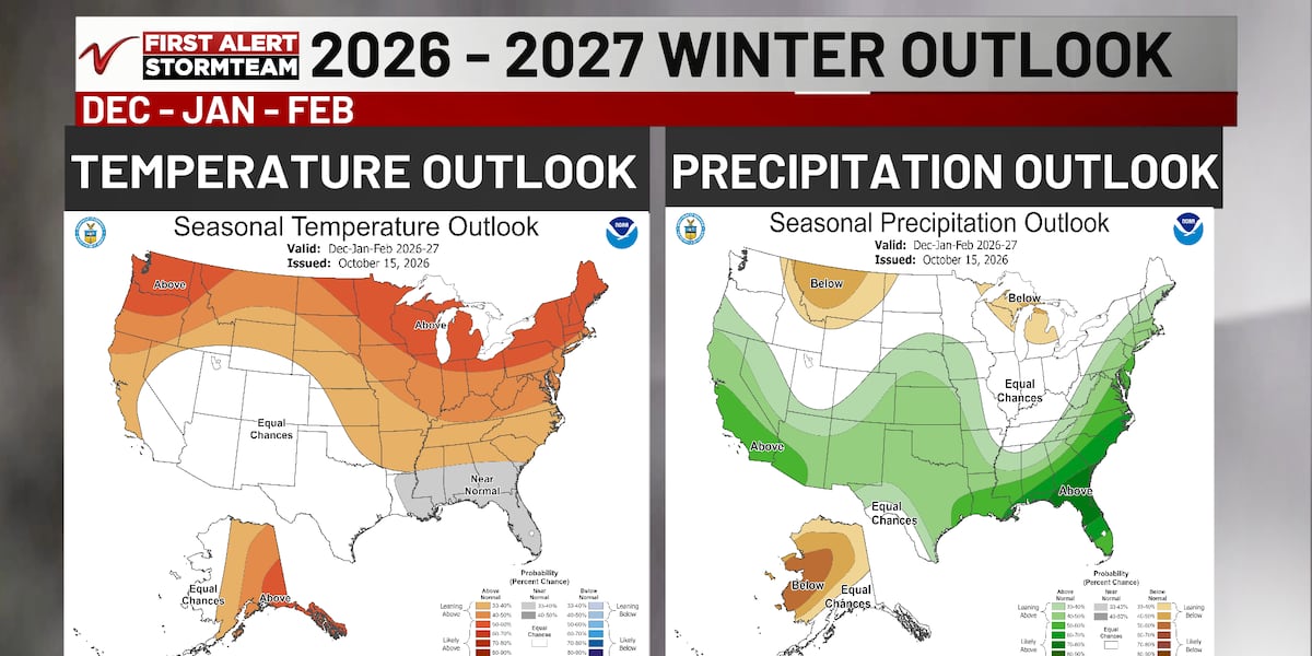 NOAA’s newest winter outlook favors mild winter for Red River Valley
FARGO, N.D. (Valley News Live) - NOAA’s newest winter outlook released Thursday tilts the Red River Valley toward warmer-than-average temperatures from December through February, fueled by a very strong El Niño. El…
- Decreasing wind on a cool Friday
Valley News Live Clearing in NE ND by Friday morning will lead to a risk of freezing temperatures in northeast ND. The wind will ease through the morning increasing that threat in those areas as well. Elsewhere, the…
Air quality
Acceptable. Unusually sensitive people should consider limiting prolonged outdoor exertion.
Fargo, ND reporting area · 1 hr ago. Data from AirNow (EPA and its state, local and tribal partners); preliminary and subject to change.
Sun & moon
Almanac
MonthlyFargo Area, records since 1881. Normals 1991–2020. Data from NOAA's Regional Climate Centers (ACIS).
Nearby
- Moorhead 4 km
- West Fargo 7 km
- Dilworth 9 km
- Barnesville 38 km
- Horace 13 km
- Casselton 31 km
- Hawley 38 km
Forecasters' discussion
From the National Weather Service office in FGF, issued 1 hr ago
Key Messages
- Well above average temperatures Thursday and Friday, followed by near average temperatures this weekend into next week.
- There is a medium chance for scattered weak thunderstorms Friday afternoon. Main hazard would be lightning.
Discussion
Issued at 342 PM CDT Thu Oct 22 2026
...Synopsis...
Blocked upper ridging remains over the central CONUS, with upper troughing over the West Coast. This upper ridging is driving well above average temperatures in the 70s currently over the region. Weak embedded impulse moving through the flow is utilizing weak instability aloft, helping spark scattered rain/virga showers in northeast ND and northwest MN this afternoon into evening. Dry air in the lower levels will prevent much of this precipitation from reaching the ground, thus added sprinkles to the forecast to account for this.
On Friday, well above average temperatures will occur once more with widespread 70s forecast during the day. While temperatures will be mild, gusty southerly winds 20-40 mph will also build starting Friday by late morning, lasting through the day.
Upper trough in the West will attempt to break eastward, although all guidance suggests this will occur in a split-flow- like regime, with the northern branch of the upper trough in northern CONUS and Canada separating from the southern branch lingering in the Southwest. As it does this, it brings sufficient moisture and lift to bring scattered showers Friday afternoon into evening. Most guidance also indicates at sufficient instability aloft to bring lightning/thunderstorms into the conversation. A lack of better instability, moisture, and wind shear spacing will mitigate how strong thunderstorms will be - likely keeping storms weak.
Strong cold front moves through Friday night into Saturday driven by the northern branch of the upper trough. This ends our well above average temperatures, with most locations seeing daily high temperatures Saturday occur just ahead of this cold front, occurring early morning Saturday.
Aviation
Issued at 628 PM CDT Thu Oct 22 2026
VFR conditions are expected to prevail through much of the TAF period at all sites. A stray shower is possible this evening, however, chances are quickly diminishing as the sun sets. Winds remain out of the southeast overnight and into Friday, with increasing cloud cover through the day on Friday. VFR ceilings are likely to continue, with a chance for showers or a stray thunderstorm during the afternoon, especially for KFAR, KBJI, and KTVF. Friday's winds remain out of the southeast, but will increase into the 15-25 knot range sustained, with gusts in the 30-35 knot range.
Fgf Watches
ND...None. MN...None.
Forecasts, observations and alerts in the United States come from the National Weather Service (NOAA); radar from NOAA's Multi-Radar Multi-Sensor system; satellite imagery from NASA's Global Imagery Browse Services (GIBS) and NOAA's GOES satellites; the map from the U.S. Geological Survey's National Map; air quality from AirNow (EPA and its partners); hurricane information from the National Hurricane Center; climate normals and records from NOAA's Regional Climate Centers (ACIS). Forecasts outside the United States and the UV index: MET Norway (CC BY 4.0); observations outside the U.S.: airport reports via NOAA's Aviation Weather Center. Place names: GeoNames (CC BY 4.0). Data are copied on a schedule and may lag the sources; for warnings that affect your safety, follow your local National Weather Service office and emergency officials. Weather news is drawn from the 4Conservative index and reflects what the press published. Terms of use.