Install
Cordova, TN 38018 Weather
Current conditions
Observed at Memphis International Airport · 17 min ago
Forecast
10-day-
This Afternoon
Sunny, with a high near 79. North northeast wind around 5 mph.
-
Tonight
Mostly clear, with a low around 49. North northeast wind 0 to 5 mph.
-
Thursday
Sunny, with a high near 79. North northeast wind 0 to 5 mph.
National Weather Service forecast updated 2 hrs ago.
Hourly
Hourly forecast- Now77°
- 6 PM73°
- 7 PM68°
- 8 PM65°
- 9 PM62°
- 10 PM60°
- 11 PM58°
- Thu12 AM57°
- 1 AM56°
- 2 AM55°
- 3 AM54°
- 4 AM51°
- 5 AM50°
- 6 AM49°
- 7 AM49°
- 8 AM50°
- 9 AM55°
- 10 AM64°
- 11 AM70°
- 12 PM73°
- 1 PM76°
- 2 PM77°
- 3 PM78°
- 4 PM79°
10-day forecast
Details- TodayOct 21Sunny49°79°
- ThuOct 22Sunny50°79°
- FriOct 23Sunny51°78°
- SatOct 24Sunny49°77°
- SunOct 25Mostly Sunny48°75°
- MonOct 26Partly Sunny49°75°
- TueOct 27Partly Sunny50°77°
- WedOct 28Sunny60°82°
- ThuOct 29Partly cloudy63°83°
- FriOct 30Partly cloudy55°72°
Days after the National Weather Service's seven are MET Norway's outlook, a computer model with no forecaster's review.
Radar
Full mapWeather news near Cordova
More weather news-
 THE BREAKDOWN: Why does tire pressure go down as the weather gets cooler?
MEMPHIS, Tenn. (WMC) - Did the tire pressure light turn on in your car this weekend? If so, you’re probably wondering how the first snap of cooler weather always seems to result in needing to fill up your car’s tires…
-
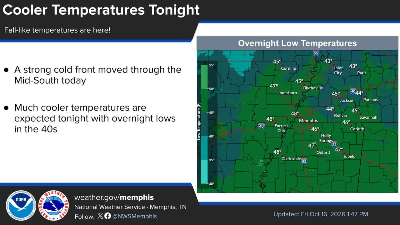 NWS Memphis says Alcorn County weekend turns colder, with frost risk Sunday morning
Alcorn County and Corinth, MS News The National Weather Service in Memphis said overnight low temperatures would fall into the 40s across much of the Mid-South after Friday's cold front. The post said Saturday would…
-
 Monday evening First Alert Forecast from Chief Meteorologist Ron Childers-October 19, 2026
Action News 5 Monday evening First Alert Forecast from Chief Meteorologist Ron Childers-October 19, 2026 THE BREAKDOWN: Why does tire pressure go down as the weather gets cooler? Residents frustrated with SpaceXAI…
-
 Chilly mornings, comfortable afternoons through the week
MEMPHIS, Tenn. - Good Monday morning! Bundle up and grab the sunglasses. It's a chilly start to the day under a mostly clear sky. Temperatures this afternoon will be slightly above average in the mid/upper 70s. Humidity…
- First Alert: Sunny skies come with a warmer afternoon Monday (10/19/2026)
Action News 5 First Alert: Sunny skies come with a warmer afternoon Monday (10/19/2026) Monday evening First Alert Forecast from Chief Meteorologist Ron Childers-October 19, 2026 THE BREAKDOWN: Why does tire pressure go…
- Sunny skies come with a warmer afternoon Monday
Action News 5 MEMPHIS, Tenn. (WMC) - Monday morning started off with chilly temperatures in the 40s around sunrise, but temperatures midday are warming through the 60s. Temperatures reach the 70s by 1pm as highs peak in…
-
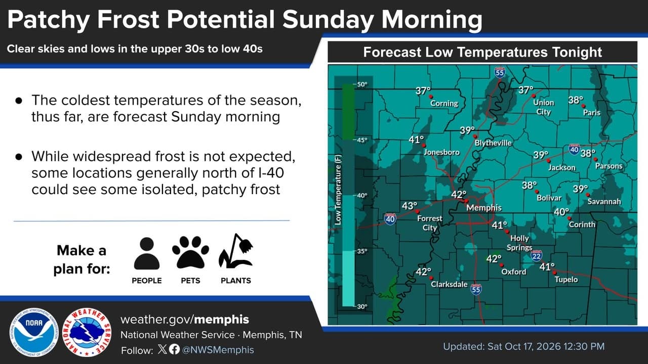 NWS Memphis forecasts cold Sunday morning and patchy frost
Alcorn County and Corinth, MS News The National Weather Service in Memphis says Sunday morning will bring the coldest temperatures of the season so far across the Mid-South. In a post shared Friday, the agency said…
- Cool Bluff City Sunday Gives Way to Sunny Warmup, Fire Danger by Midweek
The morning will feel more like late fall than mid-October, with temperatures near 42 degrees around sunrise and a chance for isolated patchy frost in colder spots north of Interstate 40. Winds should ease to around 5…
- A chilly Saturday night comes with clear skies that remain overhead Sunday
Action News 5 MEMPHIS, Tenn. (WMC) - Highs peaked in the middle 60s Saturday afternoon as a cool fall day finally made an appearance across the Mid-South with below average temperatures. Sunday sees a chilly start come…
- Sacramento Basks In One Last Sunny Weekend Before Rain Crashes Back In
Sacramento is forecast to be sunny Friday, with another 86-degree afternoon ahead. The warm spell holds through Saturday before a sharper cooldown arrives Sunday and Monday, with rain chances finally returning early…
Air quality
Acceptable. Unusually sensitive people should consider limiting prolonged outdoor exertion.
Forecast
- WedGood (50)
- ThuModerate (54)
- FriModerate (58)
Memphis, TN reporting area · 1 hr ago. Data from AirNow (EPA and its state, local and tribal partners); preliminary and subject to change.
Sun & moon
Almanac
MonthlyMemphis Area, records since 1875. Normals 1991–2020. Data from NOAA's Regional Climate Centers (ACIS).
Nearby
- Memphis 25 km
- Bartlett 10 km
- Southaven 28 km
- Collierville 16 km
- Germantown 8 km
- Olive Branch 22 km
- Horn Lake 32 km
- Ellendale 9 km
- West Memphis 37 km
- Hernando 42 km
- Lakeland 9 km
- Marion 39 km
Forecasters' discussion
From the National Weather Service office in MEG, issued 5 hrs ago
Key Messages
Issued at 1202 PM CDT Wed Oct 21 2026
- Dry weather continues, with a general warming trend back into the upper 70s to low 80s through the end of the week.
- Elevated fire danger concerns will continue each afternoon through much of this week. Obey any local burn bans and properly dispose of cigarettes and matches.
Discussion
(This evening through next Tuesday) Issued at 1202 PM CDT Wed Oct 21 2026
Dry conditions and slightly above normal temperatures continue. The 12z sounding out of LZK depicts a stout dry level between 850- 500mb. The drier air aloft will continue to mix down to the surface and lower dewpoints and relative humidity (RH) values through the afternoon. Due to the expected drop of RH values with 10 hour fuel moisture forecasts around 10%, a Fire Danger Statement is in effect from noon until 7 PM.
While we remain under surface high pressure and northwest flow aloft, expect stagnant conditions to persist for much of the forecast period. An omega blocking pattern will keep the synoptic pattern on hold through early next week. We will be monitoring the trough on the west side of the block and its evolution for next week. The LREF and its ensemble members are not too keen on impacts across the Mid-South with a gradual breakdown of the ridge and the energy heading towards the upper Midwest. Some of the longer range deterministic models are following closely behind the ensembles. In the meantime, expect dry conditions, slightly above normal temperatures, and elevated fire danger to persist.
DNM
Aviation
(18Z TAFS) Issued at 1202 PM CDT Wed Oct 21 2026
VFR and light northeast winds will continue under a persistent upper level high pressure ridge.
Fire Weather
Issued at 1202 PM CDT Wed Oct 21 2026
Elevated fire weather conditions will continue again on Thursday. Low surface moisture will lead to minimum relative humidity values dropping below 30% across the entire region. 10-hour fuels are expected to remain at or around 10 percent fuel moisture. Light 20-foot winds, likely peaking at only 10 mph throughout the afternoon, will preclude the need for Red Flag Warnings. Similar conditions will continue through the remainder of the period, likely necessitating additional Rangeland Fire Danger Statements through this week.
Forecasts, observations and alerts in the United States come from the National Weather Service (NOAA); radar from NOAA's Multi-Radar Multi-Sensor system; satellite imagery from NASA's Global Imagery Browse Services (GIBS) and NOAA's GOES satellites; the map from the U.S. Geological Survey's National Map; air quality from AirNow (EPA and its partners); hurricane information from the National Hurricane Center; climate normals and records from NOAA's Regional Climate Centers (ACIS). Forecasts outside the United States and the UV index: MET Norway (CC BY 4.0); observations outside the U.S.: airport reports via NOAA's Aviation Weather Center. Place names: GeoNames (CC BY 4.0). Data are copied on a schedule and may lag the sources; for warnings that affect your safety, follow your local National Weather Service office and emergency officials. Weather news is drawn from the 4Conservative index and reflects what the press published. Terms of use.