Install
Port Saint Lucie, FL 34986 Weather
Current conditions
Observed at Fort Pierce, St. Lucie County International Airport · 1 hr ago
Forecast
10-day-
Saturday Night
Rain showers likely. Partly cloudy, with a low around 70. Northeast wind 10 to 15 mph, with gusts as high as 30 mph. Chance of precipitation is 60%.
-
Sunday
Rain showers before 2pm, then showers and thunderstorms. Partly sunny, with a high near 83. Northeast wind 15 to 25 mph, with gusts as high as 40 mph. Chance of precipitation is 80%.
-
Sunday Night
Showers and thunderstorms. Partly cloudy, with a low around 71. Northeast wind 15 to 20 mph, with gusts as high as 35 mph. Chance of precipitation is 80%.
National Weather Service forecast updated 1 day ago.
Hourly
Hourly forecast- Now72°50%
- 1 AM72°50%
- 2 AM72°62%
- 3 AM71°62%
- 4 AM71°62%
- 5 AM70°62%
- 6 AM71°62%
- 7 AM71°62%
- 8 AM72°77%
- 9 AM75°77%
- 10 AM77°77%
- 11 AM79°77%
- 12 PM80°77%
- 1 PM81°77%
- 2 PM81°80%
- 3 PM81°80%
- 4 PM80°80%
- 5 PM78°80%
- 6 PM77°80%
- 7 PM76°80%
- 8 PM76°54%
- 9 PM75°54%
- 10 PM74°54%
- 11 PM73°54%
10-day forecast
Details- TonightOct 22Slight Chance Rain Showers15%66°
- FriOct 23Chance Rain Showers33%68°83°
- SatOct 24Chance Rain Showers62%70°83°
- TodayOct 25Rain Showers80%71°83°
- MonOct 26Chance Rain Showers53%70°83°
- TueOct 27Chance Rain Showers28%70°82°
- WedOct 28Chance Rain Showers45%69°83°
- ThuOct 29Chance Rain Showers38%84°
- FriOct 30Rain0.21 in72°80°
- SatOct 31Light showers0.06 in71°83°
Days after the National Weather Service's seven are MET Norway's outlook, a computer model with no forecaster's review.
Radar
Full mapWeather news in Florida
More weather news-
 FIRST ALERT | In for another perfect Florida Fall Day, but watch for these risks
WJHG FIRST ALERT | In for another perfect Florida Fall Day, but watch for these risks PANAMA CITY, Fla. (WJHG/WECP) - Low humidity and gusty winds still pose a fire risk continued throughout the weekend. Small Craft…
-
 Buckle Up, Southwest Florida! Windy Days Ahead Before Spotty Storms Return
Southwest Florida is heading into a windy stretch to start the week, with gusts potentially topping 35 mph Sunday and Monday. Temperatures will remain near normal, while a few showers are possible Sunday before…
-
 Talking the Tropics w/Mike: Low pressure to form east of Florida next week
104.5 WOKV The Atlantic hurricane season is June 1st through Nov. 30th. The peak of the season is September 10th. Strong wind shear has dominated much of the Atlantic Basin - especially south of about 20 degrees N. This…
-
 Low-pressure center brings strong winds and rain to central Florida
The wind today could gust to more than 30 mph across central Florida and up to 45 mph along the coast. These numbers will only increase on Sunday and Monday, when Orlando could have winds around 45 mph, and we could see…
-
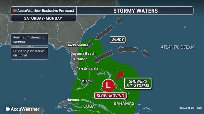 Rough Seas and Tropical Threats Loom Over Florida’s Atlantic Coast
Florida’s East Coast is already dealing with coastal flooding, gusty winds and dangerous surf, and a new area of potential tropical development could prolong or worsen those conditions early next week. Higher tides…
- Rain, strong winds and high surf ahead for Central Florida this weekend
ORLANDO, Fla. — Central Florida’s quiet weather will give way to increasing rain chances and gusty winds this weekend, with hazardous conditions developing along the coast. A trough of low pressure is expected to…
-
 Josephine, now a strong post-tropical cyclone, churns rough seas from Florida coast to Northeast
Subtropical Storm Josephine transitioned into an extratropical low Thursday afternoon, although it remained a powerful system generating dangerous swells and coastal flooding. Josephine will continue to bring high…
- A trough of low pressure will bring rain and wind to Central Florida
CENTRAL FLA. — After a quiet Friday, we are tracking Weather On the Way for the weekend. A trough of low pressure will develop over the Bahamas, increasing rain chances and wind over Central Florida. Tonight will be…
- Daily reference and potential evapotranspiration, and supporting meteorological data from weather stations, solar insolation data from the GOES satellite, and blue-sky albedo data from the MODIS satellite, Florida, 2023
Potential evapotranspiration (PET), and reference evapotranspiration (ETo) are estimated at an approximately 2-kilometer (approximately 0.019 degrees longitude and 0.018 degrees latitude) spatial grid and daily…
-
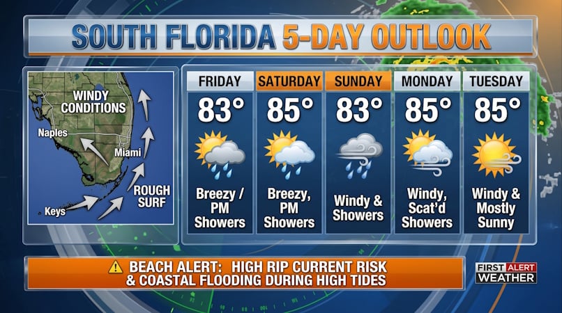 South Florida Forecast: Breezy Conditions, Persistent Beach Hazards, and Rising High Tides
Donna Thomas has studied hurricanes for two decades. She holds a PhD in history when her experience with Hurricane Andrew ultimately led her to earn a degree in broadcast meteorology from Mississippi State University…
Air quality
Air quality is satisfactory, and air pollution poses little or no risk.
Forecast
- SunModerate
- MonGood
- TueGood
Fort Pierce, FL reporting area · 1 hr ago. Data from AirNow (EPA and its state, local and tribal partners); preliminary and subject to change.
Sun & moon
Almanac
MonthlyFort Pierce Area, records since 1901. Normals 1991–2020. Data from NOAA's Regional Climate Centers (ACIS).
Nearby
- Jupiter 53 km
- Fort Pierce 16 km
- Sebastian 55 km
- Palm City 22 km
- Vero Beach South 33 km
- Florida Ridge 29 km
- Stuart 20 km
- Vero Beach 35 km
- Jensen Beach 19 km
- Hobe Sound 39 km
- Lakewood Park 25 km
- Port Salerno 28 km
Forecasters' discussion
From the National Weather Service office in MLB, issued 5 hrs ago
Key Messages
Issued at 300 PM EDT Sat Oct 24 2026
- A prolonged period of hazardous to dangerous beach and boating conditions are forecast across east central Florida through this weekend and into next week. Entering the ocean is not advised!
- Rough, dangerous surf, minor to moderate coastal flooding, moderate to major beach erosion, a high risk of rip currents, and Gale conditions are forecast this weekend and early next week.
- Increasing rain chances are forecast through the weekend. Minor flooding cannot be ruled out due to repeated rounds of showers and the potential for training bands of showers.
Discussion
Issued at 300 PM EDT Sat Oct 24 2026
Today-Tonight... High pressure holds influence over much of the eastern U.S. today. Increasing northeast winds are observed on the south side of the high pressure this afternoon with may areas of central Florida seeing peak gusts exceeding 20-25 mph so far today. A Wind Advisory is currently in effect for portions of the coast including Volusia and northern Brevard, before extending southward through the remainder of the coast this evening as wind gusts increase to 35 mph. Onshore moving showers have been ongoing through much of the morning and have shown an increase in coverage north of the Cape and the Orlando Metro early this afternoon. Rounds of scattered to numerous quick moving showers are forecast to continue through the evening and overnight, and coastal areas which see repeated rounds of heavy rainfall may become vulnerable to ponding of water or minor flooding. Despite cold temperatures aloft (500mb), poor lapse rates between the 700-500mb layer have largely limited lightning and storm potential, and lightning chances remain low through the remainder of today and into tonight. Low temperatures fall to range the upper 60s across much of east central Florida early Sunday morning while areas near the coast may hold closer to 70 degrees.
Sunday-Tuesday... A tightening pressure gradient is expected into Sunday as high pressure persists over the eastern U.S. and low pressure begins to gradually organize over the western Atlantic. Gusty northeast winds strengthen on Sunday, persisting into the workweek. A Wind Advisory continues along the coast Sunday, but most ensemble probabilities do not show enough confidence to expand inland at this time. Therefore, expect wind gusts of 30-35 mph along the coast, remaining closer to 30 mph inland on Sunday with gusty conditions persisting Monday and Tuesday. The long duration onshore wind event will continue hazardous to dangerous beach and marine conditions. A high risk of life-threatening rip currents and rough surf is expected with large breaking waves of 7-11 ft, and a High Surf Advisory continues at least through Monday. Entering the water is strongly discouraged! Long period swells exceeding 10-12 seconds combined with pounding surf will contribute to Moderate to Major beach erosion at area beaches. Wind driven coastal impacts will be further enhanced by a period of astronomical high tides. Wave runup during the morning high tide cycles will result in Minor to Moderate coastal flooding, especially Monday and Tuesday mornings, and a Coastal Flood Warning in effect Sunday and Monday will likely need to be extended into Tuesday. Heading to the beach could become hazardous, especially during times of high tide.
Passing pockets of locally higher moisture will support rounds of onshore moving showers on Sunday. Greatest rain chances are forecast in vicinity of the coastal I-95 corridor (50-80%) while scattered (20-40%) rounds of showers should still manage to push inland. Lightning chances remain low. However, showers will be capable of localized gusty winds 40-45 mph and heavy downpours. General consensus among deterministic and ensemble model suites has highlighted an area of higher QPF across portions of southeast Florida on Sunday, extending northward through portions of the Treasure Coast counties. A slight risk for excessive rainfall exists for these areas, and cannot rule out ponding water or minor flooding where multiple rounds of heavy rainfall occurs. Rounds of showers remain forecast Sunday night before a drier airmass begins to advect southward. This will reduce interior rain chances Monday and Tuesday. Scattered rain chances persist along the coast Monday, becoming limited south of the Cape by Tuesday.
High temperatures remain seasonal early next week, mostly in the low 80s. Low temperatures in the mid to upper 60s across the interior will be a few degrees warmer across the coastal counties each day.
Wednesday-Friday (previous)...Discrepancies persist in guidance relative to the strength of the pressure gradient mid to late week, primarily driven by differing placement and strength of the lingering low pressure system out in the Atlantic. These should resolve over time after the low develops. Regardless, breezy and gusty northeast winds are anticipated to persist across east central Florida, resulting in prolonged hazardous coastal and surf conditions. Additionally, this flow will support development of onshore-moving showers and isolated storms, with the highest chances focused along the coast. Lower chances across the interior, though it cannot be fully ruled out. Temperatures are forecast to remain near normal values for this time of year.
Marine
Issued at 300 AM EDT Sat Oct 24 2026
Hazardous to dangerous boating conditions are forecast across the local Atlantic waters through this weekend and into next week as a tightening pressure gradient across the local waters leads to increasing winds and seas. Northeast winds of 15 to 25 knots with gusts up to 30 knots today build to 20 to 30 knots with gusts up to 35 knots from Sunday onward. Seas of 6 to 9 feet today rapidly build tonight into Sunday up to 10 to 15 feet, highest across the Gulf Stream waters. Elevated seas are anticipated to linger through the middle of next week. A Small Craft Advisory across the local waters will upgrade into Gale Warnings, starting at 8 PM tonight across the Volusia and Brevard waters and at 8 AM Sunday across the Treasure Coast waters. For now, the Gale Warning continues through Monday, though extensions in time will be likely given the prolonged period of dangerous conditions.
Moisture increases across the local Atlantic waters through this weekend, with a return of scattered to numerous onshore-moving showers anticipated. Rain chances 40-70% today increase to 60-80% tonight through Monday, with a slight decrease in rain chances from Tuesday onward. There is a low chance (20-40%) for storm development with activity.
Aviation
(00Z TAFs) Issued at 720 PM EDT Sat Oct 24 2026
N/NE winds across the interior will decrease to around 10-12 knots, with gusts up to 18-20 knots still possible into tonight. However, along the coast it will remain breezy to windy, with wind speeds either remaining or increasing to around 15-20 knots with gusts to 25-30 knots (potentially up to 35 knots at times) as NE wind surge builds in near to after midnight. Winds areawide then increase out of the NE to 18-22 knots with gusts to 25-30 knots (up to 35 knots at times along the coast). Gusty scattered onshore moving showers are forecast through tonight and into Sunday, with a slight chance for storms as well. Have kept VCSH for much of the forecast period, with some tempo MVFR conditions at times with this activity at the coast.
Forecasts, observations and alerts in the United States come from the National Weather Service (NOAA); radar from NOAA's Multi-Radar Multi-Sensor system; satellite imagery from NASA's Global Imagery Browse Services (GIBS) and NOAA's GOES satellites; the map from the U.S. Geological Survey's National Map; air quality from AirNow (EPA and its partners); hurricane information from the National Hurricane Center; climate normals and records from NOAA's Regional Climate Centers (ACIS). Forecasts outside the United States and the UV index: MET Norway (CC BY 4.0); observations outside the U.S.: airport reports via NOAA's Aviation Weather Center. Place names: GeoNames (CC BY 4.0). Data are copied on a schedule and may lag the sources; for warnings that affect your safety, follow your local National Weather Service office and emergency officials. Weather news is drawn from the 4Conservative index and reflects what the press published. Terms of use.