Install
Sarasota, FL 34243 Weather
Current conditions
Forecast for this hour (no station report in the last two hours)
Forecast
10-day-
This Afternoon
Sunny, with a high near 81. North northeast wind around 10 mph.
-
Tonight
Clear, with a low around 62. North northeast wind around 9 mph, with gusts as high as 18 mph.
-
Friday
Sunny, with a high near 82. Northeast wind 9 to 14 mph, with gusts as high as 20 mph.
National Weather Service forecast updated 12 hrs ago.
Hourly
Hourly forecast- Now78°
- 3 PM79°
- 4 PM79°
- 5 PM79°
- 6 PM77°
- 7 PM75°
- 8 PM73°
- 9 PM71°
- 10 PM69°
- 11 PM68°
- Fri12 AM67°
- 1 AM65°
- 2 AM64°
- 3 AM63°
- 4 AM62°
- 5 AM62°
- 6 AM61°
- 7 AM60°
- 8 AM63°
- 9 AM66°
- 10 AM70°
- 11 AM74°
- 12 PM76°
- 1 PM78°
10-day forecast
Details- TodayOct 22Sunny62°81°
- FriOct 23Sunny64°82°
- SatOct 24Sunny67°83°
- SunOct 25Sunny67°84°
- MonOct 26Sunny65°83°
- TueOct 27Sunny65°83°
- WedOct 28Sunny11%65°82°
- ThuOct 29Partly cloudy69°86°
- FriOct 30Cloudy68°83°
- SatOct 31Sunny65°84°
Days after the National Weather Service's seven are MET Norway's outlook, a computer model with no forecaster's review.
Radar
Full mapWeather news near Sarasota
More weather news-
 Breezy winds, cool mornings and mild afternoons combine for lovely Suncoast weather.
SARASOTA, Fla. (WWSB) - The main weather concern, for some Suncoast residents, this week will be elevated wind speeds. This will cause Gulf waters to remain choppy for the better part of the week. It also means that…
-
 Low Humidity, High Winds, Major Sunshine
SARASOTA, Fla. (WWSB) - Saturday’s rain was mixed on the Suncoast. SRQ received a half inch (0.51) Our total for the month is 9.74”. Other areas received a quarter inch (0.22”) at Lakewood Ranch and Venice Airport…
-
 Sunday Beach and Boating Forecast
SARASOTA, Fla. (WWSB) - 🏖️ Sunday Beach Forecast - WINDY Rip Current Risk: Moderate Lightning Risk: None ⛵ Suncoast Boating Forecast A strong high pressure system is anchored over the Ohio River Valley with a remnant…
-
 Cold front brings storms, cooler air, and rough Gulf waters to the Suncoast
SARASOTA, Fla. (WWSB) - A big change in the weather is headed for Florida’s Suncoast as a cold front brings showers, thunderstorms, gusty winds and a welcome break from the heat. Today will remain warm and humid across…
-
 Trudy strengthens to a hurricane as system nears Mexico’s coast with major storm expected
ABC7 WWSB Trudy was located about 300 miles (480 kilometers) southwest of Acapulco, Mexico, with maximum sustained winds of 75 mph (120 kph), according to the U.S. National Hurricane Center in Miami. The hurricane was…
-
 Summer pattern returns through Friday
SARASOTA, Fla. (WWSB) - Big changes are headed to the Suncoast this weekend as a cold front brings cooler temperatures, gusty winds, and potentially rough boating conditions. Friday will feel more like the middle of…
-
 Rain chances climb as weekend nears
SARASOTA, Fla. (WWSB) - A stretch of sunny, warm weather continues across the Suncoast before an approaching cold front brings increasing clouds, breezy conditions and a chance of rain heading into the weekend. Today…
-
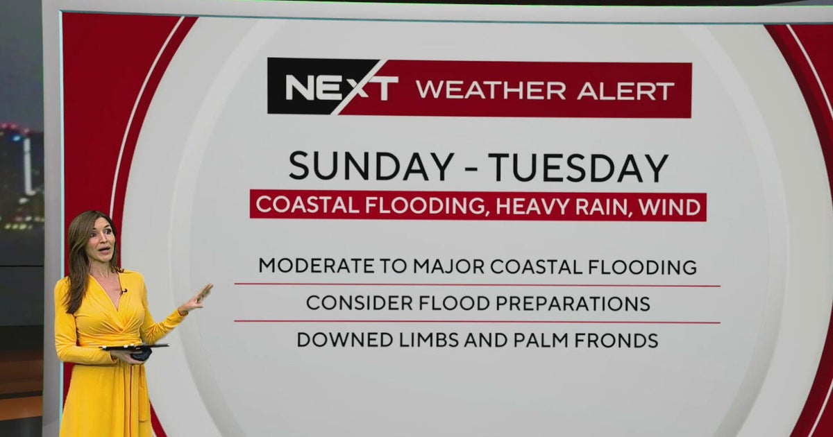 South Florida sees spotty showers ahead of weekend flooding, strong wind threats
October 22, 2026 / 7:30 AM EDT / CBS Miami South Florida will see warmer temperatures and spotty afternoon showers Thursday as the region prepares for a stretch of wet and windy weather that could bring heavy downpours…
-
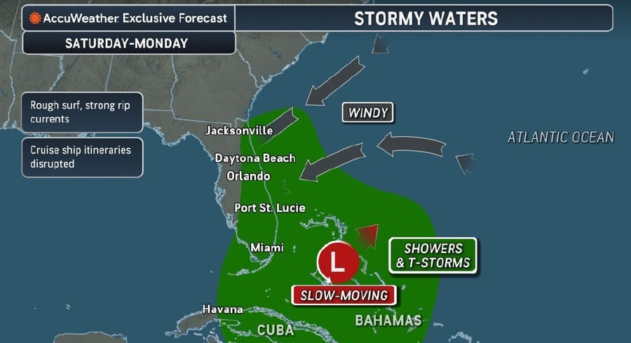 Rough Seas, Dangerous Rip Currents Threaten Florida Coast Ahead Of Possible Tropical Development
Persistent onshore winds and a slow-moving area of low pressure near the Bahamas are expected to bring hazardous surf, strong rip currents, and marine travel disruptions along Florida’s Atlantic coast starting this…
-
 Atlantic storms churn up dangerous, rough seas from Florida coast to Northeast
Subtropical Storm Josephine is expected to become a strong extratropical cyclone with hurricane-force winds as it churns in the mid-Atlantic off the U.S. East Coast, forecasters said. Josephine is bringing high winds…
Air quality
Air quality is satisfactory, and air pollution poses little or no risk.
Forecast
- ThuModerate
- FriModerate
- SatModerate
Sarasota, FL reporting area · 1 hr ago. Data from AirNow (EPA and its state, local and tribal partners); preliminary and subject to change.
Sun & moon
Almanac
MonthlySarasota-Bradenton Area, records since 1911. Normals 1991–2020. Data from NOAA's Regional Climate Centers (ACIS).
Nearby
- St. Petersburg 43 km
- Riverview 55 km
- North Port 50 km
- Bradenton 11 km
- Pinellas Park 51 km
- Venice 35 km
- South Bradenton 8 km
- West and East Lealman 48 km
- Palm River-Clair Mel 59 km
- Lealman 48 km
- Sun City Center 39 km
- Seminole 55 km
Forecasters' discussion
From the National Weather Service office in TBW, issued 7 hrs ago
Key Messages
- Hazardous marine conditions will develop across the coastal waters over the weekend.
- Near normal temperatures and dry conditions expected the remainder of the week.
Aviation
(12Z TAFS) Issued at 732 AM EDT Thu Oct 22 2026 VFR conditions are expected through the forecast period.
Discussion
Issued at 1205 AM EDT Thu Oct 22 2026 High amplitude U/L pattern will persist for the next several days with a strong U/L trough over the western U.S., strong ridging through the central U.S., and and a relatively deep trough along the eastern seaboard. An U/L disturbance will ride over the ridge Thursday night and Friday and down the backside of the trough over the eastern U.S., inducing a cut-off low over the southeast Gulf/Florida Straits area over the weekend. The system will gradually weaken and lift northeast early next week east of Florida as an U/L ridge briefly builds back over the Florida peninsula in its wake.
At the surface, strong high pressure will build over the northeast U.S. which will extend down over the southeast U.S. and Florida. A stationary frontal boundary will persist across the Florida straits. Over the weekend, the pressure gradient will tighten between the high to the north and the stationary boundary to the south as the U/L energy from the developing cut-off low overrides the frontal boundary across the Florida straits. This will create gusty northeast winds across west central and southwest Florida, with the strongest winds along the coast and over the coastal waters. A chance of showers will develop over the interior and southwest Florida due to showers advecting onshore the east central and southeastern Florida peninsula off the Atlantic in the northeast flow. Most of the activity will dissipate as it pushes inland into a drier more stable airmass over west central Florida.
Early next week, surface high pressure will remain across west central and southwest Florida with continued gusty northeast winds, however the chance of rain will diminish. The gradient will begin to relax by the middle of next week with winds subsiding.
As far as the sensible weather goes, mostly clear skies and dry conditions expected Thursday and Friday across the forecast area. Skies will become partly cloudy across most of the coastal counties with breezy conditions developing over the weekend, with the exception of southwest Florida and the interior where skies will become partly sunny with a chance of mainly afternoon showers. Early next week, skies will become partly cloudy during the day and mostly clear at night across the region. Temperature each day through the period will run near climatic normals with highs generally in the lower to mid 80s, and overnight lows in the mid to upper 50s north Thursday and Friday nights, with lower to mid 60s central and south. The entire forecast area will have lows in the 60s the remainder of the forecast period.
Marine
Issued at 1205 AM EDT Thu Oct 22 2026 Cautionary winds will occur over portions of the waters today and Friday. The gradient will tighten over the weekend with advisory level northeast winds likely across the region, and continuing into early next week. A few gusts to gale force will be possible, with the best chance over the outer waters. The offshore wind flow will also cause tides to run below astronomical levels.
Forecasts, observations and alerts in the United States come from the National Weather Service (NOAA); radar from NOAA's Multi-Radar Multi-Sensor system; satellite imagery from NASA's Global Imagery Browse Services (GIBS) and NOAA's GOES satellites; the map from the U.S. Geological Survey's National Map; air quality from AirNow (EPA and its partners); hurricane information from the National Hurricane Center; climate normals and records from NOAA's Regional Climate Centers (ACIS). Forecasts outside the United States and the UV index: MET Norway (CC BY 4.0); observations outside the U.S.: airport reports via NOAA's Aviation Weather Center. Place names: GeoNames (CC BY 4.0). Data are copied on a schedule and may lag the sources; for warnings that affect your safety, follow your local National Weather Service office and emergency officials. Weather news is drawn from the 4Conservative index and reflects what the press published. Terms of use.