Install
North Fort Myers, FL 33903 Weather
Current conditions
Observed at Fort Myers, Page Field · 45 min ago
Forecast
10-day-
Saturday Night
Mostly clear, with a low around 69. North northeast wind 10 to 14 mph, with gusts as high as 22 mph.
-
Sunday
A slight chance of rain showers after 2pm. Sunny, with a high near 84. North northeast wind 13 to 22 mph, with gusts as high as 31 mph. Chance of precipitation is 20%.
-
Sunday Night
A slight chance of rain showers before 8pm. Mostly clear, with a low around 70. North northeast wind 14 to 21 mph, with gusts as high as 31 mph. Chance of precipitation is 20%.
National Weather Service forecast updated 2 days ago.
Hourly
Hourly forecast- Now69°
- 2 AM69°
- 3 AM69°
- 4 AM69°
- 5 AM69°
- 6 AM69°
- 7 AM69°
- 8 AM70°13%
- 9 AM73°13%
- 10 AM76°13%
- 11 AM79°13%
- 12 PM81°13%
- 1 PM82°13%
- 2 PM84°20%
- 3 PM84°20%
- 4 PM82°20%
- 5 PM82°20%
- 6 PM80°20%
- 7 PM77°20%
- 8 PM76°
- 9 PM74°
- 10 PM73°
- 11 PM72°
- Mon12 AM71°
10-day forecast
Details- TonightOct 22Mostly Clear63°
- FriOct 23Sunny65°83°
- SatOct 24Sunny69°83°
- TodayOct 25Sunny then Slight Chance Rain Showers20%70°84°
- MonOct 26Sunny68°85°
- TueOct 27Sunny67°84°
- WedOct 28Sunny13%67°84°
- ThuOct 29Sunny then Slight Chance Rain Showers19%85°
- FriOct 30Rain0.07 in70°85°
- SatOct 31Light showers0.06 in69°87°
Days after the National Weather Service's seven are MET Norway's outlook, a computer model with no forecaster's review.
Radar
Full mapWeather news near North Fort Myers
More weather news-
 Southwest Florida weather forecast
WINK News Oct. 18, 2026, 6:30 p.m. Currently in Fort Myers Hour by Hour Forecast - Car crashes into Mel's Diner in Bonita Springs - Tampa Bay Rays one win from World Series after beating Cleveland 3-1 - Anthropic…
-
 FIRST ALERT | In for another perfect Florida Fall Day, but watch for these risks
WJHG FIRST ALERT | In for another perfect Florida Fall Day, but watch for these risks PANAMA CITY, Fla. (WJHG/WECP) - Low humidity and gusty winds still pose a fire risk continued throughout the weekend. Small Craft…
-
 Buckle Up, Southwest Florida! Windy Days Ahead Before Spotty Storms Return
Southwest Florida is heading into a windy stretch to start the week, with gusts potentially topping 35 mph Sunday and Monday. Temperatures will remain near normal, while a few showers are possible Sunday before…
-
 Talking the Tropics w/Mike: Low pressure to form east of Florida next week
104.5 WOKV The Atlantic hurricane season is June 1st through Nov. 30th. The peak of the season is September 10th. Strong wind shear has dominated much of the Atlantic Basin - especially south of about 20 degrees N. This…
-
 Low-pressure center brings strong winds and rain to central Florida
The wind today could gust to more than 30 mph across central Florida and up to 45 mph along the coast. These numbers will only increase on Sunday and Monday, when Orlando could have winds around 45 mph, and we could see…
-
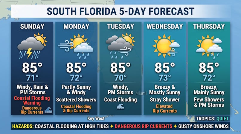 Windy Conditions, Coastal Flooding, and Passing Storms Target South Florida Through Midweek
Sunday features windy conditions with a mix of sun, clouds, morning showers, and afternoon storms in the East Coast metro area. Heavy rain is possible in spots. The Gulf Coast will be sunny and windy with the chance of…
-
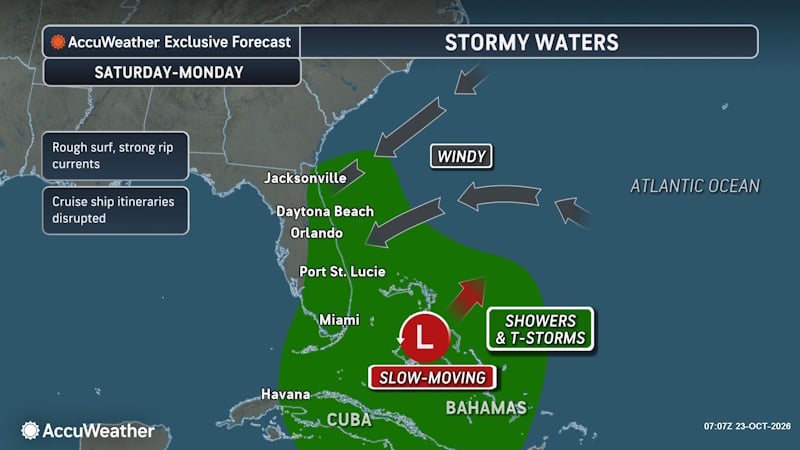 Rough Seas and Tropical Threats Loom Over Florida’s Atlantic Coast
Florida’s East Coast is already dealing with coastal flooding, gusty winds and dangerous surf, and a new area of potential tropical development could prolong or worsen those conditions early next week. Higher tides…
- Rain, strong winds and high surf ahead for Central Florida this weekend
ORLANDO, Fla. — Central Florida’s quiet weather will give way to increasing rain chances and gusty winds this weekend, with hazardous conditions developing along the coast. A trough of low pressure is expected to…
-
 Josephine, now a strong post-tropical cyclone, churns rough seas from Florida coast to Northeast
Subtropical Storm Josephine transitioned into an extratropical low Thursday afternoon, although it remained a powerful system generating dangerous swells and coastal flooding. Josephine will continue to bring high…
- A trough of low pressure will bring rain and wind to Central Florida
CENTRAL FLA. — After a quiet Friday, we are tracking Weather On the Way for the weekend. A trough of low pressure will develop over the Bahamas, increasing rain chances and wind over Central Florida. Tonight will be…
Air quality
Air quality is satisfactory, and air pollution poses little or no risk.
Forecast
- SunGood
- MonGood
- TueGood
Fort Myers, FL reporting area · 1 hr ago. Data from AirNow (EPA and its state, local and tribal partners); preliminary and subject to change.
Sun & moon
Almanac
MonthlyFort Myers Page Field Ap, records since 1892. Normals 1991–2020. Data from NOAA's Regional Climate Centers (ACIS).
Nearby
- Cape Coral 15 km
- Lehigh Acres 30 km
- Fort Myers 11 km
- North Port 51 km
- Port Charlotte 36 km
- Bonita Springs 41 km
- Estero 30 km
- Immokalee 58 km
- Punta Gorda Isles 30 km
- Punta Gorda 29 km
- San Carlos Park 27 km
- Iona 20 km
Forecasters' discussion
From the National Weather Service office in TBW, issued 5 hrs ago
Key Messages
- Hazardous marine conditions across the coastal waters will continue through the weekend and into early next week.
- Becoming breezy areawide with a slight chance of showers interior and southwest Florida over the weekend.
Update
Issued at 749 PM EDT Sat Oct 24 2026
Early evening regional METAR observations are showing the gusty north to northeast winds continuing across the area, advecting Atlantic moisture into the interior. This has led to increased cloudiness moving southwest into the forecast area, as well as some isolated light rain and sprinkles, mainly over the interior.
Mentions of sprinkles were added to the forecast for parts of the interior through the early evening. Otherwise, the forecast looks on track with breezy conditions continuing into the week.
Aviation
(00Z TAFS) Issued at 749 PM EDT Sat Oct 24 2026
Mainly VFR conditions will hold through the next 24 hours. The possible exception will be for an outside chance of MVFR or perhaps IFR ceilings overnight and into Sunday morning, but confidence is currently too low to mention in the TAFs at this time. Otherwise, breezy northeast winds will continue.
Marine
Strong winds and building large choppy seas will keep hazardous marine conditions across the coastal waters through the weekend and into early next week. The pressure gradient tightens further with wind gusts strengthening to near gale force tonight through Monday evening small craft operators should remain in port until conditions improve later next week. The offshore wind flow will also cause tides to run below astronomical levels as well.
Forecasts, observations and alerts in the United States come from the National Weather Service (NOAA); radar from NOAA's Multi-Radar Multi-Sensor system; satellite imagery from NASA's Global Imagery Browse Services (GIBS) and NOAA's GOES satellites; the map from the U.S. Geological Survey's National Map; air quality from AirNow (EPA and its partners); hurricane information from the National Hurricane Center; climate normals and records from NOAA's Regional Climate Centers (ACIS). Forecasts outside the United States and the UV index: MET Norway (CC BY 4.0); observations outside the U.S.: airport reports via NOAA's Aviation Weather Center. Place names: GeoNames (CC BY 4.0). Data are copied on a schedule and may lag the sources; for warnings that affect your safety, follow your local National Weather Service office and emergency officials. Weather news is drawn from the 4Conservative index and reflects what the press published. Terms of use.