Install
Galway, Connacht, Ireland Weather
Current conditions
Forecast for this hour (no station report in the last two hours)
Forecast
10-day-
Friday
Partly cloudy. High 11°. Precipitation 5.3 mm for the day.
-
Friday Night
Heavy rain. Low 7°. Precipitation 5.3 mm for the day.
-
Saturday
Heavy rain. High 14°. Precipitation 33.9 mm for the day.
MET Norway forecast updated 23 hrs ago.
Hourly
Hourly forecast- Now7°
- 08:007°
- 09:007°
- 10:008°
- 11:009°
- 12:0010°
- 13:0010°
- 14:0011°
- 15:0011°
- 16:0011°
- 17:0011°
- 18:009°
- 19:009°
- 20:008°
- 21:008°
- 22:009°
- 23:009°
- Sat00:0010°
- 01:0010°0.4
- 02:009°0.8
- 03:009°1.4
- 04:009°2.3
- 05:009°2.5
- 06:009°4.2
Daily forecast
DetailsRadar
Full mapWeather news near Galway
More weather news-
 Ireland weather: Exact date first named storm of season could batter country
The double storm could bring winds in excess of 80 km/h Ireland is bracing for an extended spell of wild, stormy weather, with long-range charts warning that the country could be battered by the first named storm of the…
- Forecast is for dry and bright weather this weekend
The weather in Ireland will be dry and bright this weekend but may become chilly at times, with the occasional shower. According to Met Éireann, Friday will see a mix of sunshine and showers. Rain will be most frequent…
- Status yellow rain warning issued for five counties overnight
A status yellow weather warning is in place for five counties overnight and into Thursday morning, with the possibility of localised flooding Met Éireann has said. Heavy spells of rain are expected in Donegal, Galway…
-
 Galway storm LIVE as 76km winds recorded as west under 12 hour weather warning
Heavy winds are set to hit Galway today as a Met Eireann Yellow Rain Warning is in place from 6pm. It is the second warning that Met Eireann have issued for the northwest as three counties are currently experiencing a…
-
 Status yellow rain warning issued for Leitrim
Shannonside.ie Seven counties are under weather warnings. Heavy spells of rain and strong winds are expected in parts of the west, northwest and south. Met Éireann is warning of difficult travelling conditions, wave…
-
 Heavy rain and strong winds forecast for western counties
Met Éireann has issued Status Yellow wind and rain warnings for several counties across the west and northwest today (Wednesday, October 14). A wind warning is in place for Galway, Mayo and Donegal from 6 am until 6 pm…
-
 First weather warning of the day takes effect
October 14, 2026 | 8:01 am the first of two status yellow weather warnings for counties across the west of Ireland for today has this morning come into effect. A status yellow weather warning issued by Met Éireann took…
-
 Ireland weather: Status Yellow wind and rain warnings in place for number of counties
Donegal is expected to be battered by heavy rain Status Yellow wind and rain warnings are in place for a number of counties over Wednesday and Thursday. A Status Yellow Wind warning for Donegal, Galway, and Mayo came…
- Heavy and persistent rain and possible flooding on the way as weather warnings are in place
HEAVY AND PERSISTENT rain is on the way and Met Éireann has warned of possible localised flooding as Status Yellow warnings are in place for several counties in the west. The national forecaster did not provide the…
-
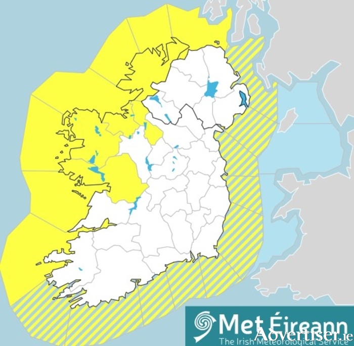 Two weather warnings in place for Galway tomorrow
by Una Sinnott Galway Advertiser, Tue, Oct 13, 2026 Two Status Yellow weather warnings have been issued for Galway tomorrow (Wednesday ), with both high winds and heavy rain forecast for the county throughout the day. A…
Sun & moon
Nearby
- Ennis 48 km
- Tuam 30 km
- Ballinasloe 56 km
- Loughrea 33 km
- Oranmore 9 km
- Athenry 21 km
- Claremorris 50 km
- Gort 28 km
- Ballinrobe 42 km
- Ballyhaunis 58 km
Forecasts, observations and alerts in the United States come from the National Weather Service (NOAA); radar from NOAA's Multi-Radar Multi-Sensor system; satellite imagery from NASA's Global Imagery Browse Services (GIBS) and NOAA's GOES satellites; the map from the U.S. Geological Survey's National Map; air quality from AirNow (EPA and its partners); hurricane information from the National Hurricane Center; climate normals and records from NOAA's Regional Climate Centers (ACIS). Forecasts outside the United States and the UV index: MET Norway (CC BY 4.0); observations outside the U.S.: airport reports via NOAA's Aviation Weather Center. Place names: GeoNames (CC BY 4.0). Data are copied on a schedule and may lag the sources; for warnings that affect your safety, follow your local National Weather Service office and emergency officials. Weather news is drawn from the 4Conservative index and reflects what the press published. Terms of use.