Install
Cruces, Cienfuegos Province, Cuba Weather
Current conditions
Forecast for this hour (no station report in the last two hours)
Forecast
10-day-
Wednesday
Heavy showers. High 29°. Precipitation 2.6 mm for the day.
-
Wednesday Night
Showers. Low 22°. Precipitation 2.6 mm for the day.
-
Thursday
Light showers. High 29°. Precipitation 0.5 mm for the day.
MET Norway forecast updated 2 hrs ago.
Hourly
Hourly forecast- Now26°
- 16:0027°
- 17:0027°0.7
- 18:0025°0.4
- 19:0024°
- 20:0023°
- 21:0023°
- 22:0023°
- 23:0022°
- Thu00:0022°
- 01:0022°
- 02:0022°
- 03:0021°
- 04:0021°
- 05:0021°
- 06:0021°
- 07:0021°
- 08:0022°
- 09:0024°
- 10:0026°
- 11:0027°0.2
- 12:0028°
- 13:0028°
- 14:0029°
10-day forecast
Details- TodayOct 21Heavy showers2.6 mm22°29°
- ThuOct 22Light showers0.5 mm21°29°
- FriOct 23Partly cloudy0.7 mm20°29°
- SatOct 24Showers2.4 mm20°26°
- SunOct 25Showers2.3 mm19°29°
- MonOct 26Heavy showers5.4 mm20°29°
- TueOct 27Partly cloudy21°29°
- WedOct 28Showers2.2 mm21°29°
- ThuOct 29Light showers0.6 mm21°30°
- FriOct 30Showers2.1 mm22°31°
Radar
Full mapWeather news near Cruces
More weather news-
 With the heat finished, Bay Area’s attention turns to rain
Only a handful of days ago, the Bay Area was enduring a last slice of heat, courtesy of the second heat wave in three weeks and one that took temperatures in downtown San Francisco into the mid-70s. Now, rain coats and…
-
 ABC-7 StormTrack Weather: Light rain chances tonight, average temps
EL PASO, Texas (KVIA) -- Monday's forecast will lean comfortable to start however rain chances will increase into midafternoon and early evening. We woke this morning to some wet roadways and chilly temps after…
- San Jose Weather Forecast 91 Degrees Friday Rain Next Week
The National Weather Service in San Francisco expects Friday's temperatures to reach their highest levels during the midafternoon, with readings around 90 degrees. Winds should stay light for much of the day before a…
- San Jose Sizzles at 91 Before Sudden Fall Flip
San Jose is starting Saturday clear and around 61 degrees, but the South Bay is headed for one more hot afternoon before fall finally takes over. Temperatures are expected to climb near 91 under sunny skies, followed by…
- Sun City Shivers Then Sizzles: El Paso Temps Rocket From 40s To 80s In Days
The National Weather Service forecast calls for east winds of 10 to 15 mph, though the breeze should ease later tonight. Saturday night will be partly cloudy with a low near 48, and no rain is expected. Sunday brings a…
-
 ABC-7 First Alert: High winds, blowing dust, cooler temps
EL PASO, Texas (KVIA) -- We remain under an ABC-7 First alert because of strong winds and cooler temps. Expect strong winds, blowing dust, and cooler temps! The National Weather Service has issued a weather alert for…
-
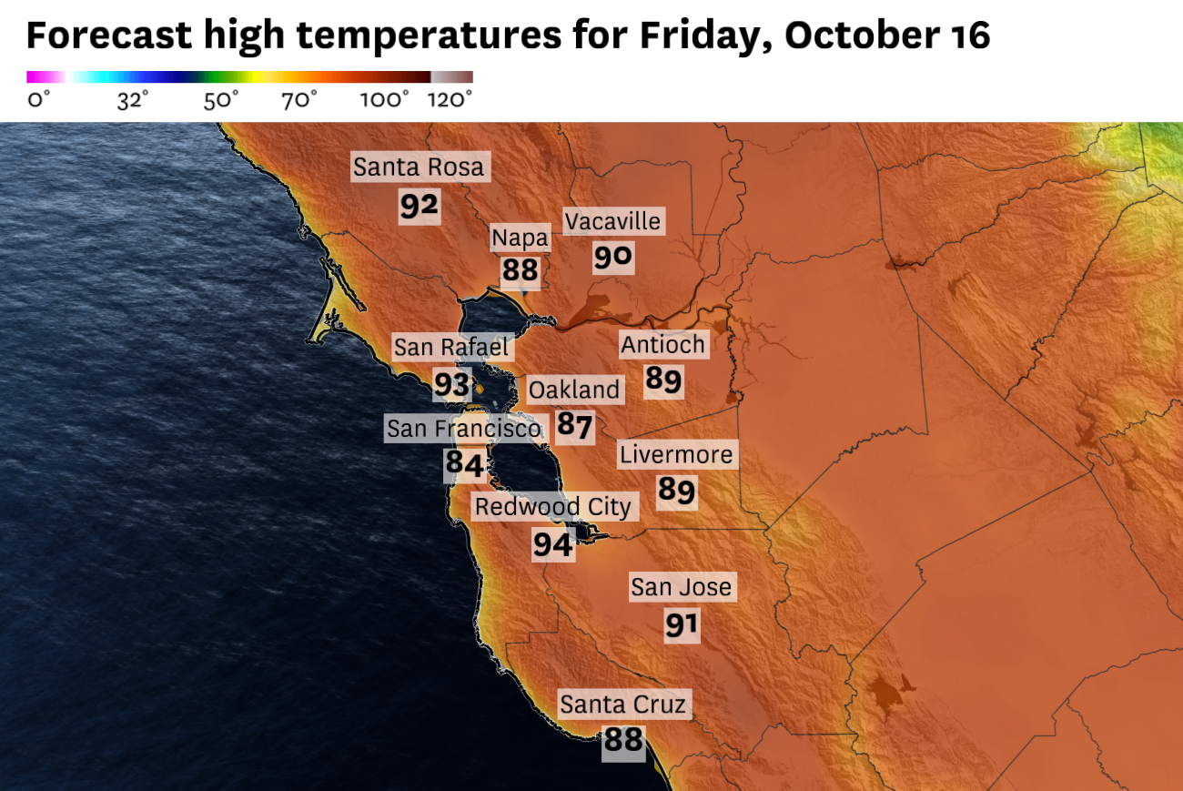 San Francisco could see its last stretch of 80-degree weather before Bay Area resets next week
Friday will be the last day of widespread hot temperatures. San Francisco could experience a final burst of 80-degree weather before a dramatic change brings much cooler temperatures to the Bay Area. The brief two day…
-
 ABC-7 First Alert Continues: Strong Backdoor Cold Front Brings Very Strong Winds, Sharp Temperature Drop to the Borderland
A powerful cold front is moving into the Borderland tonight, bringing a dramatic shift in winds, much colder temperatures and the potential for blowing dust across parts of the region. The cold front is expected to…
-
 High winds trigger NMDOT travel advisory in southern New Mexico
New Mexico transportation officials are warning drivers in southern counties about high winds, blowing dust and difficult travel conditions through October 17. New Mexico transportation agencies have issued a high wind…
-
 ABC-7 First Alert: 55 MPH gusts and 20 degree temperature drop!
EL PASO, Texas (KVIA) -- We are under an ABC-7 First Alert as a backdoor cod front is expected to arrive tonight. Temps will drop winds will pick up. The National Weather Service has issued a weather alert ahead of this…
Sun & moon
Nearby
- Santa Clara 32 km
- Cienfuegos 28 km
- Sagua la Grande 55 km
- Santo Domingo 27 km
- Ranchuelo 13 km
- Manicaragua 37 km
- Cifuentes 41 km
- Cumanayagua 22 km
- Camajuaní 56 km
- Encrucijada 52 km
- Aguada de Pasajeros 60 km
- Palmira 17 km
Forecasts, observations and alerts in the United States come from the National Weather Service (NOAA); radar from NOAA's Multi-Radar Multi-Sensor system; satellite imagery from NASA's Global Imagery Browse Services (GIBS) and NOAA's GOES satellites; the map from the U.S. Geological Survey's National Map; air quality from AirNow (EPA and its partners); hurricane information from the National Hurricane Center; climate normals and records from NOAA's Regional Climate Centers (ACIS). Forecasts outside the United States and the UV index: MET Norway (CC BY 4.0); observations outside the U.S.: airport reports via NOAA's Aviation Weather Center. Place names: GeoNames (CC BY 4.0). Data are copied on a schedule and may lag the sources; for warnings that affect your safety, follow your local National Weather Service office and emergency officials. Weather news is drawn from the 4Conservative index and reflects what the press published. Terms of use.