Install
Puerto Rico, Caquetá, Colombia Weather
Current conditions
Forecast for this hour (no station report in the last two hours)
Forecast
10-day-
Saturday
Heavy rain. High 28°. Precipitation 7.2 mm for the day.
-
Saturday Night
Rain. Low 23°. Precipitation 7.2 mm for the day.
-
Sunday
Light showers. High 32°. Precipitation 0.9 mm for the day.
MET Norway forecast updated 4 hrs ago.
Hourly
Hourly forecast- Now25°0.2
- 09:0025°0.6
- 10:0026°1.1
- 11:0026°2.2
- 12:0026°1.2
- 13:0026°
- 14:0028°
- 15:0028°
- 16:0028°
- 17:0027°
- 18:0026°0.6
- 19:0026°0.6
- 20:0026°
- 21:0025°
- 22:0025°
- 23:0025°
- Sun00:0025°
- 01:0025°
- 02:0025°
- 03:0024°
- 04:0024°
- 05:0024°
- 06:0024°
- 07:0026°
Daily forecast
DetailsRadar
Full mapWeather news near Puerto Rico
More weather news-
 When daylight saving time ends in 2026: Date clocks 'fall back' one hour
NEW YORK - As autumn settles in and the days grow shorter, an extra hour of sleep is right around the corner. Daylight saving time officially ends on Sunday, Nov. 1, 2026, at 2 a.m. local time. At that moment, clocks…
-
 Daylight Savings Time 2026: When do the clocks fall back?
The second US time change of 2026 is approaching, but millions of Americans will not need to adjust their clocks. The second time change of 2026 in the United States is approaching, as daylight saving time will soon…
-
 Slow-moving system could bring days of heavy rain and flooding to the Bahamas and Florida
A slow-moving system is developing near the Southwest Atlantic, bringing days of rain to Florida. Some areas could see 3 to 5 inches. A Level 1 out of 4 flash flood risk has been issued for Friday, while a Level 2 out…
-
 Daylight Saving Time Fast Facts
(CNN) — Here’s a look at Daylight Saving Time, a system to reduce electricity usage by extending daylight hours. Sunday, March 8, 2026 – Daylight Saving Time begins at 2am. Set clocks ahead one hour. Sunday, November 1…
-
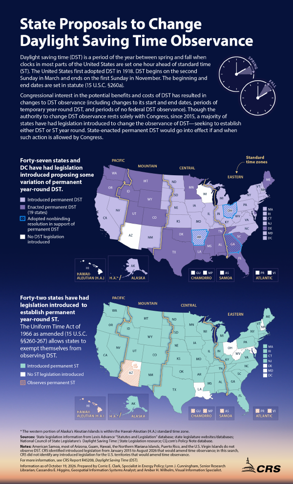 State Proposals to Change Daylight Saving Time Observance
October 19, 2026 IG10102 State Proposals to Change Daylight Saving Time Observance Daylight saving time (DST) is a period of the year between spring and fall when clocks in most parts of the United States are set one…
-
 Fall Back, Daylight Saving Time Ends Sunday November 1, 2026
It’s that time of the year, and a sign that winter is just around the corner, as Daylight Saving Time ends at 2 am Sunday, November 1, 2026. According to timeanddate.com, “In the U.S., Daylight Saving Time – or “fast…
-
 Everything you need to know about the clocks changing in 2026
As we figure out how to change the time on our cars and appliances, it's only natural to question the purpose of daylight savings time - and when it might come to an end. When do the clocks change in 2026? In Ireland…
- El Nino looms large over U.S. Winter Outlook
WDRB LOUISVILLE, Ky. (WDRB+WAVE) — NOAA’s U.S. Winter Outlook, released a few days ago, shows how El Nino will likely influence the upcoming winter months (December 2026 to February 2027), with warmer-than-average…
-
 NOT Tonight! Daylight Saving Time 2026: Clocks Fall Back Nov. 1 as Congress Weighs Permanent Change
Daylight saving time 2026 officially ends Sunday, Nov. 1, when most Americans will gain an extra hour as clocks return to standard time. The annual change happens at 2 a.m., when clocks move backward to 1 a.m. That…
-
 When do clocks fall back? 2026 daylight saving time start and end
Daylight saving time will end at 2 a.m. Sunday, Nov. 1, 2026, when clocks turn back one hour. The annual “fall back” means an extra hour of sleep and a return to standard time. It also means an earlier sunset, with…
Sun & moon
Nearby
- Florencia 59 km
- El Doncello 29 km
- El Paujíl 42 km
- La Montañita 57 km
Forecasts, observations and alerts in the United States come from the National Weather Service (NOAA); radar from NOAA's Multi-Radar Multi-Sensor system; satellite imagery from NASA's Global Imagery Browse Services (GIBS) and NOAA's GOES satellites; the map from the U.S. Geological Survey's National Map; air quality from AirNow (EPA and its partners); hurricane information from the National Hurricane Center; climate normals and records from NOAA's Regional Climate Centers (ACIS). Forecasts outside the United States and the UV index: MET Norway (CC BY 4.0); observations outside the U.S.: airport reports via NOAA's Aviation Weather Center. Place names: GeoNames (CC BY 4.0). Data are copied on a schedule and may lag the sources; for warnings that affect your safety, follow your local National Weather Service office and emergency officials. Weather news is drawn from the 4Conservative index and reflects what the press published. Terms of use.