Install
Gulin, Sichuan, China Weather
Current conditions
Forecast for this hour (no station report in the last two hours)
Forecast
10-day-
Wednesday
Rain. High 20°. Precipitation 2.9 mm for the day.
-
Wednesday Night
Rain. Low 16°. Precipitation 2.9 mm for the day.
-
Thursday
Cloudy. High 19°. Precipitation 2.9 mm for the day.
MET Norway forecast updated 4 hrs ago.
Hourly
Hourly forecast- Now19°0.2
- 02:0019°0.2
- 03:0019°0.2
- 04:0019°0.3
- 05:0019°0.2
- 06:0019°
- 07:0019°
- 08:0019°0.2
- 09:0018°0.6
- 10:0018°0.8
- 11:0018°
- 12:0018°
- 13:0020°
- 14:0020°
- 15:0020°
- 16:0020°
- 17:0019°
- 18:0019°
- 19:0018°
- 20:0017°
- 21:0017°
- 22:0016°
- 23:0016°
- Thu00:0016°
Daily forecast
DetailsRadar
Full mapWeather news in China
More weather news- Weather Today
Dongguan, 523872, Guangdong, People's Republic of China The Weather Channel Dongguan, 523872, Guangdong, People's Republic of China
-
 Heavy rain and flash flooding possible in New Mexico, southwest Colorado this week
A strong storm system will bring widespread rain to New Mexico and southwest Colorado Wednesday through Friday. Heavy rainfall could lead to flash flooding, especially Thursday and Friday. Several inches of rain are…
-
 Heavy to very heavy rainfall forecast across Bangkok and surrounding areas from 20-25 October 2026
Human Resources Online The public has been asked to be aware of dangers such as flash floods, landslides, and mudslides, especially in hillside areas near waterways and low-lying areas. The latest advisory from the Thai…
- Thailand faces heavy rain and flood risks until October 25
The Thai Meteorological Department (TMD) issued its seventh heavy-rain warning on Tuesday (October 20, 2026), alerting parts of Thailand to heavy to very heavy downpours through October 25. The warning also forecasts…
-
 Sunny, dry fall weather sticks around as rain holds off
Our weather pattern looks pretty tranquil and pleasant for quite some time. High pressure will remain in control through the end of the week and into the weekend with plenty of sunshine, dry conditions and no major…
-
 Knoxville weather: Dry and pleasant stretch this week
Calm and seasonable weather will dominate the forecast this week Tomorrow: Just a few high clouds with near-average temperatures. High: 72°. Wednesday: Plenty of sunshine and staying calm. High: 73°. The fall weather is…
-
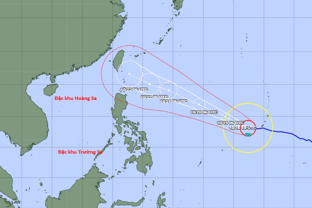 Super typhoon Champi forecast to hit Taiwan, China around October 23
The National Centre for Hydro-Meteorological Forecasting said on the afternoon of October 18 that Champi was a powerful storm over the north-western Pacific and the 30th storm to form in the region this year. Early that…
-
 Super Typhoon Champi is heading towards Taiwan (China), with a 10-20% chance of entering the South China Sea.
Super Typhoon Champi, with winds reaching level 16 and gusts exceeding level 17, is moving northwest towards Taiwan (China). Although unlikely to enter the South China Sea, the typhoon could bring winds of level 7…
- Super typhoon Champi, with gusts exceeding level 17, has a 10-20% chance of entering the South China Sea.
VTV.vn - Super typhoon Champi, with winds reaching level 16 and gusts exceeding level 17, is moving towards Taiwan (China). However, it is predicted that Champi is unlikely to enter the South China Sea. According to…
- Weather forecast for October 20th: Thunderstorms continue in Southern Vietnam, rough seas.
On October 20th, many areas in Southern Vietnam, Khanh Hoa, Dak Lak, and Lam Dong experienced thunderstorms, with some areas receiving over 50mm of rain. At sea, the weather was complex, with the risk of tornadoes…
Forecasts, observations and alerts in the United States come from the National Weather Service (NOAA); radar from NOAA's Multi-Radar Multi-Sensor system; satellite imagery from NASA's Global Imagery Browse Services (GIBS) and NOAA's GOES satellites; the map from the U.S. Geological Survey's National Map; air quality from AirNow (EPA and its partners); hurricane information from the National Hurricane Center; climate normals and records from NOAA's Regional Climate Centers (ACIS). Forecasts outside the United States and the UV index: MET Norway (CC BY 4.0); observations outside the U.S.: airport reports via NOAA's Aviation Weather Center. Place names: GeoNames (CC BY 4.0). Data are copied on a schedule and may lag the sources; for warnings that affect your safety, follow your local National Weather Service office and emergency officials. Weather news is drawn from the 4Conservative index and reflects what the press published. Terms of use.