Install
Allschwil, Basel-Landschaft, Switzerland Weather
Current conditions
Forecast for this hour (no station report in the last two hours)
Forecast
10-day-
Thursday
Cloudy. High 14°. Precipitation 0.3 mm for the day.
-
Thursday Night
Light showers. Low 6°. Precipitation 0.3 mm for the day.
-
Friday
Rain. High 15°. Precipitation 5.2 mm for the day.
MET Norway forecast updated 11 hrs ago.
Hourly
Hourly forecast- Now6°
- 07:006°
- 08:006°
- 09:007°
- 10:009°
- 11:0011°
- 12:0013°
- 13:0014°
- 14:0014°
- 15:0014°
- 16:0014°
- 17:0014°
- 18:0012°
- 19:0010°
- 20:009°
- 21:007°
- 22:006°
- 23:006°
- Fri00:005°
- 01:005°
- 02:005°
- 03:006°
- 04:007°
- 05:008°
Daily forecast
DetailsRadar
Full mapWeather news in Switzerland
More weather news-
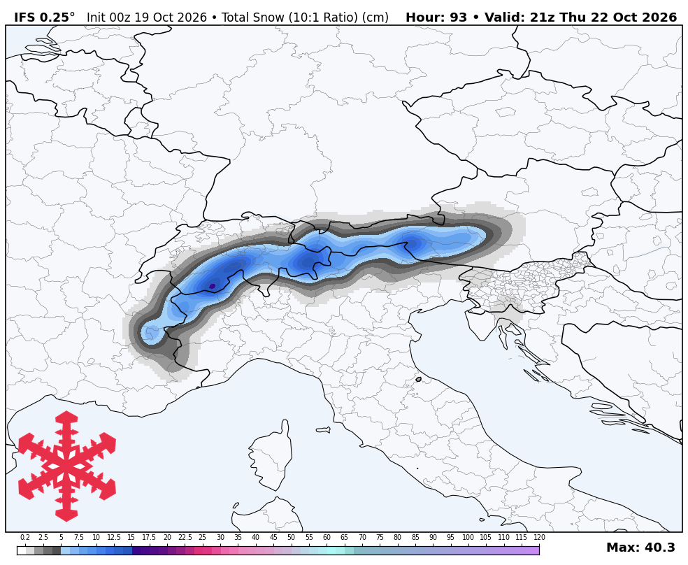
 Winter returns to Switzerland: Up to 40 centimeters of snow in the Alps, temperatures drop significantly
A cold front brings new snow to the Alps, strong winds and a significant drop in temperatures in Switzerland. A cold front is expected to sweep across Switzerland from Wednesday, bringing heavy rain, plummeting…
-
 UN: El Nino could be ‘literally off the monitoring charts’
GENEVA, Switzerland: The El Nino weather phenomenon gripping the planet could be off the charts, the United Nations warned Wednesday, saying countries should take urgent action to prepare for the worst. “The current El…
-
 SnowBrains Forecast: 20-30 cm for Cervinia as Europe Turns Colder
Steven Agar is the Chief Operating Officer of SnowBrains (est. 2013), the world's largest award-winning independent snowsports media outlet. Based in Cumbria, UK, Steven oversees editorial operations, SEO, ad revenue…
- El Nino ‘wrecking ball’ could cause record Pacific Ocean temperature rise, says UN
UN officials Celeste Saulo (left) and Tom Fletcher speaking at an El Nino press briefing on Oct 21 in Geneva, Switzerland. Published Oct 21, 2026, 11:06 PM Updated Oct 21, 2026, 11:42 PM GENEVA – The El Nino weather…
-
 Where It Gets Coldest in Northern Thailand
Home - Weather - Where It Gets Coldest in Northern Thailand The coldest conditions in Northern Thailand are usually found on high mountain peaks and exposed ridges, not in the cities below. Doi Inthanon, Doi Ang Khang…
-
 Backyard Gardener: Hard frost marks end of growing season
Hello Mid-Ohio Valley Farmers and Gardeners! Most likely we will say goodbye to the growing season this weekend in the Valley as frost is in the forecast. Any late squash, tomatoes or other vegetables need to be…
Sun & moon
Nearby
- Freiburg 55 km
- Basel 3 km
- Mulhouse 27 km
- Biel/Bienne 51 km
- Belfort 52 km
- Lörrach 12 km
- Rheinfelden 19 km
- Weil am Rhein 8 km
- Montbéliard 56 km
- Waldshut-Tiengen 52 km
- Aarau 42 km
- Saint-Louis 5 km
Forecasts, observations and alerts in the United States come from the National Weather Service (NOAA); radar from NOAA's Multi-Radar Multi-Sensor system; satellite imagery from NASA's Global Imagery Browse Services (GIBS) and NOAA's GOES satellites; the map from the U.S. Geological Survey's National Map; air quality from AirNow (EPA and its partners); hurricane information from the National Hurricane Center; climate normals and records from NOAA's Regional Climate Centers (ACIS). Forecasts outside the United States and the UV index: MET Norway (CC BY 4.0); observations outside the U.S.: airport reports via NOAA's Aviation Weather Center. Place names: GeoNames (CC BY 4.0). Data are copied on a schedule and may lag the sources; for warnings that affect your safety, follow your local National Weather Service office and emergency officials. Weather news is drawn from the 4Conservative index and reflects what the press published. Terms of use.