Install
Feira de Santana, Bahia, Brazil Weather
Current conditions
Forecast for this hour (no station report in the last two hours)
Forecast
10-day-
Sunday Night
Mostly clear. Low 26°.
-
Monday
Partly cloudy. High 39°.
-
Monday Night
Cloudy. Low 24°.
MET Norway forecast updated 27 min ago.
Hourly
Hourly forecast- Now28°
- 21:0027°
- 22:0026°
- 23:0026°
- Mon00:0025°
- 01:0025°
- 02:0024°
- 03:0024°
- 04:0024°
- 05:0024°
- 06:0025°
- 07:0027°
- 08:0029°
- 09:0032°
- 10:0034°
- 11:0036°
- 12:0037°
- 13:0038°
- 14:0039°
- 15:0039°
- 16:0035°
- 17:0033°
- 18:0031°
- 19:0030°
10-day forecast
DetailsRadar
Full mapWeather news in Brazil
More weather news-
 First Alert Weather: Local nor’easter continues with strong winds and a few showers today
Here's what the First Alert Weather Team said you can expect for the forecast: RIGHT NOW: It's a dry and warmer start to Sunday with a few showers over the Atlantic and temperatures in the mid to upper 60s. There will…
-
 Connecticut's Halloween forecast is taking shape. Here's what to expect
The National Weather Service has put out a forecast for the morning and afternoon of Halloween, with the holiday a little less than a week away. As of Sunday, the NWS shows the forecast for Oct. 31 in Connecticut as…
-
 UK clocks go back today: New time difference with Kenya and what travellers should know
Travellers between Kenya and the United Kingdom will need to adjust to a new time difference from Sunday, October 25, 2026, when the UK turns its clocks back by one hour and ends daylight saving time. The change means…
-
 Commodities Market Impact Weather
As the 2026 crop fills the hopper for DTN's View From the Cab farmers, fall operations start and plans begin to ratchet up for 2027. MINNEAPOLIS (DTN) -- Favorable harvest weather in the U.S. with a minor disruption…
-
 Vance intensifies rapidly and could become a major Category 3 hurricane off Mexico's Pacific Coast
Vance had maximum sustained winds of 110 mph (177 kph) as it churned about 385 miles (620 kilometers) south-southwest of Acapulco, according to an advisory from the Miami-based hurricane center. The storm was nearing…
-
 Preserving Native Voices-National Parks
The Batesville Daily Guard Sweetgrass grows among a variety of grasses in Bass Harbor Marsh in Acadia National Park on Mount Desert Island in Maine on Friday, July 10, 2026. There was a problem reporting this. Keep it…
- Atlantic storms churn up dangerous, rough seas from Florida coast to Northeast
Subtropical Storm Josephine is expected to become a strong extratropical cyclone with hurricane-force winds as it churns in the mid-Atlantic off the U.S. East Coast, forecasters said. Josephine is bringing high winds…
- A ‘super’ El Niño is impacting weather globally – here's how it could affect travel plans now and in the future
El Niño has officially arrived, and some forecasters are suggesting it could eventually develop into a rare “super” event capable of dramatically altering weather patterns across much of the planet, from the safari…
-
 LatAm Expat & Nomad Daily Guide for Tuesday, October 20, 2026
LatAm Expat & Nomad Daily Guide — Tuesday, October 20, 2026 As of 12:30 a.m. US Eastern Time (ET) · 1:30 a.m. Brasília, Tuesday 20 October 2026 · storm bulletin to Monday night, rates to the latest published fixing…
-
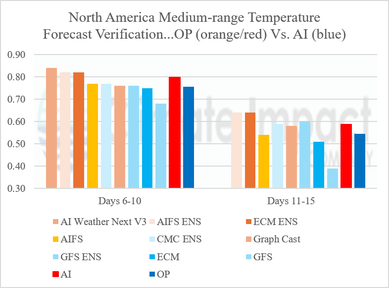 Medium-range North America Temperature Forecasts Skill Scores
Central/Northern Brazil Drought Concerns; Most Major Crop Areas Not Affected U.S. Month 1-5 Ahead Wind Forecast Climate Impact Company North America Medium Range Report Issued: Monday October 19, 2026 Highlight: Getting…
Sun & moon
Nearby
- Cruz das Almas 47 km
- Santo Amaro 42 km
- Santo Estêvão 36 km
- Maragogipe 57 km
- São Sebastião do Passé 58 km
- São Gonçalo dos Campos 19 km
- São Francisco do Conde 51 km
- Conceição do Jacuípe 22 km
- Cachoeira 37 km
- Muritiba 40 km
- Irará 32 km
- Coração de Maria 24 km
Forecasts, observations and alerts in the United States come from the National Weather Service (NOAA); radar from NOAA's Multi-Radar Multi-Sensor system; satellite imagery from NASA's Global Imagery Browse Services (GIBS) and NOAA's GOES satellites; the map from the U.S. Geological Survey's National Map; air quality from AirNow (EPA and its partners); hurricane information from the National Hurricane Center; climate normals and records from NOAA's Regional Climate Centers (ACIS). Forecasts outside the United States and the UV index: MET Norway (CC BY 4.0); observations outside the U.S.: airport reports via NOAA's Aviation Weather Center. Place names: GeoNames (CC BY 4.0). Data are copied on a schedule and may lag the sources; for warnings that affect your safety, follow your local National Weather Service office and emergency officials. Weather news is drawn from the 4Conservative index and reflects what the press published. Terms of use. How to use Weather